geo.wikisort.org - River
The Sestra (Russian: Сестра; Finnish: Rajajoki or Siestarjoki; Swedish: Systerbäck) is a river in Vsevolozhsky and Vyborgsky Districts of Leningrad Oblast and Kurortny District of Saint Petersburg, Russia. The length of the Sestra is 74 kilometres (46 mi), and the area of its basin is 399 square kilometres (154 sq mi).[1]
| Sestra Сестра Rajajoki | |
|---|---|
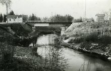
 The railway bridge over the Sestra in Beloostrov | |
| Location | |
| Country | Russia |
| Physical characteristics | |
| Mouth | |
• location | Gulf of Finland |
| Length | 74 km (46 mi)[1] |
| Basin size | 399 km2 (154 sq mi)[1] |
The Sestra flows over the Karelian Isthmus. The source of the river is in swamps west of the settlement of Vaskelovo, and the Sestra flows in the general direction south, having its mouth in the town of Sestroretsk. It used to fall into the Gulf of Finland until the early 18th century. After the construction of a dam for the needs of the munitions factory in Sestroretsk, a part of the river was turned into a reservoir called Sestroretsky Razliv (Sestroretsk Overflow), 2 metres (7 ft) deep with an area of 10.6 square kilometres (4.1 sq mi). Since then, the Sestra River has been flowing into this reservoir. The Sestroretsk Overflow is separated from the Gulf of Finland with a ridge of artificial sand dunes. Excess water is dumped into the Gulf of Finland through a canal, which is 4.8 kilometres (3.0 mi) long.
The Sestra served as a natural border between Russia and Sweden (1323–1617) and between Russia and Finland (1812–1940). It currently serves as a border between Vsevolozhsky (east, formerly Soviet Union) and Vyborgsky (west, formerly Finland) districts of Leningrad Oblast.
References
![]() Media related to Sestra River at Wikimedia Commons
Media related to Sestra River at Wikimedia Commons
- Река Сестра (Рая-Йоки) (in Russian). State Water Register of Russia. Retrieved 4 June 2013.
Rivers and canals of Saint Petersburg | ||
|---|---|---|
|  | |
На других языках
[de] Sestra (Finnischer Meerbusen)
Die Sestra (russisch Сестра, „Schwester“; finnisch Siestarjoki, „Johannisbeerefluss“ (obsolet Rajajoki, „Grenzfluss“); schwedisch Systerbäck, „Schwesterbach“) ist ein Fluss auf der Karelischen Landenge in der russischen Oblast Leningrad und dem Gebiet von Sankt Petersburg. Er hat eine Länge von 74 km und ein Einzugsgebiet von 393 km².[1]- [en] Sestra (Leningrad Oblast)
[it] Sestra (fiume)
Il Sestra in russo: Сестра ? è un fiume della Russia europea, che scorre nell'istmo di Carelia.[ru] Сестра (река, впадает в Сестрорецкий Разлив)
Сестра́ (швед. Systerbäck, фин. Rajajoki, Siestarjoki) — река на Карельском перешейке, вытекает из болот в районе посёлка Лесное и впадает в искусственное водохранилище озеро Сестрорецкий Разлив, сливаясь с Чёрной речкой. Первоначально впадала непосредственно в Финский залив в нескольких километрах к северу от Сестрорецка, в районе нынешнего устья реки Малая Сестра. Позднее русло было отведено в сторону Сестрорецка для нужд Сестрорецкого оружейного завода. Длина реки — 74 км, площадь водосборного бассейна — 399 км²[2][3]. Пойма прерывистая, ширина 10—20 м. В верховьях есть многочисленные броды, ближе к устью глубина доходит до 3 м.Другой контент может иметь иную лицензию. Перед использованием материалов сайта WikiSort.org внимательно изучите правила лицензирования конкретных элементов наполнения сайта.
WikiSort.org - проект по пересортировке и дополнению контента Википедии