geo.wikisort.org - River
The Santee River is a river in South Carolina in the United States, and is 143 miles (230 km) long. The Santee and its tributaries provide the principal drainage for the coastal areas of southeastern South Carolina and navigation for the central coastal plain of South Carolina, emptying into the Atlantic Ocean about halfway between Myrtle Beach and Charleston near the community of McClellanville. The farthest headwaters lie 440 miles (708 km) away on the Catawba River in North Carolina. Besides the Catawba, other principal rivers of the Santee watershed include the Congaree, Broad, Linville, Saluda and the Wateree. The watershed drains a large portion of the Piedmont regions of South and North Carolina. The Santee River is the second largest river on the eastern coast of the United States, second only to the Susquehanna River in drainage area and flow.[2] Much of the upper river is impounded by the expansive, horn-shaped Lake Marion reservoir, formed by the 8-mile (13 km)-long Santee Dam. The dam was built during the Great Depression of the 1930s as a Works Progress Administration (WPA) project to provide a major source of hydroelectric power for the state of South Carolina.
| Santee River | |
|---|---|
 I-95 over Lake Marion | |
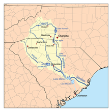 The Santee River Watershed | |
| Location | |
| Country | United States |
| States | South Carolina |
| Cities | Santee, SC, Cross, SC, Bonneau, SC, Moncks Corner, SC |
| Physical characteristics | |
| Source | Confluence of Congaree River and Wateree Rivers |
| • location | Near Fort Motte, SC |
| • coordinates | 33°44′31.78″N 80°37′02.42″W |
| • elevation | 75 ft (23 m) |
| Mouth | Atlantic Ocean |
• location | Charleston County, SC, Georgetown County, SC |
• coordinates | 33°07′48.96″N 79°15′31.73″W |
• elevation | 0 ft (0 m) |
| Length | 143 mi (230 km)}[1] |
Description
The Santee is formed in central South Carolina 25 miles (40 km) southeast of Columbia by the confluence of the Wateree and Congaree rivers. It flows southeast for 5 miles (8 km) before entering the northwest corner of Lake Marion, which stretches in a long wide arc to the southeast for approximately 30 miles (48 km) to Santee Dam. A navigable diversion canal first built in the 1970s at the southern tip of the lake connects to Lake Moultrie, a reservoir on the nearby Cooper River. The modern canal is operated by Santee Cooper as part of the larger hydroelectric project on both rivers. The dam was finished in 1941.
Downstream from the reservoir it flows east, then southeast, forming the northeast boundary of Francis Marion National Forest. Approximately 10 miles (16 km) from its mouth it bifurcates into two channels, called the North Santee and South Santee, that flow parallel and separated by approximately 2 miles (3 km), creating Cedar Island. The two channels reach the ocean at Santee Point, approximately 15 miles (24 km) south of Georgetown, and not far from the mouth of the Pee Dee River.
History

The river was named by early English settlers after the Santee tribe, which inhabited areas on the middle part of the river. The first European contact was by a Spanish party led by Lucas Vázquez de Ayllón in 1526. The Spaniards called the river the Jordan in honor of the Jordan River.
After suffering a defeat by the English and their allies during the Yamasee War in 1715–1716, the Santee were relocated. Many were shipped as slaves to the West Indies, opening up the river for British settlement as part of the Carolina Colony. Most of the Siouan peoples had migrated into the upper Midwest before European encounter.
In the late 18th century, the upper river was the site of the homestead of Francis Marion, a patriot of the American Revolutionary War. The original site of his homestead has been flooded by Lake Marion, which is named in his honor.
Construction of the 22-mile (35 km)-long Santee Canal, linking the river to the Cooper, was begun in 1793 and finished in 1800. It allowed direct water transportation between the Upcountry of central South Carolina and Charleston, at the mouth of the Cooper and the harbor. The canal operated for 50 years before being made obsolete by the introduction of railroads.
During the Great Depression, the state of South Carolina created the Santee Cooper power utility. The main source of electric power for the utility came through federal construction during the administration of President Franklin D. Roosevelt of a hydroelectric project inland from Charleston. Starting in 1939, the Santee River was dammed, forming lakes Marion and Moultrie, and diverting the river's flow into the Cooper River through a hydroelectric plant at Pinopolis. The WPA project was completed in 1941.
Though the project succeeded in providing cheap electricity to modernize rural South Carolina, unintended consequences were changes to the character of both the Cooper and Santee rivers below the project. Deprived of most its water flow, the Santee River became more saline and its ecosystem gradually changed below the dam. The Cooper River received more of the freshwater and sediment loads that used to flow into the Santee and carried them downstream. This has resulted in greatly increasing the dredging costs to keep Charleston Harbor operating as a port. In the 1980s, the Army Corps of Engineers built a "rediversion" canal to send most of the water back into the Santee, partially mitigating this problem.
Crossings
This is a partial list of crossings of the Santee River
- Lake Marion
- Railroad bridge between Lone Star and Rimini. (note: This location has been proposed by representative James Clyburn for a new automobile bridge; there is considerable controversy over the project because of its potential environmental effects.)
- Former US 15 and US 301 bridge at Santee
- Interstate 95, US 15 and US 301 bridge between Santee and North Santee
- Lower Santee
- Highway 52 bridge
- Railroad bridge near St. Stephen
- ALT US 17 bridge and adjacent railroad bridge
- US 17 bridge (S Fraser Street) over North Santee River and South Santee River
See also
- List of South Carolina rivers
- South Atlantic-Gulf Water Resource Region
References
- "The Santee River". The Sumter Item. Retrieved 14 May 2020.
- "National Water Quality Assessment Program (NAWQA): Santee River Basin Study". U. S. Geological Survey. Retrieved 29 Jan 2022.
External links
- South Carolina Dept. of Health and Environmental Control: Santee Basin
- Santee Nation History
- Santee Cooper Lake System
- Old Santee Canal Park
- Carolina Living: History of the Carolina Lakes
- Santee Canal
- U.S. Geological Survey Geographic Names Information System: Santee River
- South Atlantic Water Science Center Santee River Basin Study
| Authority control: National libraries |
|---|
На других языках
[de] Santee River
Der Santee River ist ein Fluss, der über eine Länge von 230 Kilometern im Bundesstaat South Carolina im Südosten der Vereinigten Staaten verläuft. Das Einzugsgebiet des Santee und seiner Zuflüsse ist eines der wesentlichen schiffbaren Flusssysteme der Küstenebene South Carolinas und mündet 708 Kilometer vom Ursprung seines am weitesten entfernten Quellflusses des Catawba River in North Carolina in den Atlantik. Ein großer Teil des oberen Flusslaufes wird durch den fast 13 Kilometer langen Santee-Staudamm zum hornförmigen Lake Marion Stausee aufgestaut. Der Staudamm wurde in den 1930ern als wichtige Energiequelle für den Staat zur Gewinnung von Strom durch Wasserkraft errichtet.- [en] Santee River
[es] Río Santee
El río Santee es un río de la vertiente Atlántica de los Estados Unidos que corre por la parte sureste-centro del estado de Carolina del Sur. Fluye al sudeste hasta el océano Atlántico después de un recorrido de 230 km, aunque con sus fuentes, el sistema Santee-Wateree-Catawba alcanza los 705 km de largo.[it] Santee (fiume)
Il fiume Santee è un fiume che attraversa la parte centro-meridionale dello stato della Carolina del Sud, negli Stati Uniti. Scorre in direzione nord-ovest-sud-est verso l'Oceano Atlantico dopo aver percorso 230 km, sebbene con le sue sorgenti il sistema Santee- Wateree - Catawba raggiunga i 705 km di lunghezza. Il fiume Santee è il secondo più grande della costa orientale degli Stati Uniti, dietro il fiume Susquehanna, in un'area prosciugata e fluente . [ 1 ][ru] Санти (река)
Санти (англ. Santee River) — река в штате Южная Каролина, США.Другой контент может иметь иную лицензию. Перед использованием материалов сайта WikiSort.org внимательно изучите правила лицензирования конкретных элементов наполнения сайта.
WikiSort.org - проект по пересортировке и дополнению контента Википедии