geo.wikisort.org - River
The Pee Dee River, also known as the Great Pee Dee River, is a river in the Carolinas of the United States. It originates in the Appalachian Mountains in North Carolina, where its upper course, above the mouth of the Uwharrie River, is known as the Yadkin River. The river empties into Winyah Bay, and then into the Atlantic Ocean near Georgetown.
| Pee Dee River | |
|---|---|
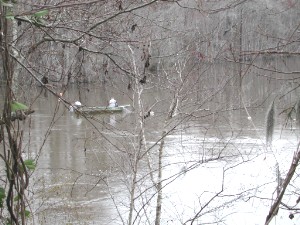 Shad fishing in February,
Pee Dee River, Yauhannah, South Carolina | |
 Pee Dee River watershed. | |
| Etymology | Pee Dee tribe |
| Location | |
| Country | United States |
| State | North Carolina, South Carolina |
| Physical characteristics | |
| Source | Confluence of Uwharrie River and Yadkin River |
| • location | North Carolina |
| • coordinates | 35°22′51″N 80°3′29″W[1] |
| • elevation | 272.3 ft (83.0 m) |
| Mouth | Winyah Bay |
• location | South Carolina |
• coordinates | 34°43′16″N 79°52′54″W[1] |
• elevation | 0 ft (0 m) |
| Length | 232 mi (373 km)[2] |
| Discharge | |
| • location | Winyah Bay |
| • average | 15000 cfs |
The river flows through the original homeland of the Pee Dee Native Americans, and is named after them. The Pee Dee are a part of the South Appalachian Mississippian Culture. They were actively built from about 1000 to 1400, leaving some centers for unknown reasons. The Pee Dee still reside in the area, with the seat of the tribal government having been located in neighboring Marlboro County since 1976.[3]
The northeastern counties of South Carolina compose the Pee Dee region of the state.
The exposed rock formations along its course are the source of a NIST reference standard.
It is an important source of electric power and public water supplies, as well as recreational use.
While the Pee Dee is free-flowing in South Carolina, upstream in North Carolina, several dams have been constructed on it. The opening and closing of these dams causes dramatic swings in the depth of the river in South Carolina. The sharing of water between the two states has sometimes been a matter of controversy, particularly during periods of drought.
Some commercial fishing is done during the winter shad run, and for shrimp in the lower reaches. The river is excellent for recreational fishing and boating.
There are numerous boat landings, yet most of the river is wild, with forests of tupelo, oak and gum along its shores. Herons and alligators can be seen along the way, and a lucky sighting of a bald eagle is possible.
The lower part of the river from Highway 378 to Winyah Bay has been designated a Scenic River.[4]
History
The first Europeans believed to have navigated part of the river was a party sent by Lucas Vázquez de Ayllón in 1521. They named it "River of St. John the Baptist."
Snow's Island is a large island at the Pee Dee and Lynches rivers junction. This was the headquarters of General Francis Marion for several months during the American Revolution. It proved a haven for him and his militia troops, as the British were unable to find the camp until it was abandoned. (It has been identified as the center of Johnsonville Impact Crater.)
The world's largest lumber company existed at the turn of the 20th century near the river's mouth at Georgetown. The virgin pine forests of the Pee Dee region were cutover, and the logs floated in rafts downriver to be sawn into lumber and exported to the northern United States and Europe.
Tributaries
Some tributaries are the Lumber, the Little Pee Dee, Lynches, Black and Waccamaw rivers.
The river was an important trade route through the Low Country from colonial times. It is navigable from the Atlantic up to the Fall Line at Cheraw.
Today the river is not extensively used for navigation.
Rice
The lower part of the river flood plain was extensively developed for rice culture in colonial time; rice was the major export of the area from the port at Georgetown. Rice culture declined with the freedom of slave labor after the Civil War and with increased overseas competition. Two hurricanes at the beginning of the 20th century destroyed much of the rice canal infrastructure and effectively ended the remnants of rice culture.
See also
- List of North Carolina rivers
- List of South Carolina rivers
- South Atlantic-Gulf Water Resource Region
- Yadkin River
- Yadkin-Pee Dee River Basin
References
- U.S. Geological Survey Geographic Names Information System: Pee Dee River
- "The National Map". U.S. Geological Survey. Retrieved Feb 14, 2011.
- "Pee Dee ~ Today 'About'". Pee Dee Indian Tribe. Retrieved 15 September 2018.
- "Designated Scenic Rivers". South Carolina Department of Natural Resources. Archived from the original on February 5, 2007.
External links
 Media related to Pee Dee River at Wikimedia Commons
Authority control | |
|---|---|
| General |
|
| Other | |
На других языках
[de] Pee Dee River
Der Pee Dee River oder auch Great Pee Dee River ist ein Fluss in den Vereinigten Staaten. Er hat seinen Ursprung in den Appalachen in North Carolina, wo sein Oberlauf oberhalb der Einmündung des Uwharrie Rivers als Yadkin River bekannt ist. Der Flusslauf ist weitgehend von Dämmen zur Flutkontrolle und zur Erzeugung von Wasserkraft begleitet. Der Name des Flusses ist von den Indianerstamm der Pee Dee abgeleitet. Stamm und Fluss gaben auch den Namen für die Pee Dee genannte Region in den nordöstlichen Countys von South Carolina.- [en] Pee Dee River
[es] Río Pee Dee
El río Pee Dee es un río de la vertiente Atlántica de los Estados Unidos que discurre por los estados de Carolina del Norte y del Sur.Другой контент может иметь иную лицензию. Перед использованием материалов сайта WikiSort.org внимательно изучите правила лицензирования конкретных элементов наполнения сайта.
WikiSort.org - проект по пересортировке и дополнению контента Википедии