geo.wikisort.org - River
The Broad River is a principal tributary of the Congaree River, about 150 miles (240 km) long,[1] in western North Carolina and northern South Carolina in the United States. Via the Congaree, it is part of the watershed of the Santee River, which flows to the Atlantic Ocean.[2]
| Broad River | |
|---|---|
 The Broad River near Blacksburg, South Carolina | |
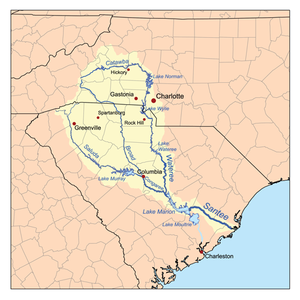 Map of the Santee River watershed showing the Broad River. | |
| Location | |
| Country | United States |
| State | North Carolina, South Carolina |
| Physical characteristics | |
| Source | |
| • location | Black Mountain, Buncombe County, North Carolina |
| • elevation | 2,890 ft (880 m) |
| Mouth | Congaree River |
• location | Columbia, Richland County, South Carolina |
• elevation | 128 ft (39 m) |
| Length | 150 mi (240 km) |
| Discharge | |
| • location | Congaree River, Columbia, South Carolina |
| Basin features | |
| Progression | Broad → Congaree → Santee → Atlantic Ocean |
| River system | Broad River |
| Tributaries | |
| • left | Little River, Green River |
| • right | Pacolet River, Enoree River |
Course
The Broad River originates in the Blue Ridge Mountains of eastern Buncombe County, North Carolina[3] and flows generally south-southeastwardly, through or along the boundaries of Rutherford, Polk and Cleveland Counties in North Carolina;[4] and Cherokee, York, Union, Chester, Fairfield, Newberry and Richland Counties in South Carolina.[2] In North Carolina, the river is dammed to form Lake Lure;[4] in South Carolina it passes through the Sumter National Forest and the communities of Cherokee Falls and Lockhart before joining the Saluda River to form the Congaree River in the city of Columbia.[2]
Principal tributaries of the Broad River include the Green, Second Broad and First Broad Rivers in North Carolina ; and the Bowens,[4] Pacolet, Sandy, Tyger, Enoree and Little Rivers in South Carolina.[2]
Dams
This is an incomplete list of dams starting at Lake Lure and moving downstream
North Carolina
- Lake Lure
- Cliffside Steam Station (Duke Energy) on the Border of Rutherford and Cleveland Counties.
South Carolina
- Gaston Shoals Dam (Gaffney)
- Cherokee Falls
- Ninety Nine Islands Dam adjacent to the abandoned Cherokee Nuclear Power Plant
- Dam and canal at Lockhart
- Neal Shoals Dam
- Parr Shoals Dam forming Parr Reservoir
- Columbia Canal and Dam in Columbia
Crossings
The Broad River is crossed several times by many highways (Note: this list at times may be incomplete)
North Carolina
- Rutherford County


 US 64 / US 74 Alt.
 NC 108 (Tryon Road)
- Grays Road
- Union Road
- US 74
- Poors Ford Road
- Big Island Road
- Jack McKinney Road
 US 221
- US 221 Alt.
- Cleveland County
 NC 150 (Gaffney Road)
South Carolina
- Gaffney/Cherokee County
 SC 18 (Shelby Highway)
 I-85
I-85 US 29 (Cherokee Avenue)
 SC 211 (Hickory Grove Road)
- Chester and Union Counties

 SC 9 / SC 49 (Pinkney Road) in Lockhart
 SC 72 / SC 215 in Carlisle
- Fairfield and Newberry Counties
 SC 34 (Newberry Road)
 SC 213 (Parr Road) in Peak
- Columbia
 I-20
I-20 US 176 (Broad River Road)
 I-126
I-126
Variant names
According to the Geographic Names Information System, the Broad River has also been known as[5]
- Eswa Huppeday
- Eswawpuddenah
- Line River
- Main Broad River
- Eswan Happedaw
It was also known in colonial times as the English Broad River to distinguish it from the French Broad River which also originates in western North Carolina, but flows northwest.
The present name is descriptive of the river's width.[6]
See also
- French Broad River
- List of North Carolina rivers
- List of South Carolina rivers
References
- Houghton Mifflin Company (1997). The Houghton Mifflin Dictionary of Geography. Boston: Houghton Mifflin Company. ISBN 0-395-86448-8
- DeLorme (1998). South Carolina Atlas & Gazetteer. Yarmouth, Maine: DeLorme. ISBN 0-89933-237-4
- Columbia Gazetteer of North America entry for Broad River Archived 2005-10-03 at the Wayback Machine
- DeLorme (2001). North Carolina Atlas & Gazetteer. Yarmouth, Maine: DeLorme. ISBN 0-89933-277-3
- U.S. Geological Survey Geographic Names Information System: Broad River
- Lake, William C. (22 June 1935). "Names of Union Streams Have Interesting History". Spartanburg Herald-Journal. pp. A1. Retrieved 22 April 2015.
| Authority control: National libraries |
|---|
На других языках
[de] Broad River (Congaree River)
Der Broad River ist einer der Quellflüsse des Congaree River. Er ist etwa 240 Kilometer lang[1] und fließt im Westen North Carolina und im Norden des Nachbarstaates South Carolina im Südosten der Vereinigten Staaten von Amerika. Durch die Einmündung in den Congaree wird der Broad River Teil des Einzugsgebietes des Santee River, der in den Atlantik fließt.[2]- [en] Broad River (Carolinas)
[es] Río Broad
El río Broad (en inglés, Broad River) es un río estadounidense que discurre por Carolina del Norte y Carolina del Sur. Nace en el suroeste de Carolina del Norte y fluye en dirección sureste hasta unirse con el río Saluda en la ciudad de Columbia (Carolina del Sur) formando en esta unión el río Congaree que posteriormente se unirá al río Wateree, formando estos dos últimos el río Santee, que desemboca en el océano Atlántico al norte de la ciudad de Charleston.[1][2]Другой контент может иметь иную лицензию. Перед использованием материалов сайта WikiSort.org внимательно изучите правила лицензирования конкретных элементов наполнения сайта.
WikiSort.org - проект по пересортировке и дополнению контента Википедии