geo.wikisort.org - River
The Rakaia River is in the Canterbury Plains in New Zealand's South Island.[1] The Rakaia River is one of the largest braided rivers in New Zealand.[2] The Rakaia River has a mean flow of 203 cubic metres per second (7,200 cu ft/s) and a mean annual seven-day low flow of 87 m3/s (3,100 cu ft/s).[3] In the 1850s, European settlers named it the Cholmondeley River, but this name lapsed into disuse.[4]
| Rakaia River | |
|---|---|
 Rakaia River mouth | |
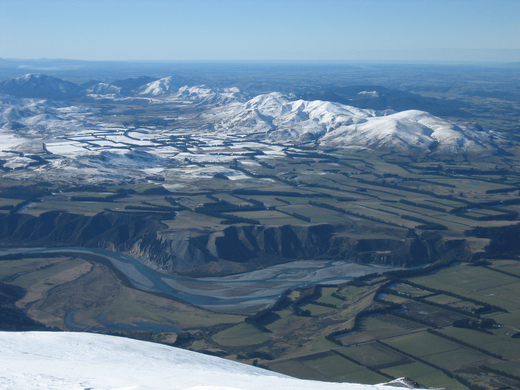
 The Rakaia River system | |
| Native name | Rakaia (Māori) |
| Physical characteristics | |
| Source | Southern Alps |
| Length | 150 kilometres (93 mi) |
| Discharge | |
| • average | 203 cubic metres per second (7,200 cu ft/s) |
| • minimum | 87 m3/s (3,100 cu ft/s) |

Description
It rises in the Southern Alps, travelling 150 kilometres (93 mi) in a generally easterly or southeasterly direction before entering the Pacific Ocean 50 kilometres (31 mi) south of Christchurch. It forms a hapua as it reaches the ocean.
For much of its journey, the river is braided, running through a wide shingle bed. Close to Mount Hutt, however, it is briefly confined to a narrow canyon known as the Rakaia Gorge.
The Rakaia River is bridged in two places. The busiest crossing is at the small town of Rakaia, 20 kilometres (12 mi) from the river mouth, where State Highway 1 using Rakaia Bridge and the South Island Main Trunk Railway cross the river using separate bridges. These two bridges are New Zealand's longest road and rail bridges respectively, approximately 1.75 kilometres (1.09 mi) long.[5] A second bridge, much shorter and less used, spans the Rakaia Gorge.
The Central Plains Water Trust is proposing to take up to 40 m3/s (1,400 cu ft/s) of water from the Rakaia River as part of the Central Plains Water enhancement scheme.[6]
The Rakaia River is a celebrated Chinook salmon fishery.[7] It has been identified as an Important Bird Area by BirdLife International because it supports breeding colonies of the endangered black-billed gull.[8] The river is also known for its large wrybill population which represents 73 percent of the total population. Other important bird species using the riverbed are black-fronted tern and banded dotterel.[9]
References
- "Place name detail: Rakaia River". New Zealand Gazetteer. New Zealand Geographic Board. Retrieved 2 April 2008.
- Morland, K. 1994: Water Resources of the Canterbury Region. Canterbury Regional Council Unpublished Technical Report U94/59.
- Morgan, M., Bidwell, V., Bright, J., McIndoe, I, and Robb, C. (2002): Canterbury Strategic Water Study Archived 20 May 2007 at the Wayback Machine, Lincoln Environmental Report No 4557/1, Lincoln University, New Zealand. Table 6.1.
- 'Rivers Revert', John Wilson. 'Canterbury', Te Ara - the Encyclopedia of New Zealand, updated 19-Sep-2007 URL: http://www.TeAra.govt.nz/Places/Canterbury/Canterbury/en, retrieved 30 June 2008.
- "The Rakaia River", Selwyn District Council, "Selwyn District Council". Archived from the original on 28 September 2007. Retrieved 7 September 2014., retrieved 31 August 2007
- Central Plains Water Trust applications for resource consent Archived 15 March 2007 at the Wayback Machine Environment Canterbury Resource Consents webpage, retrieved 6 October 2007.
- West I. F. and Goode,R. H. (1987) "Aerial counts of spawning chinook salmon (Oncorhynchus tshawytscha) on the Rakaia River system, Canterbury, New Zealand, 1973–76." New Zealand Journal of Marine and Freshwater Research, 1987, Vol. 21: 563–572.
- "Rakaia River". BirdLife data zone: Important Bird Areas. BirdLife International. 2012. Retrieved 15 November 2012.
- O’Donnell, C.F.J. (2000). The significance of river and open water habitats for indigenous birds in Canterbury, New Zealand, Environment Canterbury Unpublished Report U00/37.
External links
- Selwyn District Council page for the Rakaia River
- Te Ara website page for the Rakaia River
- Salmon fishing on the Rakaia River
На других языках
[de] Rakaia River
Der Rakaia River ist ein Fluss in der Region Canterbury auf der Südinsel von Neuseeland.- [en] Rakaia River
[ru] Ракаиа (река)
Ракаиа[1][2] (англ. Rakaia River) — одна из крупнейших рек Новой Зеландии, протекает в центральной части Южного острова на территории региона Кентербери. Длина реки равна 140 км[3]. Площадь водосборного бассейна — 2910 км²[3]. Среднегодовой расход воды — 200 м³/с, пиковый расход в наводнения может достигать 4000 м³/с[3].Другой контент может иметь иную лицензию. Перед использованием материалов сайта WikiSort.org внимательно изучите правила лицензирования конкретных элементов наполнения сайта.
WikiSort.org - проект по пересортировке и дополнению контента Википедии