geo.wikisort.org - River
The Ottauquechee River (pronounced AWT-ah-KWEE-chee) is a 41.4-mile-long (66.6 km)[1] river in eastern Vermont in the United States.[2] It is a tributary of the Connecticut River, which flows to Long Island Sound.


The Ottauquechee rises in the Green Mountains[2] in eastern Rutland County in the town of Killington, and flows generally eastwardly into Windsor County, where it passes through or along the boundaries of the towns of Bridgewater, Woodstock, Pomfret, Hartford and Hartland; and the villages of Woodstock and Quechee. It joins the Connecticut River in the town of Hartland, about 4 miles (6 km) south-southwest of White River Junction.[3]
A headwaters tributary known as the North Branch Ottauquechee River flows southeastwardly through the towns of Killington and Bridgewater.[3][4]
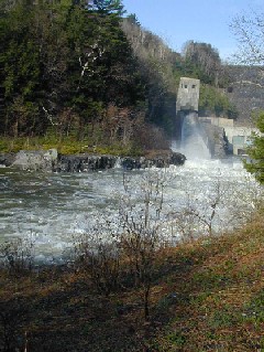
Quechee State Park is located along the river near the village of Quechee. Near the river's mouth the U.S. Army Corps of Engineers' North Hartland Dam impounds the river to form North Hartland Lake.[3]
Near the state park, the river flows through the 165-foot-deep (50 m) Quechee Gorge. The U.S. Rt. 4 bridge crosses over the gorge and provides good viewing down into its depths.
In late August 2011, Hurricane Irene swept through the Ottauquechee River watershed, raising the water level in the river to far beyond its normal height. Houses and towns along the river were devastated.
Variant names and spellings
The U.S. Board on Geographic Names settled on "Ottauquechee River" as the stream's name in 1908. According to the Geographic Names Information System, it has also been known historically as:[5]
- Otta Quechee River
- Ottaquechee River
- Ottaqueeche River
- Queechee River
- Queechy River
- Water Quechee River
- Waterchuichi River
- Waterqueechy River
- Waterqueechy
See also
- List of Vermont rivers
References
- U.S. Geological Survey. National Hydrography Dataset high-resolution flowline data. The National Map, accessed April 1, 2011
- Columbia Gazetteer of North America entry
- DeLorme (1996). Vermont Atlas & Gazetteer. Yarmouth, Maine: DeLorme. ISBN 0-89933-016-9
- U.S. Geological Survey Geographic Names Information System: North Branch Ottauquechee River
- U.S. Geological Survey Geographic Names Information System: Ottauquechee River
External links
![]() Media related to Ottauquechee River at Wikimedia Commons
Media related to Ottauquechee River at Wikimedia Commons
На других языках
[de] Ottauquechee River
Der Ottauquechee River ist ein linker Nebenfluss des Connecticut River im US-Bundesstaat Vermont.- [en] Ottauquechee River
[ru] Оттаквичи
Оттаквичи (англ. Ottauquechee River) — река в штате Вермонт, США. До 1908 года река носила наименование Отта-Квичи или Квичи. Последнее название употребляется и сегодня среди местного населения[1].Другой контент может иметь иную лицензию. Перед использованием материалов сайта WikiSort.org внимательно изучите правила лицензирования конкретных элементов наполнения сайта.
WikiSort.org - проект по пересортировке и дополнению контента Википедии