geo.wikisort.org - River
Netherton Tunnel Branch Canal, in the West Midlands county, England, is part of the Birmingham Canal Navigations, (BCN). It was constructed at a 453–foot elevation, the Wednesbury or Birmingham level; it has no locks. The total length of the branch canal is 2.4 miles (3.9 km) and the canal tunnel is 9,081 feet (2,768 m) long.
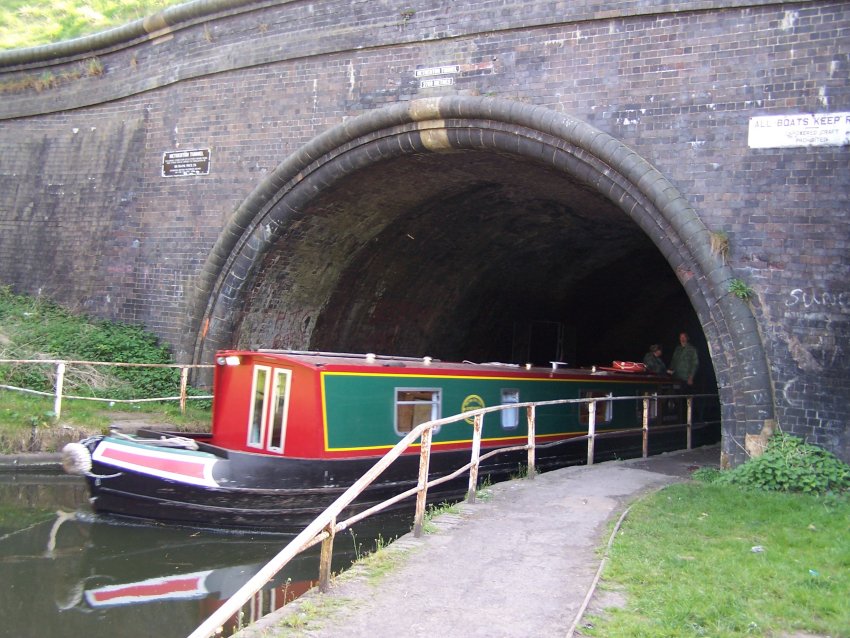 Netherton Tunnel North Portal in use 2007 | |
| Overview | |
|---|---|
| Coordinates | 52.50435°N 2.05932°W |
| Status | Open |
| Waterway | Birmingham Canal Navigations |
| Start | 52.51534°N 2.04948°W |
| End | 52.49335°N 2.06916°W |
| Operation | |
| Constructed | 1855–1858 |
| Opened | 20 August 1858 |
| Owner | Canal and River Trust |
| Technical | |
| Length | 9,081 feet (2,768 m) |
| Tunnel clearance | 16 feet (4.9 m) |
| Width | 27 feet (8.2 m) |
| Towpath | Yes (two) |
| Boat-passable | Yes |

Netherton Tunnel was the last canal tunnel to be built in Britain during the Canal Age. The first sod was turned by the Lord Ward on 31 December 1855 and the canal opened on 20 August 1858, providing a waterway connection between the Black Country towns of Netherton and Tipton. It was built to relieve the bottleneck of the adjacent Dudley Tunnel which is very narrow, has alternating blocks of one-way working, and had waiting times of eight hours or more, and sometimes several days.
The Netherton tunnel was built with a width of 27 feet (8.2 m) to allow two-way working of narrowboats; and is brick lined throughout. It has towpaths running through it, one on each side, which enabled horse-drawn narrowboats to be pulled through it. Chainage (distance) markers are still visible on the Eastern wall. The tunnel was fitted, from the start, with gas lighting over the towpaths, though this was later converted to electricity and it is now unlit.
The air vents that run along the line of the tunnel and provide ventilation, and a shaft of light into the canal, are known by the locals as "pepper pots", because of their shape. They are brick-lined and the openings are covered by an iron frame or grill. The wide bore and good ventilation mean that boats using the tunnel today are allowed to use the power of their internal combustion engines, which is prohibited in the narrower Dudley Tunnel.
The tunnel cost £302,000 as opposed to the £238,000 estimate prior to construction. The main reason for the project being overbudget was the extra works necessitated by the condition of the ground through which the tunnel passes.[1]
Repairs
In 1983, the British Waterways Board had 80 yards (73.2 m) of the brick invert replaced with concrete as a result of the invert rising sufficiently to impede navigation.[2]
In 2011, significant cracks were found in part of the tunnel lining.[3] Traffic through the tunnel was limited, as a result.[3] Repair work began early in 2013.[4]
Route
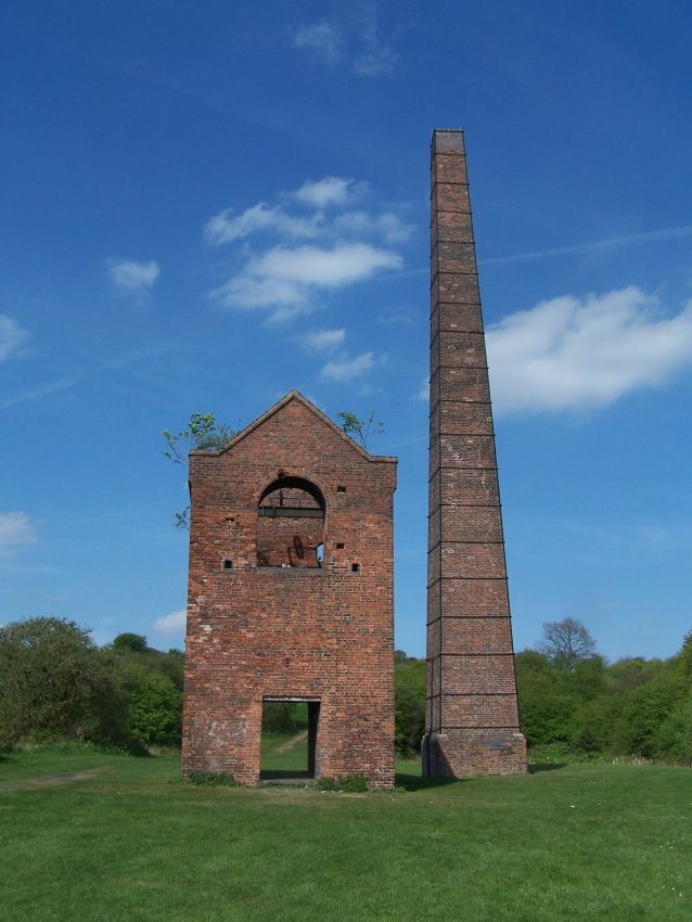
The canal runs south-west from the BCN New Main Line at Dudley Port Junction and under the Old Main Line at Tividale Aqueduct. The northern mouth of the tunnel is near Dudley Road West, close to Tipton's border with Oldbury. An air-vent stands in the middle of Aston Road; another stands between two houses in Regent Road, both in the Tividale Hall estate near Dudley. The southern mouth of the tunnel is in Warrens Hall Park on the border of Dudley and Rowley Regis - the Bumble Hole and Cobb's Engine House are nearby. The Bumble Hole is a landscaped man made lake on the site of a former clay pit. The Dudley No. 2 Canal and the Boshboil Canal Arm are joined at Windmill End Junction. The Boshboil Arm was once part of a loop of the original Dudley Canal which went around Bumble Hole. This loop ceased to be part of the main line when a more direct line was cut. The loop became severed into two arms as a result of subsidence. The northern arm is the Boshboil Arm the southern is the Bumble Hole Branch.
Features
| Netherton Tunnel Branch Canal (distances in miles) | |||||||||||||||||||||||||||||||||||||||||||||||||||||||
|---|---|---|---|---|---|---|---|---|---|---|---|---|---|---|---|---|---|---|---|---|---|---|---|---|---|---|---|---|---|---|---|---|---|---|---|---|---|---|---|---|---|---|---|---|---|---|---|---|---|---|---|---|---|---|---|
| |||||||||||||||||||||||||||||||||||||||||||||||||||||||
| Point | Coordinates (links to map & photo sources) |
|---|---|
| Dudley Port Junction | 52.52204°N 2.04331°W |
| Groveland Bridge (Tipton Road, A457) | 52.51758°N 2.04760°W |
| Tividale Aqueduct (Old BCN Main Line) | 52.51640°N 2.04843°W |
| Northern tunnel portal | 52.51534°N 2.04948°W |
| Air vent No. 16 | 52.512436°N 2.052015°W |
| Packwood Road Air vent (No. 14) | 52.50986°N 2.054329°W |
| Aston Road air vent | 52.50850°N 2.05518°W |
| Regent Road air vent | 52.50697°N 2.05708°W |
| Approx. tunnel midpoint | 52.50435°N 2.05932°W |
| Air vent No. 8 | 52.504191°N 2.059364°W |
| Air vent No. 6 | 52.501551°N 2.061764°W |
| Air vent No. 4 | 52.499036°N 2.064032°W |
| Air vent No. 2 | 52.496345°N 2.066459°W |
| Southern tunnel portal | 52.49335°N 2.06916°W |
| Windmill End Junction | 52.49157°N 2.07019°W |
Gallery
 Cobb's Engine House near the southern portal
 Netherton Tunnel inside northern portal showing the dual towpath
 Slippage in the roof of a southern end of the tunnel, caused by the 2002 Dudley earthquake
 Netherton Tunnel northern portal
 Tividale Aqueduct with old turbine which once generated electricity to illuminate the tunnel
 Tividale Aqueduct and Netherton Tunnel northern portal
 Canal cottages on the branch at Tividale Aqueduct


See also
- List of canal tunnels in the United Kingdom
References
- Roger Cragg, 1997. Wales and West Central England: Wales and West Central England, 2nd Edition. Thomas Telford (ISBN 0-7277-2576-9)
- "Repairers wary in Netherton heaving invert", New Civil Engineer, 1983, 30 June.
- "Netherton canal tunnel 'on the move'". BBC Online. 4 December 2012. Retrieved 8 February 2013.
- "Repairing the 'M6 of the waterways'". BBC Online. 8 February 2013. Retrieved 8 February 2013.
Further reading
- Hadfield, Charles (1969). The Canals of the West Midlands (Second ed.). David & Charles. ISBN 0-7153-4660-1.
- Perrott, David; Mosse, Jonathan (2006). Nicholson Waterways Guide 2 - Severn, Avon & Birmingham. Collins. ISBN 978-0-00-721110-4.
- Palmer, Marilyn (1994). Industry in the Landscape (First ed.). Routledge. p. 189. ISBN 0-415-11206-0.
External links
- Shead, Jim Netherton Tunnel Branch Canal
- Shead, Jim Netherton Tunnel Branch Canal History
Другой контент может иметь иную лицензию. Перед использованием материалов сайта WikiSort.org внимательно изучите правила лицензирования конкретных элементов наполнения сайта.
WikiSort.org - проект по пересортировке и дополнению контента Википедии