geo.wikisort.org - River
The Lewis River is an 18.1-mile-long (29.1 km)[2] tributary of the Snake River. The entire course of the river is located within the boundaries of Yellowstone National Park in Wyoming, US.[3] The river is named for Meriwether Lewis, commander of the Lewis and Clark Expedition.[4]
| Lewis River | |
|---|---|
 | |
| Location | |
| Country | United States |
| State | Wyoming |
| Physical characteristics | |
| Source | |
| • location | Shoshone Lake, Yellowstone National Park, Wyoming |
| • coordinates | 44°21′19″N 110°39′54″W[1] |
| Mouth | Snake River |
• location | Yellowstone National Park, Wyoming |
• coordinates | 44°08′32″N 110°39′49″W[1] |
| Length | 18 mi (29 km)[2] |
The Lewis River begins at the southern end of Shoshone Lake and flows southerly approximately 3 miles (5 km) to Lewis Lake. This short stretch of the river is the only portion of the river where boating is permitted. The river reemerges at the southern end of Lewis Lake and flows in a general southerly direction through a steep canyon roughly paralleling the south entrance road toward the south entrance of the park. Below Lewis Lake the river passes over several cascades and waterfalls including Lewis Falls. Shortly before leaving the park, the Lewis River merges with the Snake River, changing the course of the Snake southward. The Snake soon flows out of Yellowstone into Grand Teton National Park and Jackson Lake.
The Lewis River has rapids up to Class VI and takes a 29-foot (8.8 m) drop at Lewis Falls, the most famous of many waterfalls and rapids on this short but scenic river.
Brown, rainbow and Yellowstone cutthroat trout are found in the river.
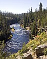 Lewis River
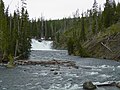 Lewis Falls


See also
- Fishes of Yellowstone National Park
- Heart River
References
- U.S. Geological Survey Geographic Names Information System: Lewis River, USGS GNIS
- U.S. Geological Survey. National Hydrography Dataset high-resolution flowline data. The National Map Archived March 29, 2012, at the Wayback Machine, accessed May 4, 2011
- "USGS Lewis Canyon (WY) Topo Map" (Map). TopoQuest USGS Quads. Retrieved June 29, 2008.
- "Lewis River". wyomingplaces.org. Archived from the original on 2016-03-04. Retrieved 2008-12-13.
Yellowstone National Park - Cascade Corner | ||
|---|---|---|
Rivers, Waterfalls, Peaks and Lakes in the Cascade Corner (Southwest) section of the park | ||
| Rivers |  | |
| Waterfalls and Cascades | ||
| Lakes and Peaks | ||
| ||
На других языках
- [en] Lewis River (Wyoming)
[ru] Льюис (приток Снейка)
Льюис (англ. Lewis River) — река в штате Вайоминг, США; правый приток реки Снейк. На всём своём протяжении протекает по территории национального парка Йеллоустон. Длина составляет 29,1 км. Река названа в честь Мериуэзера Льюиса, американского первопроходца, руководителя экспедиции Льюиса и Кларка.Другой контент может иметь иную лицензию. Перед использованием материалов сайта WikiSort.org внимательно изучите правила лицензирования конкретных элементов наполнения сайта.
WikiSort.org - проект по пересортировке и дополнению контента Википедии