 1974
1974
geo.wikisort.org - River
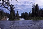
Bechler Falls ht. 15 feet (4.6 m) is a waterfall on the Bechler River in Yellowstone National Park. Bechler Falls is the last waterfall on the Bechler River and is approximately 1 mile (1.6 km) from the confluence with the Fall River. It can be reached via the Bechler River trail approximately 3.5 miles (5.6 km) from the Cave Falls trailhead at the south boundary of the park. The falls were named in 1921 by explorers E. C. Gregg and C.H. Birdseye.[2]
Images of Bechler Falls

| Bechler Falls | |
|---|---|
 1964 | |
| Location | Yellowstone National Park, Teton County, Wyoming |
| Coordinates | 44°08′57″N 111°00′36″W[1] |
| Type | Cascade, block |
| Total height | 15 feet (4.6 m) |
| Watercourse | Bechler River |
See also
- Waterfalls in Yellowstone National Park
Notes
- "Bechler River". Geographic Names Information System. United States Geological Survey.
- Whittlesey, Lee (1996). Yellowstone Place Names. Gardiner, MT: Wonderland Publishing Company. p. 47. ISBN 1-59971-716-6.
Yellowstone National Park - Cascade Corner | ||
|---|---|---|
Rivers, Waterfalls, Peaks and Lakes in the Cascade Corner (Southwest) section of the park | ||
| Rivers |  | |
| Waterfalls and Cascades | ||
| Lakes and Peaks | ||
| ||
Cheyenne (capital) | ||
| Topics |
|  Seal of Wyoming |
| Society |
| |
| Regions |
| |
| Cities |
| |
| Counties | ||
This Wyoming-related article is a stub. You can help Wikipedia by expanding it. |
Текст в блоке "Читать" взят с сайта "Википедия" и доступен по лицензии Creative Commons Attribution-ShareAlike; в отдельных случаях могут действовать дополнительные условия.
Другой контент может иметь иную лицензию. Перед использованием материалов сайта WikiSort.org внимательно изучите правила лицензирования конкретных элементов наполнения сайта.
Другой контент может иметь иную лицензию. Перед использованием материалов сайта WikiSort.org внимательно изучите правила лицензирования конкретных элементов наполнения сайта.
2019-2026
WikiSort.org - проект по пересортировке и дополнению контента Википедии
WikiSort.org - проект по пересортировке и дополнению контента Википедии