geo.wikisort.org - River
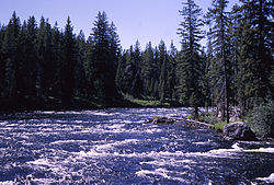
The Bechler River is a remote major river flowing southwest entirely within the confines of Yellowstone National Park to its confluence with the Fall River in the southwest section of the park. The river was named by Frank Bradley, a member of the 1872 Hayden Geological Survey for cartographer and explorer Gustavus R. Bechler, the chief surveyor and mapmaker on the survey. Henry Gannett also a member of the survey claimed that Bechler discovered the river, but trapper Osborne Russell explored the area in 1830.[2]
| Bechler River | |
|---|---|
 Bechler River | |
| Physical characteristics | |
| Source | |
| • location | Trischman Knob |
| • coordinates | 44°17′21″N 110°53′35″W[1] |
| • elevation | 6,306 feet (1,922 m)[1] |
| Mouth | |
• location | Fall River |
• coordinates | 44°08′54″N 110°59′49″W[1] |
| Basin features | |
| Tributaries | |
| • left | Ferris Fork, Littler Fork |
| • right | Boundary Creek, Ouzel Creek, Phillips Fork, Gregg Fork |
Waterfalls
The Bechler River is located in the remote southwest part of the park known as Cascade Corner, named by Superintendent Horace Albright in 1921 for the abundance of waterfalls and cascades in the Fall and Bechler River drainages. Several major Yellowstone waterfalls exist in the Bechler River watershed:[3]
- Albright Falls, 260 feet (79 m), 44°16′40″N 110°54′13″W[4]
- Bechler Falls, 15 feet (4.6 m),44°08′57″N 111°00′36″W[5]
- Colonnade Falls, 44°14′19″N 110°56′53″W[6]
- Upper 35 feet (11 m)
- Lower 67 feet (20 m)
- Dunanda Falls, 150 feet (46 m), 44°14′52″N 111°01′27″W[7]
- Gwinna Falls, 15 feet (4.6 m), 44°16′55″N 110°52′49″W[8]
- Iris Falls, 45 feet (14 m), 44°14′30″N 110°56′37″W[9]
- Ouzel Falls, 230 feet (70 m), 44°14′06″N 110°58′33″W[10]
- Quiver Cascade, 98 feet (30 m), 44°18′18″N 110°52′53″W[11]
- Ragged Falls, 45 feet (14 m), 44°17′17″N 110°53′24″W[12]
- Tempe Cascade, 30 feet (9.1 m), 44°18′06″N 110°52′14″W[13]
- Twister Falls, 55 feet (17 m),44°17′51″N 110°51′43″W[14]
- Wahhi Falls, 44°16′31″N 110°52′40″W[15]
- Upper 28 feet (8.5 m)
- Lower 18 feet (5.5 m)
Angling
Although the Bechler River is in the remote Cascade Corner of the park, it is popular with local anglers. It holds mostly cutthroat trout and a few rainbow trout. Because of spring runoff, the river is generally not fishable until mid-July and access is difficult.[16][17] The river is paralleled by the Bechler River Trail which starts at Cave Falls on the park's south boundary or spurs off the Shoshone Lake trail.
Notes
- "Bechler River". Geographic Names Information System. United States Geological Survey.
- Whittlesey, Lee (1996). Yellowstone Place Names. Wonderland Publishing Company Gardiner, MT. p. 47. ISBN 1-59971-716-6.
- Whittlesey, Lee (1996). Yellowstone Place Names. Wonderland Publishing Company Gardiner, MT. pp. 61–62. ISBN 1-59971-716-6.
- "Albright Falls". Geographic Names Information System. United States Geological Survey.
- "Bechler River". Geographic Names Information System. United States Geological Survey.
- "Colonnade Falls". Geographic Names Information System. United States Geological Survey.
- "Dunanda Falls". Geographic Names Information System. United States Geological Survey.
- "Gwinna Falls". Geographic Names Information System. United States Geological Survey.
- "Iris Falls". Geographic Names Information System. United States Geological Survey.
- "Ouzel Falls". Geographic Names Information System. United States Geological Survey.
- "Quiver Cascade". Geographic Names Information System. United States Geological Survey.
- "Ragged Falls". Geographic Names Information System. United States Geological Survey.
- "Tempe Cascade". Geographic Names Information System. United States Geological Survey.
- "Twister Falls". Geographic Names Information System. United States Geological Survey.
- "Wahhi Falls". Geographic Names Information System. United States Geological Survey.
- Parks, Richard (1998). Fishing Yellowstone National Park. Helena, MT: Falcon Press. ISBN 1-56044-625-0.
- Mathews, Craig; Molinero, Clayton (1997). The Yellowstone Fly-Fishing Guide—An authoritative guide to the waters of Yellowstone National Park. Guilford, CT: The Lyons Press. ISBN 1-55821-545-X.
На других языках
[de] Bechler River
Der Bechler River ist ein abgelegener Fluss, der vollständig innerhalb der Grenzen des Yellowstone-Nationalparks im US-Bundesstaat Wyoming liegt. Bis zum Zusammenfluss mit dem Fall River im südwestlichen Teil des Parks fließt er nach Südwesten. Benannt wurde der Fluss von Frank Bradley, einem Mitglied des Hayden Geological Survey 1872 nach dem Kartographen und Entdecker Gustavus R. Bechler. Henry Gannett, ein Mitglied der Expedition, behauptete, dass Bechler den Fluss entdeckte, aber der Trapper Osborne Russell erkundete das Gebiet bereits 1830.[1]- [en] Bechler River
Другой контент может иметь иную лицензию. Перед использованием материалов сайта WikiSort.org внимательно изучите правила лицензирования конкретных элементов наполнения сайта.
WikiSort.org - проект по пересортировке и дополнению контента Википедии

