geo.wikisort.org - River
The Hundru Falls is a waterfall located in Ranchi district in the Indian state of Jharkhand. It is the 34th highest waterfall in India.[3] It is one of the most famous tourist places in the region.[4]
| Hundru Falls | |
|---|---|
 | |
 | |
| Location | Ranchi district, Jharkhand, India |
| Coordinates | 23.4500°N 85.6500°E[1] |
| Type | Segmented |
| Elevation | 456 metres (1,496 ft)[2] |
| Total height | 98 metres (322 ft) |
| Watercourse | Subarnarekha River |
Geography
M: municipality, CT: census town, R: rural/ urban centre, N: neighbourhood, T: tourist centre, D: dam, H: historical/ religious centre
Owing to space constraints in the small map, the actual locations in a larger map may vary slightly
Location
Hundru Falls is located at 23.4500°N 85.6500°E
Note: The map alongside presents some of the notable locations in the district. All places marked in the map are linked in the larger full screen map.
The falls
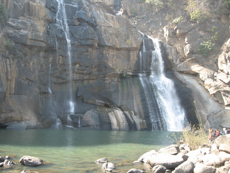
On the course of the Subarnarekha River, where it falls from a height of 98 metres (322 ft) creating one of the highest water falls in the state. The spectacular scene of water fallit height has been described as a sight to behold. The different formations of rock due to the erosion by the constantly falling of water have added to the beauty of the place.[5][6][7]
The Hundru Falls at one of the edges of the Ranchi plateau is one of the several scarp falls in the region.[8] During rainy season it takes a formidable form but in the dry season it turns into an exciting picnic spot.[9] At the base of the Hundru Falls, there is a pool, which serves as a bathing place.[5]
The Hundru Falls is an example of a Knick point caused by rejuvenation. Knickpoint, also called a nick point or simply nick, represents breaks in slopes in the longitudinal profile of a river caused by rejuvenation. The break in channel gradient allows water to fall vertically giving rise to a waterfall.[10]
Transport
One has to travel some about 21 kilometres (13 mi) from the main road, Purulia Road.[7][11]
There is also a shortcut and simple four-lane road from Ranchi via Ormanjhi via Sikidiri to Hundru. From this road the distance is about 39 kilometres (24 mi) which is about 6 kilometres (3.7 mi) short from the normal road.
There is also a Suvarna Rekha Hydral Project located down the falls which is also a good place for Tourists.[7]
See also
- List of waterfalls in India
- List of waterfalls in India by height
 Ranchi travel guide from Wikivoyage
References
- "Hundru, India Page". Falling Rain Genomics. Retrieved 20 April 2010.
- "Hundru, State Of Jharkhand, India". travelsradiate.com. Retrieved 12 February 2012.
- "Showing all Waterfalls in India". World Waterfalls Database. Archived from the original on 5 September 2012. Retrieved 20 June 2010.
- "Jharkhand Tourism | Major Destinations and Attraction | How to Reach". Travel News India. 7 August 2016. Retrieved 24 February 2017.
- "Hundru Falls Ranchi". Maps of India. Retrieved 20 April 2010.
- "The other side of this industrial city". The Hindu Business Line, 28 July 2003. Retrieved 20 April 2010.
- "Hundru Falla". District administration. Retrieved 20 April 2010.
- Bharatdwaj, K. (2006). Physical Geography: Hydrosphere By K. Bharatdwaj. ISBN 9788183561679. Retrieved 20 April 2010.
- "Places of interest". Archived from the original on 6 April 2011. Retrieved 20 April 2010.
- A.Z.Bukhari (2005). Encyclopedia of nature of geography. p. 110. ISBN 9788126124435. Retrieved 11 July 2010.
- Sir John Houlton, Bihar, the Heart of India, p. 144, Orient Longmans, 1949
This article related to a location in Jharkhand is a stub. You can help Wikipedia by expanding it. |
Другой контент может иметь иную лицензию. Перед использованием материалов сайта WikiSort.org внимательно изучите правила лицензирования конкретных элементов наполнения сайта.
WikiSort.org - проект по пересортировке и дополнению контента Википедии