geo.wikisort.org - River
The Fium'Alto (or Fium'Altu) is a small coastal river in the department of Haute-Corse, Corsica, France.
| Fium'Alto | |
|---|---|
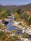
 Fium'Alto from the Acitaja bridge in Penta di Cassinca (Folelli) | |
 Course of the Fium'Alto | |
| Native name | Fium'Altu (Corsican) |
| Location | |
| Country | France |
| Region | Corsica |
| Department | Haute-Corse |
| Physical characteristics | |
| Mouth | Tyrrhenian Sea |
• coordinates | 42.4399°N 9.5413°E |
Course

The Fium'Alto is 30.81 kilometres (19.14 mi) long. It crosses the communes of Carcheto-Brustico, Casalta, Croce, Ficaja, Monacia-d'Orezza, Penta-di-Casinca, Piano, Piazzole, Piedicroce, Piedipartino, Pie-d'Orezza, Porri, La Porta, Pruno, Rapaggio, Scata, Stazzona, San-Damiano, San-Gavino-d'Ampugnani and Taglio-Isolaccio.[1]
The Fium'Alto rises to the south of the 1,767 metres (5,797 ft) Monte San Petrone in the commune of Pie d'Orezza. It flows southeast past the village of Pie d'Orezza, east past Piedicroce and Stazzona, then generally north and east to the town of Folelli (Penta-di-Casinca) and the sea. The D71 road follows the upper part of the river, and then the D506 follows it for the remainder of its course.[2]
Hydrology
Measurements of the river flow were taken at the Taglio-Isolaccio Acitaja station from 1960 to 2021. The watershed above this station covers 114 square kilometres (44 sq mi). Annual precipitation was calculated as 383 millimetres (15.1 in). The average flow of water throughout the year was 1.38 cubic metres per second (49 cu ft/s).[3]
| Month | Flow |
|---|---|
| Jan | 2.220 |
| Feb | 2.420 |
| Mar | 2.580 |
| Apr | 2.130 |
| May | 1.400 |
| Jun | 0.722 |
| Jul | 0.387 |
| Aug | 0.270 |
| Sep | 0.373 |
| Oct | 0.781 |
| Nov | 1.490 |
| Dec | 1.860 |
Tributaries
The following streams (ruisseaux) are tributaries of the Bravone (ordered by length) and sub-tributaries:[1]
- Pozzo Bianco 7 km (4.3 mi)
- Molaghina 3 km (1.9 mi)
- Arche 3 km (1.9 mi)
- Cagnolo et de Teja 3 km (1.9 mi)
- Lavatoio et de Noceta 2 km (1.2 mi)
- Terciola 1 km (0.62 mi)
- Penta 1 km (0.62 mi)
- Arche 3 km (1.9 mi)
- Forcione 3 km (1.9 mi)
- Porcili 1 km (0.62 mi)
- Chiarello 2 km (1.2 mi)
- Funtana 1 km (0.62 mi)
- Alzeta 1 km (0.62 mi)
- Vetuste 1 km (0.62 mi)
- Molaghina 3 km (1.9 mi)
- Andegno 5 km (3.1 mi)
- Verbicina 3 km (1.9 mi)
- Mustaco 3 km (1.9 mi)
- Pollace 2 km (1.2 mi)
- Acquanili 1 km (0.62 mi)
- Nicchiosa 1 km (0.62 mi)
- Rossi 1 km (0.62 mi)
- Polveroso 5 km (3.1 mi)
- San Pancrazio 5 km (3.1 mi)
- San Fiumento 3 km (1.9 mi)
- Tigliola 3 km (1.9 mi)
- Lavatoghio 1 km (0.62 mi)
- Falongo 1 km (0.62 mi)
- Tigliola 3 km (1.9 mi)
- San Fiumento 3 km (1.9 mi)
- Croce 1 km (0.62 mi)
- Funtana Maio 1 km (0.62 mi)
- San Pancrazio 5 km (3.1 mi)
- Migliarine 4 km (2.5 mi)
- Isola 3 km (1.9 mi)
- Palatina 1 km (0.62 mi)
- Carpinete 1 km (0.62 mi)
- Chiaraggio 3 km (1.9 mi)
- Ortale 1 km (0.62 mi)
- Piedipartino 3 km (1.9 mi)
- Rustaggio 3 km (1.9 mi)
- Volta 3 km (1.9 mi)
- Porri 1 km (0.62 mi)
- Onda 3 km (1.9 mi)
- Fioraccio 3 km (1.9 mi)
- Somerino 2 km (1.2 mi)
- San Marcello 1 km (0.62 mi)
- Somerino 2 km (1.2 mi)
- Scaffone 3 km (1.9 mi)
- La Foata 3 km (1.9 mi)
- Navacchi 2 km (1.2 mi)
- Piazzi 2 km (1.2 mi)
- Rividaldo 2 km (1.2 mi)
- Piano 2 km (1.2 mi)
- Acqua Riola 2 km (1.2 mi)
- Padulelle 2 km (1.2 mi)
- Falasco 2 km (1.2 mi)
- Cogno Lello 1 km (0.62 mi)
- Onda al Diavole 1 km (0.62 mi)
- Finosa 1 km (0.62 mi)
- Acqua Merla 1 km (0.62 mi)
- Aja a e Calle 1 km (0.62 mi)
- Aja Alle Porte 1 km (0.62 mi)
- Colombino 1 km (0.62 mi)
- Mugliani 1 km (0.62 mi)
- Forcione 1 km (0.62 mi)
- Suare Calle 1 km (0.62 mi)
- Campo d'Arietto 1 km (0.62 mi)
- Padule 1 km (0.62 mi)
- Trovoli 1 km (0.62 mi)
- Aja Rossa 1 km (0.62 mi)
- Pisciancone 1 km (0.62 mi)
Notes
Sources
- "Le Fium-Alto à Taglio-Isolaccio [Acitaja]", eaufrance (in French), Ministère de l'Ecologie, du Développement Durable et de l'Energie, retrieved 2021-12-31
- "Le Fium Alto", Sandre (in French), retrieved 2021-12-31
- "Relation: Fium'Alto (7390872)", OpenStreetMap, retrieved 2021-12-31
На других языках
[de] Fium Alto
Der Fium Alto ist ein Fluss in Frankreich, der im Département Haute-Corse auf der Insel Korsika verläuft. Er entspringt in der Landschaft Castagniccia, im Regionalen Naturpark Korsika, im Gemeindegebiet von Pie-d’Orezza, entwässert generell Richtung Ost bis Nordost und mündet nach rund 31 Kilometern an der Gemeindegrenze von Taglio-Isolaccio und Penta-di-Casinca in das Tyrrhenische Meer.- [en] Fium'Alto
[it] Fium'Alto
Il Fium'Alto o Alto (Fiumaltu in còrso) è un fiume della Corsica settentrionale che sfocia nel mar Tirreno.Другой контент может иметь иную лицензию. Перед использованием материалов сайта WikiSort.org внимательно изучите правила лицензирования конкретных элементов наполнения сайта.
WikiSort.org - проект по пересортировке и дополнению контента Википедии


