geo.wikisort.org - River
Betsiboka River is a 525-kilometre (326 mi) long river in central-north Madagascar. It flows northwestward and empties to Bombetoka Bay, forming a large delta. It originates to the east of Antananarivo. The river is surrounded in mangroves.[1] The river is distinctive for its red-coloured water, which is caused by river sediments. The river carries an enormous amount of reddish-orange silt to the sea. Much of this silt is deposited at the mouth of the river or in the bay.
| Betsiboka River | |
|---|---|
 Rapids in the Betsiboka River | |
 Map of Malagasy rivers (Betsiboka flows from the center to the northwestern coast). | |
| Location | |
| Country | Madagascar |
| Region | Boeny |
| City | Mahajanga, Ambato-Boeny |
| Physical characteristics | |
| Mouth | |
• location | Bombetoka Bay, Mozambique Channel |
• coordinates | 15°48′55″S 46°16′13″E |
| Length | 525 km (326 mi) |
| Basin size | 49,000 km2 (19,000 sq mi) |
| Basin features | |
| Tributaries | |
| • left | Ikopa River |
| • right | Kamoro River |
It is dramatic evidence of the catastrophic erosion of northwestern Madagascar.[2] Removal of the native forest for cultivation and pastureland during the past 50 years has led to massive annual soil losses approaching 250 metric tonnes per hectare (112 tons per acre) in some regions of the island, the largest amount recorded anywhere in the world. Several fish species are endemic to the river basin, including the three cichlids Paretroplus petiti, P. tsimoly and P. maculatus.
The Betsiboka's largest tributary, the Ikopa River, drains the capital city of Antananarivo.
 Betsiboka River estuary seen from space
 The Betsiboka River in normal conditions
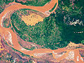 The Betsiboka River when flooded


See also
- Betsiboka Bridge
References
- Bradt, Hilary (17 May 2011). Madagascar: The Bradt Travel Guide. Bradt Travel Guides. p. 82. ISBN 978-1-84162-341-2. Retrieved 8 January 2013.
- Tsilavo Raharimahefa and Timothy M. Kusky (2010). "Environmental monitoring of Bombetoka bay and the Betsiboka estuary, Madagascar, using multi-temporal satellite data". Archived from the original on 2012-12-09.
External links
- Floods in Madagascar[dead link] at NASA Earth Observatory
- Sediment Laden Drainages at Lunar and Planetary Institute, USRA
- NASA: Earth from Space
Authority control | |
|---|---|
| General |
|
| National libraries | |
На других языках
[de] Betsiboka
Der Fluss Betsiboka [.mw-parser-output .IPA a{text-decoration:none}beˈtsibukḁ] im Nordwesten Madagaskars mit einem Wassereinzugsgebiet von 49.000 Quadratkilometern[2], ist 531 Kilometer lang und wird oft auch Roter Fluss genannt.[4] Er mündet in der Bucht von Bombetoka bei der am rechten Ufer liegenden Stadt Mahajanga (französisch Majunga). Er ist einer der drei größten Fluss in Madagaskar.- [en] Betsiboka River
[es] Río Betsiboka
El río Betsiboka es uno de los principales ríos de Madagascar, que discurre por la parte centro-norte y tiene una longitud de 525 km de largo. Fluye hacia el noroeste y desemboca en la bahía de Bombetoka, formando un gran delta. El río se distingue por sus aguas rojizas, causadas por una enorme cantidad de limo de color hasta el mar. Gran parte de estos sedimentos se depositan en la desembocadura del río o en la bahía.[it] Betsiboka (fiume)
Il Betsiboka è un fiume che scorre nel Madagascar nord-occidentale. Origina nei pressi della Falesia dell'Angavo, a 1755 m di altitudine, e sfocia, con un grande delta, nella baia di Bombetoka (Canale del Mozambico), le cui coste ospitano una delle foreste litoranee a mangrovie più estese del Madagascar[1].[ru] Бецибука
Беци́бука[1] или Бецибу́ка[2] (устар. Бетсибока[3] и Бетзибока[4]; малаг. Betsiboka) — река в северо-западной части острова Мадагаскар. Имеет длину 525 км, является крупнейшей рекой острова. Известна своим красно-коричневым цветом, который объясняется огромным количеством седиментов, вымываемых рекой в море.Другой контент может иметь иную лицензию. Перед использованием материалов сайта WikiSort.org внимательно изучите правила лицензирования конкретных элементов наполнения сайта.
WikiSort.org - проект по пересортировке и дополнению контента Википедии