geo.wikisort.org - River
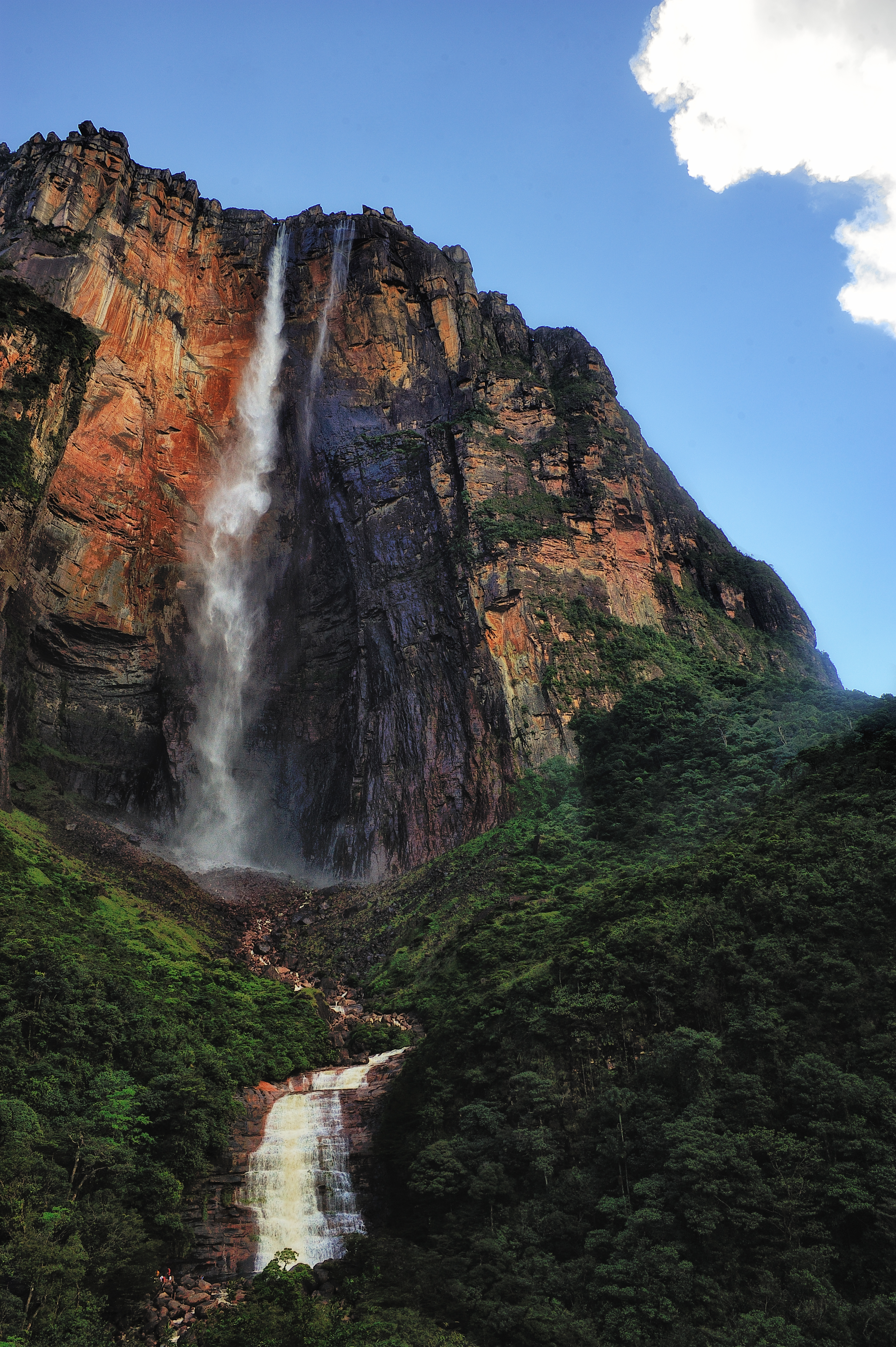
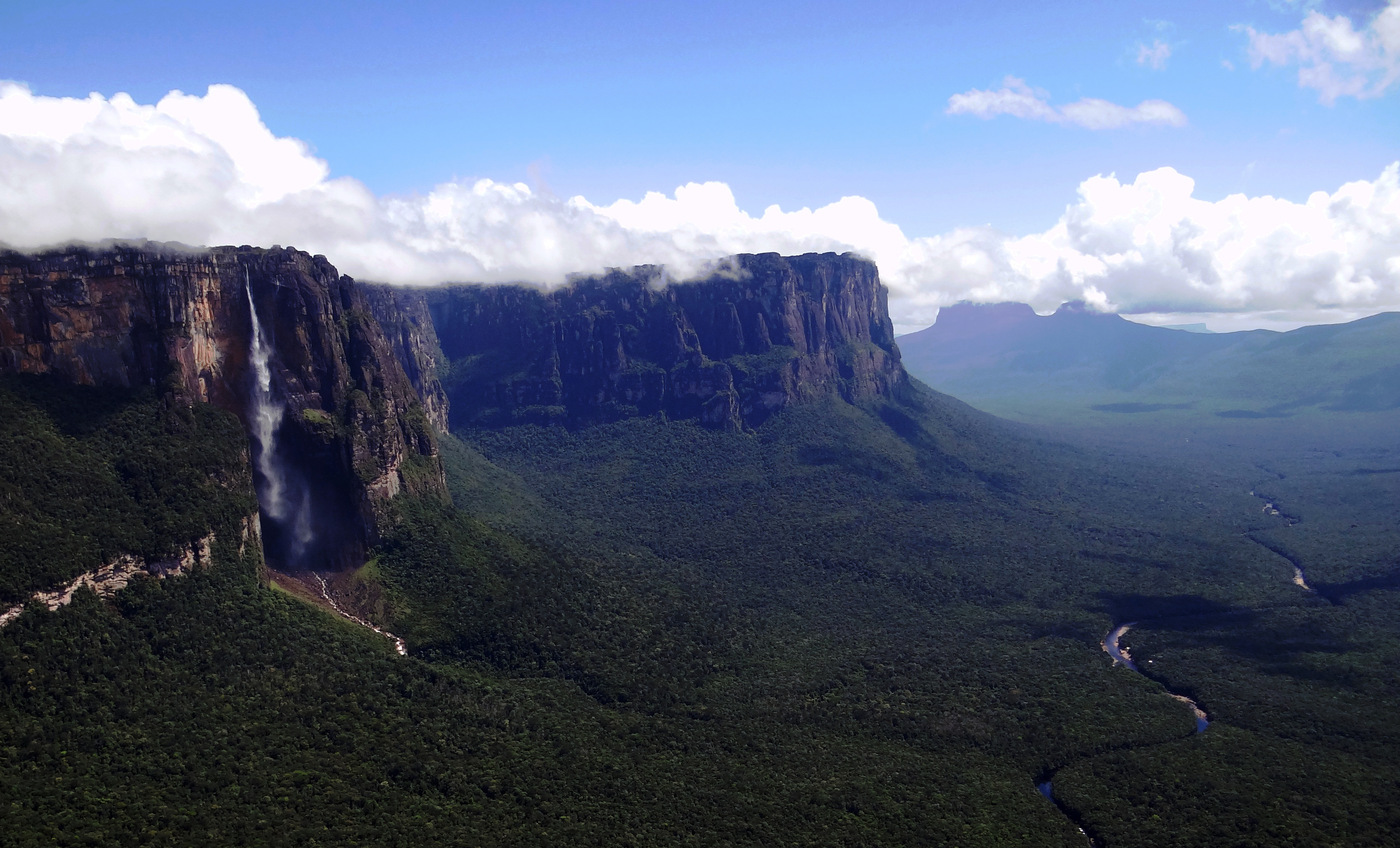
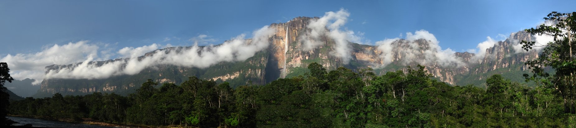
Angel Falls (Spanish: Salto Ángel; Pemon language: Kerepakupai Merú meaning "waterfall of the deepest place", or Parakupá Vená, meaning "the fall from the highest point") is a waterfall in Venezuela. It is the world's tallest uninterrupted waterfall, with a height of 979 metres (3,212 ft) and a plunge of 807 m (2,648 ft). The waterfall drops over the edge of the Auyán-tepui mountain in the Canaima National Park (Spanish: Parque Nacional Canaima), a UNESCO World Heritage site in the Gran Sabana region of Bolívar State. The height figure, 979 m (3,212 ft), mostly consists of the main plunge but also includes about 400 metres (1,300 ft) of sloped cascade and rapids below the drop and a 30-metre-high (100 ft) plunge downstream of the talus rapids.
| Angel Falls | |
|---|---|
| Salto Ángel Kerepakupai Vená | |
 Angel Falls, Bolívar State, Venezuela | |
 Location in Venezuela | |
 | |
| Location | Auyán-tepui, Canaima National Park, Bolívar State, Venezuela |
| Coordinates | 5°58′03″N 62°32′08″W |
| Type | Plunges |
| Total height | 979 m (3,212 ft) |
| Number of drops | 2 |
| Longest drop | 807 m (2,648 ft) |
| World height ranking | 1st[1] |
The falls are along a fork of the Río Kerepacupai Merú which flows into the Churún River, a tributary of the Carrao River, itself a tributary of the Orinoco River.
History
Etymology
The waterfall has been known as Angel Falls since the mid-20th century; they are named after Jimmie Angel, a U.S. aviator, who was the first person to fly over the falls.[2] Angel's ashes were scattered over the falls on 2 July 1960.[3]
The common Spanish name Salto Ángel derives from his surname. In 2009, President Hugo Chávez announced his intention to change the name to the purported original indigenous Pemon term ("Kerepakupai-Merú", meaning "waterfall of the deepest place"), on the grounds that the nation's most famous landmark should bear an indigenous name.[4] Explaining the name change, Chávez was reported to have said, "This is ours, long before Angel ever arrived there ... this is indigenous land."[5] However, he later said that he would not decree the change of name, but was only defending the use of Kerepakupai Vená.[6]
Exploration
Sir Walter Raleigh, in his expedition to find the fabled city of El Dorado, described what was possibly a tepui (table top mountain), and he is said to have been the first European to view Angel Falls, although these claims are considered far-fetched.[7] Some historians state that the first European to visit the waterfall was Fernando de Berrío, a Spanish explorer and governor from the 16th and 17th centuries.[8] Other sources state that the first Westerner to see the waterfall was the Spanish explorer Fèlix Cardona in 1927.[9]
They were not known to the outside world until American aviator Jimmie Angel, following directions given by Cardona, flew over them on 16 November 1933 on a flight while he was searching for a valuable ore bed.[9][10][11]
Returning on 9 October 1937, Angel tried to land his Flamingo monoplane El Río Caroní atop Auyán-tepui, but the plane was damaged when the wheels sank into the marshy ground. Angel and his three companions, including his wife Marie, were forced to descend the tepui on foot. It took them 11 days to make their way back to civilization by the gradually sloping back side, but news of their adventure spread and the waterfall was named Angel Falls in his honor. The name of the waterfall—"Salto del Ángel"—was first published on a Venezuelan government map in December 1939.[12]
Angel's plane remained on top of the tepui for 33 years before being lifted out by helicopter.[13] It was restored at the Aviation Museum in Maracay and now sits outdoors on the front of the airport at Ciudad Bolívar.
The first recorded European to reach the base of the falls was the Latvian explorer Aleksandrs Laime, also known as Alejandro Laime to the native Pemon tribe. He reached the falls alone in 1946. He was the first to reach the upper side of the falls in the late 1950s, by climbing up the back side, where the slope is not vertical.[14] He also reached Angel's plane 18 years after the crash landing. On 18 November 1955, Latvian independence day, he announced to the Venezuelan newspaper El Nacional that this stream without any known local name should be named after a Latvian river, Gauja. The same year, this name was registered in the National Cartographic Institution of Venezuela. There is no convincing proof that the indigenous Pemon people had named the local streams, as Auyán-tepui was considered to be a dangerous place and was not visited by the indigenous people.[14] However, lately the Pemon name Kerep is used as well.
Laime was also the first to clear a trail that leads from the Churún River to the base of the falls. On the way is a viewpoint commonly used to capture the falls in photographs. It is named Mirador Laime ("Laime's Viewpoint" in Spanish) in his honor. This trail is used now mostly for tourists, to lead them from the Isla Ratón camp to the small clearing.
The official height of the falls was determined by a survey carried out by an expedition organized and financed by American journalist Ruth Robertson on 13 May 1949.[12][15] Robertson's expedition, which began on 23 April 1949, was also the first to reach the foot of the falls.[16] The first known attempt to climb the face of the cliff was made in 1968 during the wet season. It failed because of slippery rock. In 1969, a second attempt was made during the dry season. This attempt was thwarted by lack of water and an overhang 120 metres (400 ft) from the top. The first climb to the top of the cliff was completed on 13 January 1971. The climbers, a four-man team led by American mountaineer George Bogel, an electrical engineer from Pittsburgh, Pennsylvania, required nine and a half days to ascend and one and a half days to rappel down.[17][18]
Tourism
Angel Falls is one of Venezuela's top tourist attractions, though a trip to the falls is a complicated affair. The falls are located in an isolated jungle. A flight from Maiquetia Airport or Puerto Ordaz or Ciudad Bolívar is required to reach Canaima camp, the starting point for river trips to the base of the falls. River trips generally take place from June to December, when the rivers are deep enough for use by the Pemon guides. During the dry season (December to March), there is less water seen than in the other months.
See also
References
- "Angel Falls". Encyclopædia Britannica. 17 November 2013. Retrieved 22 May 2015.
- "Plane Pilot Sights Highest Waterfall in World". Popular Science: 37. April 1938.
- "The History of Jimmie Angel". Jimmie Angel Historical Project. Archived from the original on 16 March 2010.
- Carroll, Rory (21 December 2009). "Hugo Chávez renames Angel Falls". The Guardian. London. Retrieved 25 April 2010.
- "Venezuela Chavez renames world's tallest waterfall". Thomson Reuters Foundation. 17 September 2011. Archived from the original on 14 January 2010. Retrieved 24 August 2016.
- "Chávez dice que no decretó el cambio de nombre del Salto del Ángel". Noticias24 (in Spanish). Retrieved 22 May 2015.
- "Walter Raleigh – Delusions of Guiana". The Lost World: The Gran Sabana, Canaima National Park and Angel Falls – Venezuela. Archived from the original on 14 October 2002. Retrieved 24 August 2016.
- Valeriano Sánchez Ramos (2005). "Farua: revista del Centro Virgitano de Estudios Históricos". Farua: Revista del Centro Virgitano de Estudios Históricos (8): 105–42. ISSN 1138-4263.
- Casanova_y_Solanas, Eugenio (2013). La conquista del Orinoco.
- "Jimmie Angel ... An Explorer". 25 December 2008. Archived from the original on 5 October 2013. Retrieved 22 May 2015.
- Angel, Karen (2001). "The Truth About Jimmie Angel & Angel Falls". Retrieved 14 November 2009.
- Angel, Karen (April 2012). "Why the World's Tallest Waterfall is Named Angel Falls" (PDF). Terrae Incognitae. 44 (1): 16–42. doi:10.1179/0082288412Z.0000000003. S2CID 129635707. Retrieved 5 March 2013.
- "Rescate de la avioneta de Jimmy Ángel" (in Spanish). 11 July 2013.
- Stavro, Andris (1999). Aleksandrs Laime un viņa zelta upe (1st ed.). ISBN 9984071847.
- Robertson, Ruth (April 2007). "Jungle Journey to the World's Highest Waterfall". In Jenkins, Mark (ed.). Worlds to Explore. National Geographic. ISBN 978-1-4262-0044-1.
- Polk, Milbry; Tiegreen, Mary (2001). Women of Discovery: A Celebration of Intrepid Women who Explored the World. Scriptum Editions. p. 189. ISBN 9781902686172.
- David Nott, Angels Four, Prentice-Hall Inc. 1972 chronicles the first successful climb up the face of Auyantepui to the top of the falls.
- J., Hellman; R., Slone; J., Unkovic (1978). "GEORGE BOGEL 1944-1977". American Alpine Journal. 21 (2): 674.
External links
![]() Media related to Kerepakupai merú (category) at Wikimedia Commons
Media related to Kerepakupai merú (category) at Wikimedia Commons
|
Authority control | |
|---|---|
| General |
|
| National libraries | |
На других языках
[de] Salto Ángel
Der Salto Ángel (nach dem Wiederentdecker Jimmie Angel, auch Salto Churún-Merú) ist ein Wasserfall im Südosten Venezuelas. Er ist mit 979 m Fallhöhe der höchste freifallende Wasserfall der Erde. In der Sprache der indigenen Pemón heißt er Kerepakupai Vena, was etwa Ort des tiefsten Sprunges bedeutet.- [en] Angel Falls
[es] Salto Ángel
El Salto Ángel (en pemón: Kerepakupai vená que significa «salto del lugar más profundo»)[n 1] es la cascada más alta del mundo, con una altura de 979 m (807 m de caída ininterrumpida),[1][2][3] originada en el Auyantepuy. Está ubicado en el parque nacional Canaima, Estado Bolívar, Venezuela. Es un espacio natural protegido, al ser declarado parque nacional el 12 de junio de 1962 y Patrimonio de la Humanidad por la Unesco en 1994,[4] que se extiende sobre un área de más de 30 000 km² (similar a la extensión territorial de Bélgica), hasta la frontera con Brasil y el territorio del Esequibo (actualmente en reclamación).[it] Salto Angel
Il Salto Ángel o Kerepakupai Vená (lingua pemon: Kerepakupai Merú, "la cascata del luogo più profondo", o Parakupá Vená, "la caduta dal punto più alto") è la cascata con la caduta ininterrotta d'acqua più alta al mondo (807 metri), con un dislivello totale (da cima a valle) di 980 metri. Si trova in Venezuela, nel Parque Nacional de Canaima.[ru] Анхель
А́нхель, Керепакупаи-Меру (исп. Kerepakupai Meru[1], исп. Salto Ángel, на пемонском языке — Kerepakupai vena, что значит «Водопад глубочайшего места») — самый высокий водопад в мире, общая высота 979 метров (по другим данным 1054[2] метра), высота непрерывного свободного падения воды 807[3] метров. Находится на реке Кереп в венесуэльском штате Боливар.Другой контент может иметь иную лицензию. Перед использованием материалов сайта WikiSort.org внимательно изучите правила лицензирования конкретных элементов наполнения сайта.
WikiSort.org - проект по пересортировке и дополнению контента Википедии