geo.wikisort.org - Mountains
Auyán Tepui (Spanish pronunciation: [awˈʝan teˈpuj]), also spelled Ayan,[2] is a tepui in Bolívar state, Venezuela.[1] It is the most visited and one of the largest (but not the highest) tepuis in the Guiana Highlands, with a summit area of 666.9 km2 (257.5 sq mi) and an estimated slope area of 715 km2 (276 sq mi).[1] The unevenly heart-shaped summit plateau of Auyán-tepui is heavily inclined, rising from around 1,600 metres (5,200 ft) in the northwest to a maximum of 2,450 m (8,040 ft) in the southeast.[1] It is incised from the north by a vast valley, the Cañón del Diablo (Devil's Canyon), formed by the Churún River. The larger western portion of the plateau is partially forested, whereas the eastern part comprises mostly bare rock with only patchy vegetation cover.[1] The mountain hosts a number of extensive cave systems.[3][4]
| Auyán | |
|---|---|
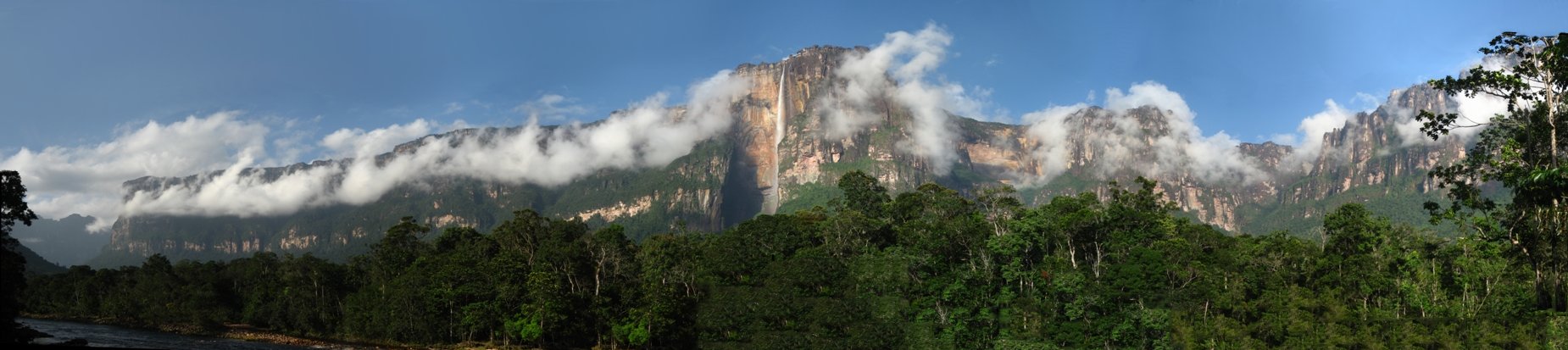
 Auyán Tepui seen at dusk from Campo Uruyen | |
| Highest point | |
| Elevation | 2,450 m (8,040 ft)[1] |
| Coordinates | 05°54′01″N 62°32′29″W |
| Geography | |
 Auyán Location in Venezuela | |
| Location | Bolívar, Venezuela |
Auyán-tepui gives its name to the Auyán Massif, which also includes the tiny peaks of Cerro El Sol and Cerro La Luna to the north, and the satellite mountain of Uaipán-tepui to the south. The massif has a total summit area of roughly 670 km2 (260 sq mi) and an estimated slope area of 795 km2 (307 sq mi).[1] It is situated entirely within the bounds of Canaima National Park.[5] Auyán-tepui means "Devil's House" in the local Pemón language.[6]
Angel Falls, the tallest waterfall in the world, drops from a cleft near the summit. The falls are 979 meters (3,212 ft) high, with an uninterrupted descent of 807 meters (2,648 ft)[7] — a drop nineteen times higher than that of Niagara Falls.
Auyán-tepui achieved international fame in 1933 when Angel Falls was accidentally discovered by Jimmie Angel, a bush pilot searching for gold ore. Attempting to land on the heart-shaped mesa in 1937, Angel crashed his small Flamingo plane on top of Auyán-tepui and was forced to hike down the gradually sloping backside, a trip that took him and his crew 11 days to complete; he was immortalised when the waterfall was named after him.[6]
Around 25 species of amphibians and reptiles are known from the summit plateau of Auyán-tepui,[8][9] as well as numerous birds.[10][11][12][13] Like many tepuis, the mountain hosts a rich assemblage of flora.[14][15]
See also
- Gran Sabana
- Distribution of Heliamphora
References

- Huber, O. (1995). Geographical and physical features. In: P.E. Berry, B.K. Holst & K. Yatskievych (eds.) Flora of the Venezuelan Guayana. Volume 1. Introduction. Missouri Botanical Garden Press, St. Louis. pp. 1–61.
- Barnett, A., R. Shapley, P. Benjamin, E. Henry & M. McGarrell (2002). "Birds of the Potaro Plateau, with eight new species for Guyana" (PDF). Cotinga 18: 19–36.
- Piccini, L. (1995). "Karst in siliceous rocks: karst landforms and caves in the Auyán-tepui massif (Est. Bolivar, Venezuela)" (PDF).[permanent dead link] International Journal of Speleology 24(1–4): 41–54.
- Piccini, L. & M. Mecchia (1 May 2009). Solution weathering rate and origin of karst landforms and caves in the quartzite of Auyan-tepui (Gran Sabana, Venezuela). Geomorphology 106(1–2): 15–25. doi:10.1016/j.geomorph.2008.09.019
- (in Spanish) Torres, I.N. & D.D. Martín (November 2007). "Informe Final de la Evaluación del Parque Nacional Canaima, Venezuela, como Sitio de Patrimonio Natural de la Humanidad" (PDF). Mejorando Nuestra Herencia.
- Angel, K. (2001) [revised 2009, 2010]. "The Truth about Jimmie Angel and Angel Falls" (PDF). Alexander von Humboldt International Conference 2001, Humboldt State University, Arcata, California.
- (in Spanish) Brewer-Carías, C. (2010). Tras la huella: del Salto Angel. Río Verde 2: 61–77.
- Myers, C.W. & M.A. Donnelly (March 2008). The summit herpetofauna of Auyantepui, Venezuela: report from the Robert G. Goelet American Museum–Terramar Expedition. Bulletin of the American Museum of Natural History 308: 1–147. doi:10.1206/308.1
- Myers, C.W., G.R. Fuenmayor & R.C. Jadin (August 2009). New species of lizards from Auyantepui and La Escalera in the Venezuelan Guayana, with notes on "microteiid" hemipenes (Squamata: Gymnophthalmidae). American Museum Novitates, no. 3660: 1–31. doi:10.1206/657.1
- Chapman, F.M. (7 December 1939). The upper zonal birds of Mt. Auyan-tepui, Venezuela. American Museum Novitates, no. 1051: 1–15.
- Gilliard, E.T. (7 May 1941). The birds of Mt. Auyan-tepui, Venezuela. Bulletin of the American Museum of Natural History 77(9): 439–508.
- Barrowclough, G.F., Miguel Lentino R. & P.R. Sweet (1997). "New records of birds from Auyán-tepui, Estado Bolívar, Venezuela". Bulletin of the British Ornithologists' Club 117(3): 194–198.
- (in Spanish) Lentino, M., L. Pérez, G. Barrowclough & P. Sweet (1999) ['1998']. Notas sobre las aves de la cima del Auyantepuy. Acta Terramaris 11: 1–12.
- Gleason, H.A. & E.P. Killip (October 1938). The flora of Mount Auyan-tepui, Venezuela. Brittonia 3(2): 141–204. doi:10.2307/2804811
- (in Spanish) Lindorf, H. (June 2006). La expedición universitaria a la meseta Auyán-tepui, abril 1956. Acta Botánica Venezuelica 29(1): 177–188.
Further reading
- (in Spanish) Brewer-Carías, C. (2010). El origen de los tepuyes: los hijos de las estrellas. Río Verde 3: 54–69.
- De Marmels, J. (1983). The Odonata of the region of Mount Auyantepui and the Sierra de Lema, in Venezuelan Guyana. 3. Additions to the families Gomphidae, Aeshnidae and Corduliidae, with description of Progomphus racenisi spec. nov.. Odonatologica 12(1): 1–13.
- De Marmels, J. (1994). Sympetrum chaconi spec. nov. from Auyan-Tepui, Venezuela, with notes on a pantepuyan form of Tramea binotata (Rambur) (Anisoptera: Libellulidae). Odonatologica 23(4): 405–412.
- (in Spanish) Delascio Chitty, F. (1997). Apuntes sobre la vegetación del Auyantepui. Acta Terramaris 10: 27–42.
- Dennison, L.R. (1942). Devil Mountain. Hastings House, New York. OCLC 58939919
- Dunsterville, G.C.K. (August 1964). Auyantepui, home of fifty million orchids. American Orchid Society Bulletin 1964: 678–689.
- Dunsterville, G.C.K. (1965). Auyantepui. Boletín de la Sociedad Venezolana de Ciencias Naturales 26(109): 163–171.
- Dunsterville, G.C.K. & E. Dunsterville (1982). Auyán-tepui: reminiscences of an orchid search. In: J. Arditti (ed.) Orchid Biology: Reviews and Perspectives, II. Cornell University Press, Ithaca, New York. pp. 19–38.
- Jaffe, K., J. Lattke & R. Perez-Hernández (January–June 1993). Ants on the tepuies of the Guiana Shield: a zoogeographic study. Ecotropicos 6(1): 21–28.
- (in Spanish) Huber, O. (1976). Observaciones climatológicas sobre la región del Auyán-tepui (Edo. Bolívar). Boletín de la Sociedad Venezolana de Ciencias Naturales 32(132–133): 509–525.
- (in Spanish) La Cruz, L. (February–April 2010). Iván Calderon y su mundo vertical. Río Verde 1: 98–115.
- (in Spanish) Maguire, B. (1957). Resultados botánicos de la expedición de la Universidad Central de Venezuela a la región Auyantepui en la Guayana venezolana, abril de 1956. 1. Una nueva especie de la familia Cyperaceae. Acta Botánica Venezuelica 2(6): 43–45.
- Mecchia, M. & L. Piccini (1999). Hydrogeology and SiO2 geochemistry of the Aonda Cave system (Auyantepui, Bolivar, Venezuela). Boletín Sociedad Venezolana de Espeleología 33: 1–11.
- Moldenke, H.N. (1957). Resultados botánicos de la expedición de la Universidad Central de Venezuela a la región Auyantepui en la Guayana venezolana, abril de 1956. 2. Three new species of the family Eriocaulaceae. Acta Botánica Venezuelica 2(7): 47–50.
- Myers, C.W. (1997). Preliminary remarks on the summit herpetofauna of Auyantepui, eastern Venezuela. Acta Terramaris 10: 1–8.
- (in Spanish) Phelps, W.H. (1938). La expedición del American Museum of Natural History al Monte Auyantepui. Boletín de la Sociedad Venezolana de Ciencias Naturales 4(32): 251–265.
- (in Spanish) Rácenis, J. (May–August 1968). Los odonatos de la región del Auyantepui y de la Sierra de Lema, en la Guayana Venezolana. 1. Superfamilia Agrionoidea. Memoria de la Sociedad de Ciencias Naturales La Salle 28(80): 151–176.
- (in Spanish) Rácenis, J. (1970). Los odonatos de la región del Auyantepui y de la Sierra de Lema, en la Guayana Venezolana. 2. Las familias Gomphidae, Aeshnidae y Corduliidae. Acta Biologica Venezuelica 7(1): 23–39.
- (in Spanish) Roze, J.A. (1958). Los reptiles del Auyantepui, Venezuela, basándose en las colecciones de las expediciones de Phelps-Tate, del American Museum of Natural History, 1937–1938, y de la Universidad Central de Venezuela, 1956. Acta Biologica Venezuelica 2(22): 243–270.
- (in Spanish) Señaris, J.C. (1995) ['1993']. Una nueva especie de Oreophrynella (Anura; Bufonidae) de la cima del Auyán-tepui, Estado Bolívar, Venezuela. Memoria de la Sociedad de Ciencias Naturales La Salle 53(140): 177–183.
- (in Spanish) Señaris, J.C. & J. Ayarzagüena (1994) ['1993']. Una nueva especie de Centrolenella (Anura: Centrolenidae) del Auyán-tepui, Edo. Bolívar, Venezuela. Memoria de la Sociedad de Ciencias Naturales La Salle 53(139): 121–126.
- (in Spanish) Steyermark, J.A. (1967). Flora del Auyán-tepui. Acta Botánica Venezuelica 2(5–8): 5–370.
- (in Spanish) Tate, G.H.H. (1938). Auyantepui: notas sobre la Expedición Phelps (Phelps Venezuelan Expedition). Boletín de la Sociedad Venezolana de Ciencias Naturales 5(36): 96–125.
- Tate, G.H.H. (July 1938). Auyantepui: notes on the Phelps Venezuelan Expedition. Geographical Review 28(3): 452–474. doi:10.2307/209741
- Vareschi, V. (1958). Resultados botánicos de la expedición de la Universidad Central de Venezuela a la región Auyantepui en la Guayana venezolana, abril de 1956. 3. Hymenophyllopsis universitatis, a new species endemic to Guayana and its relatives. Acta Biologica Venezuelica 2(15): 151–162.
| Authority control |
|
|---|
На других языках
[de] Auyan-Tepui
Der Auyan-Tepui (aus Pemón: Auyan „Teufel“ und Tepui „Haus“) ist ein bis zu 2450 Meter hoher Tafelberg (Tepui) im Süden von Venezuela im Nationalpark Canaima.- [en] Auyán-tepui
[es] Auyantepui
Auyan-tepuy o Auyantepuy que en la lengua de los pemones significa la “montaña del diablo”, es un tepuy en la parroquia Santa Elena de Uairén del Municipio Gran Sabana[1] del estado Bolívar,[2] dentro del parque nacional Canaima. Es el tepuy más grande, y el más famoso y visitado[3] de Venezuela.[4][5][fr] Auyan Tepuy
L'Auyan Tepuy ou Auyantepui, toponyme arekuna signifiant littéralement en français « Montagne du diable », est un des principaux tepuys du Venezuela. Situé dans le Sud-Est du pays, dans la municipalité de Gran Sabana (État de Bolivar), il est formé d'un plateau peu accidenté de près de 700 km2 culminant à 2 410 mètres d'altitude et dominant de manière abrupte la forêt tropicale de la Gran Sabana située près de 1 000 mètres en contrebas.[it] Auyantepui
Auyantepui (scritto anche come Auyantepuy, Auyan-Tepui oppure Aiyan-tepui), che in lingua pemon significa "Montagna del Diavolo", è un tepui in Venezuela. È il più famoso e visitato di questo tipo di alture. Si estende per circa 700 km² sullo scudo della Guiana nello Stato di Bolivar.[ru] Ауян-Тепуи
Ауя́н-Тепуи́[1][2] (исп. Auyán-tepuí, Auyantepui, Auyan Tepuy, что на языке местных индейцев пемон означает «гора дьявола») — известная гора-тепуи (столовая гора) в Венесуэле.Другой контент может иметь иную лицензию. Перед использованием материалов сайта WikiSort.org внимательно изучите правила лицензирования конкретных элементов наполнения сайта.
WikiSort.org - проект по пересортировке и дополнению контента Википедии