geo.wikisort.org - Reservoir
Namtso or Lake Nam (officially: Namco; Mongolian: Tenger nuur; Chinese: 纳木错; pinyin: Nàmù Cuò; Tibetan: གནམ་མཚོ་, ZYPY: Nam Co; “Heavenly Lake” in European literature: Tengri Nor, 30°42′N 90°33′E) is a mountain lake on the border between Damxung County of Lhasa prefecture-level city and Baingoin County of Nagqu Prefecture in the Tibet Autonomous Region of China, approximately 112 kilometres (70 mi) NNW of Lhasa.
| Namtso / Namco | |
|---|---|
 View of the lake and the holy rock near the Tashi Dor monastery (2005) | |
 Namtso / Namco | |
 Relief map. Lhasa is the area marked in red at the bottom. | |
| Location | Damxung/Baingoin, Tibet Autonomous Region |
| Coordinates | 30°42′N 90°33′E |
| Type | salt lake |
| Primary inflows | snow cover and spring of Tanggula Mountains |
| Primary outflows | None (endorheic)[1] |
| Basin countries | People's Republic of China |
| Max. length | 70 km (43 mi) |
| Max. width | 30 km (19 mi) |
| Surface area | 1,920 km2 (740 sq mi) |
| Average depth | 33 m (108 ft) |
| Max. depth | 125 m (410 ft)[2] |
| Water volume | 768 billion cubic metres (623×106 acre⋅ft) |
| Surface elevation | 4,718 m (15,479 ft) |
| Islands | 5 |
| Namtso | |||||||||||
| Tibetan name | |||||||||||
|---|---|---|---|---|---|---|---|---|---|---|---|
| Tibetan | གནམ་མཚོ་ | ||||||||||
| |||||||||||
| Chinese name | |||||||||||
| Traditional Chinese | 納木錯 | ||||||||||
| Simplified Chinese | 纳木错 | ||||||||||
| |||||||||||
Geography
Namtso (Namco) is a lake that first formed during the Paleogene age, as a result of Himalayan tectonic plate movements. The lake lies at an elevation of 4,718 m (15,479 ft), and has a surface area of 1,900 km2 (730 sq mi).[3] This salt lake is the largest lake in the Tibet Autonomous Region. However, it is not the largest lake on the Qinghai-Tibet Plateau. That title belongs to Qinghai Lake (more than twice the size of Namtso); which lies more than 1,000 km (620 mi) to the north-east in Qinghai.
Namtso has five uninhabited islands of reasonable size, in addition to one or two rocky outcrops. The islands have been used for spiritual retreat by pilgrims who walk over the lake's frozen surface at the end of winter, carrying their food with them. They spend the summer there, unable to return to shore again until the water freezes the following winter. This practice is no longer permitted by Chinese authorities.[citation needed]
The largest of the islands is in the northwest corner of the lake, and is about 2,100 m (6,900 ft) long and 800 m (2,600 ft) wide, rising to just over 100 m (330 ft) in the middle. At its closest point it is about 3.1 km (1.9 mi) from the shore.[citation needed]
Climate
The weather at Namtso is subject to abrupt, sudden change and snowstorms are very common across the Nyainqêntanglha range.[citation needed]
Namtso has a Köppen climate classification of alpine or tundra climate (Koppen ET).[citation needed]
| Climate data for Namtso (Namco) | |||||||||||||
|---|---|---|---|---|---|---|---|---|---|---|---|---|---|
| Month | Jan | Feb | Mar | Apr | May | Jun | Jul | Aug | Sep | Oct | Nov | Dec | Year |
| Average high °C (°F) | −3.0 (26.6) |
−1.4 (29.5) |
1.7 (35.1) |
5.6 (42.1) |
10.0 (50.0) |
14.0 (57.2) |
14.4 (57.9) |
13.4 (56.1) |
11.7 (53.1) |
6.5 (43.7) |
1.4 (34.5) |
−1.7 (28.9) |
6.1 (42.9) |
| Daily mean °C (°F) | −11.8 (10.8) |
−9.6 (14.7) |
−6.1 (21.0) |
−1.7 (28.9) |
2.9 (37.2) |
7.3 (45.1) |
8.4 (47.1) |
7.7 (45.9) |
5.6 (42.1) |
−0.3 (31.5) |
−6.8 (19.8) |
−10.5 (13.1) |
−1.2 (29.8) |
| Average low °C (°F) | −20.6 (−5.1) |
−17.8 (0.0) |
−13.8 (7.2) |
−9.0 (15.8) |
−4.2 (24.4) |
0.7 (33.3) |
2.5 (36.5) |
2.1 (35.8) |
−0.4 (31.3) |
−7.1 (19.2) |
−14.9 (5.2) |
−19.3 (−2.7) |
−8.5 (16.7) |
| Average precipitation mm (inches) | 1 (0.0) |
1 (0.0) |
1 (0.0) |
4 (0.2) |
14 (0.6) |
51 (2.0) |
87 (3.4) |
87 (3.4) |
48 (1.9) |
10 (0.4) |
2 (0.1) |
1 (0.0) |
307 (12) |
| Source: "NAMTSO QU Climate (China)". Climate-Data.org. | |||||||||||||
Other Features
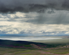
Namtso is renowned as one of the most beautiful places in the Nyainqêntanglha mountain range. Its cave hermitages have for centuries been the destination of Tibetan pilgrims. A surfaced road across Laken Pass at 5186 m was completed to the lake in 2005, enabling easy access from Lhasa and the development of tourism at the lake. Settlements in the area include Dobjoi, Donggar and Cha'gyungoinba. The Tashi Dor monastery is located at the southeastern corner of the lake.
Around the area's natural elements, historical and anthropological background, a 2010 romantic drama Chinese: 香格里拉 Shangri-La, starring China's popular actor Hu Ge, was broadcast at CCTV1 and received positive reviews.[4] Some scenes in the 2002 Hong Kong film The Touch were filmed at the lake. Namtso Lake was featured in Episode 4, The Roof of the World, of BBC TV series: Himalaya with Michael Palin.
Gallery
|


Asteroid
Asteroid 248388 Namtso, discovered by Italian astronomer Vincenzo Casulli in 2005, was named after the lake.[5] The official naming citation was published by the Minor Planet Center on 5 October 2017 (M.P.C. 106504).[6]
See also
- Gomang Co
- Kanas Lake
- Lake Urru
- Laken Pass (Lakenla)
- Siling Lake
References
- Schütt, Brigitta; Berking, Jonas; Frechen, Manfred; Yi, Chaolu (September 2008). Late Pleistocene Lake Level Fluctuations of the Nam Co, Tibetan Plateau, China (PDF). Zeitschrift für Geomorphologie. Vol. 52. pp. 57–74. Bibcode:2008ZGmS...52...57S. doi:10.1127/0372-8854/2008/0052S2-0057.
- "Chinese, German scientists record new depth of Nam Co Lake". Archived from the original on December 3, 2010.
- "Namtso Lake". Universities Space Research Association. October 5, 2004.
- "胡歌主演《香格里拉》30分钟片花 - 电视剧《香格里拉》_新浪视频" [Hu Ge starring in "Shangri-La" 30 minutes- TV series "Shangri-La"_Sina video]. SINA Corporation.
- "248388 Namtso (2005 SE19)". Minor Planet Center. Retrieved July 21, 2019.
- "MPC/MPO/MPS Archive". Minor Planet Center. Retrieved July 21, 2019.
External links
| County-level divisions |
|   | ||||
|---|---|---|---|---|---|---|
| Towns and villages |
| |||||
| Monasteries and palaces |
| |||||
| Other landmarks |
| |||||
| Transport |
| |||||
| Government |
| |||||
На других языках
[de] Nam Co
Der Nam Co (auch Namtsho oder Namtso; tibetisch གནམ་མཚོ་ Wylie .mw-parser-output .Latn{font-family:"Akzidenz Grotesk","Arial","Avant Garde Gothic","Calibri","Futura","Geneva","Gill Sans","Helvetica","Lucida Grande","Lucida Sans Unicode","Lucida Grande","Stone Sans","Tahoma","Trebuchet","Univers","Verdana"}gnam mtsho, chinesisch 納木錯 / 纳木错, Pinyin Nàmù Cuò; mongolisch Tengrinor „Himmelssee“) ist ein Salzsee im Autonomen Gebiet Tibet der Volksrepublik China.- [en] Namtso
[fr] Lac Namtso
Le lac Namtso (tibétain : གནམ་མཚོ་, Wylie : gnam mtsho, pinyin tibétain : Nam Co, THL : Namtso, translittération en chinois : 纳木错 ; pinyin : nàmù cuò Nam Co est son nom officiel international en Chine), également appelé en mongol Tangri Nagur ou Tenger nuur (mongol classique et Mongol de Chine : ᠲᠩᠷᠢ ᠨᠠᠭᠤᠷ (Tangri naɣur), khalkha : Тэнгэр нуур (Tenger nuur) littéralement lac céleste), est l'un des lacs les plus célèbres du Tibet.[it] Lago Namtso
Il Lago Namtso, situato a 4.730 metri, è il secondo lago più grande d'acqua salata in Cina, e il lago salato più alto al mondo.[ru] Нам-Цо
Нам-Цо[2][4][5][6] (На́мцо[1][7][6][8], Тэ́нгри-Нур[2][4][5][6] — «небесное озеро»[3]; кит. 納木湖[4], Nàmù Cuò; тиб. གནམ་མཚོ, Вайли gnam mtsho་[источник не указан 252 дня]) — бессточное солёное озеро[6] на юго-западе Китая в Тибетском автономном районе[2] на границе уездов Дамшунг (в составе городского округа Лхаса) и уезда Бэнгён (в округе Нагчу)[3], примерно в 110 км к северо-западу от Лхасы[9].Другой контент может иметь иную лицензию. Перед использованием материалов сайта WikiSort.org внимательно изучите правила лицензирования конкретных элементов наполнения сайта.
WikiSort.org - проект по пересортировке и дополнению контента Википедии