geo.wikisort.org - Reservoir
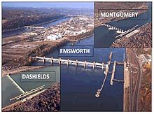
Montgomery Locks and Dam is a lock and dam on the Ohio River, located 32 miles downstream of Pittsburgh. There are two locks, one for commercial barge traffic that's 600 feet long by 110 feet wide, and the recreational auxiliary lock is 360 feet long by 56 feet wide. Montgomery locks averages about 300 commercial lock throughs every month and 150 lock throughs a month on the recreational auxiliary lock. The average cost to keep the lock and dam operationally ready averaged $5.8 million per year from the years 2010-2014.[1][2]
| Montgomery Locks and Dam | |
|---|---|
 | |
| Official name | Montgomery Locks and Dam |
| Coordinates | 40.6503°N 80.3860°W |
| Construction began | 1932 |
| Opening date | June 1936 |
| Operator(s) | |
| Dam and spillways | |
| Type of dam | Gated |
| Impounds | Ohio River |
| Length | 1,379 feet |
| Reservoir | |
| Normal elevation | 682 feet above sealevel |
See also
References
External links
- U.S. Army Corps of Engineers, Pittsburgh District
- U.S. Army Corps of Engineers, Huntington District
- U.S. Army Corps of Engineers, Louisville District
Текст в блоке "Читать" взят с сайта "Википедия" и доступен по лицензии Creative Commons Attribution-ShareAlike; в отдельных случаях могут действовать дополнительные условия.
Другой контент может иметь иную лицензию. Перед использованием материалов сайта WikiSort.org внимательно изучите правила лицензирования конкретных элементов наполнения сайта.
Другой контент может иметь иную лицензию. Перед использованием материалов сайта WikiSort.org внимательно изучите правила лицензирования конкретных элементов наполнения сайта.
2019-2026
WikiSort.org - проект по пересортировке и дополнению контента Википедии
WikiSort.org - проект по пересортировке и дополнению контента Википедии