geo.wikisort.org - Reservoir
Lop Nur or Lop Nor (from a Mongolian name meaning "Lop Lake", where "Lop" is a toponym of unknown origin[1]) is a former salt lake, now largely dried up, located in the eastern fringe of the Tarim Basin, between the Taklamakan and Kumtag deserts in the southeastern portion of the Xinjiang (Xinjiang Uygur Autonomous Region). Administratively, the lake is in Lop Nur town (Chinese: 罗布泊镇; pinyin: Luóbùpō zhèn), also known as Luozhong (罗中; Luózhōng) of Ruoqiang County, which in its turn is part of the Bayingolin Mongol Autonomous Prefecture.
| Lop Nur | |||||||||||
|---|---|---|---|---|---|---|---|---|---|---|---|
 Satellite picture of the Basin of the former sea of Lop Nur; the concentric shorelines of the vanished lake are visible. | |||||||||||
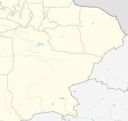 Lop Nur Location of Lop Nur within Xinjiang | |||||||||||
| Chinese name | |||||||||||
| Traditional Chinese | 羅布泊 | ||||||||||
| Simplified Chinese | 罗布泊 | ||||||||||
| |||||||||||
| Alternative Chinese name | |||||||||||
| Traditional Chinese | 羅布淖爾 | ||||||||||
| Simplified Chinese | 罗布淖尔 | ||||||||||
| |||||||||||
| Mongolian name | |||||||||||
| Mongolian Cyrillic | ᠯᠣᠪ ᠨᠠᠭᠤᠷ Лоб Нуур | ||||||||||
| Uyghur name | |||||||||||
| Uyghur | لوپنۇر | ||||||||||
| |||||||||||
The lake system into which the Tarim River and Shule River empty is the last remnant of the historical post-glacial Tarim Lake, which once covered more than 10,000 square kilometres (3,900 sq mi) in the Tarim Basin. Lop Nur is hydrologically endorheic – it is landbound and there is no outlet. The lake measured 3,100 square kilometres (1,200 sq mi) in 1928, but has dried up due to construction of dams which blocked the flow of water feeding into the lake system, and only small seasonal lakes and marshes may form. The dried-up Lop Nur Basin is covered with a salt crust ranging from 30 to 100 centimetres (12 to 39 in) in thickness.
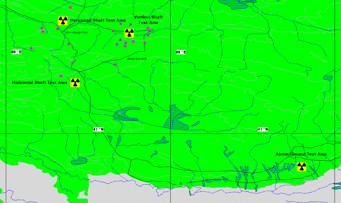
An area to the north west of Lop Nur has been used as a nuclear testing site,[2] and since the discovery of potash at the site in the mid-1990s, it is also the location of a large-scale mining operation.[3] There are some restricted areas under military management and cultural relics protection points in the region, which are not open to the public.[4]
History

From around 1800 BC until the 9th century the lake supported a thriving Tocharian culture. Archaeologists have discovered the buried remains of settlements, as well as several of the Tarim mummies, along its ancient shoreline. Former water resources of the Tarim River and Lop Nur nurtured the kingdom of Loulan since the second century BC, an ancient civilisation along the Silk Road, which skirted the lake-filled basin. Loulan became a client state of the Chinese empire in 55 BC, renamed Shanshan. Faxian went by the Lop Desert on his way to the Indus valley (395–414),[5] followed by later Chinese pilgrims. Marco Polo in his travels passed through the Lop Desert.[6] In the 19th century and early 20th century, the explorers Ferdinand von Richthofen, Nikolai Przhevalsky, Sven Hedin and Aurel Stein visited and studied the area.[7] It is also likely that Swedish soldier Johan Gustaf Renat had visited the area when he was helping the Zunghars to produce maps over the area in the eighteenth century.[8]
The lake was given various names in ancient Chinese texts.[9] In Shiji it was called Yan Ze (鹽澤, literally Salt Marsh), indicating its saline nature, near which was located the ancient Loulan Kingdom.[10] In Hanshu it was called Puchang Hai (蒲昌海, literally Sea of Abundant Reed) and was given a dimension of 300 to 400 li (roughly 120–160 km) in length and breadth,[11] indicating it was once a lake of great size. These early texts also mentioned the belief, mistaken as it turns out, that the lake joins the Yellow River at Jishi through an underground channel as the source of the river.[11][12]
The lake was referred to as the "Wandering Lake" in the early 20th century due to the Tarim River changing its course, causing its terminal lake to alter its location between the Lop Nur dried basin, the Kara-Koshun dried basin and the Taitema Lake basin.[13] This shift of the terminal lake caused some confusion amongst the early explorers as to the exact location of Lop Nur. Imperial maps from the Qing dynasty showed Lop Nur to be located in similar position to the present Lop Nur dried basin, but the Russian geographer Nikolay Przhevalsky instead found the terminal lake at Kara-Koshun in 1867. Sven Hedin visited the area in 1900–1901 and suggested that the Tarim river periodically changed its course to and from between its southbound and northbound direction, resulting in a shift in the position of the terminal lake. The change in the course of the river, which resulted in Lop Nur drying up, was also suggested by Hedin as the reason why ancient settlements such as Loulan had perished.[14]
In 1921, due to human intervention, the terminal lake shifted its position back to Lop Nur. The lake measured 2400 km2 in area in 1930–1931. In 1934, Sven Hedin[15] went down the new Kuruk Darya ("Dry River") in a canoe. He found the delta to be a maze of channels and the new lake so shallow that it was difficult to navigate even in a canoe. He had previously walked the dry Kuruk Darya in a caravan in 1900.
In 1952 the terminal lake then shifted to Taitema Lake when the Tarim River and Konque River were separated through human intervention, and Lop Nur dried out again by 1964. In 1972, the Great West Sea Reservoir (Daxihaizi, 大西海子) was built at Tikanlik, water supply to the lake was cut off, and all the lakes for the most part then dried out, with only small seasonal lakes forming in local depressions in Taitema.[13] The loss of water to the lower Tarim River Valley also led to the deterioration and loss of poplar forests and tamarix shrubs that used to be extensively distributed along the lower Tarim River Valley forming the so-called "Green Corridor". In 2000, in an effort to prevent further deterioration of the ecosystem, water was diverted from Lake Bosten in an attempt to fill the Taitema Lake.[16] The Taitema Lake however had shifted 30 to 40 kilometres (19 to 25 mi) westwards during the past 40 years due in part to the spread of the desert.[17] Another cause of the destabilization of the desert has been the cutting of poplars and willows for firewood; in response, a restoration project to reclaim the poplar forests was initiated.[18][19]
The Kara-Koshun dried basin may be considered part of the greater Lop Nur.[13]
On 17 June 1980, Chinese scientist Peng Jiamu disappeared while walking into Lop Nur in search of water. His body was never found, and his disappearance remains a mystery. On 3 June 1996, the Chinese explorer Yu Chunshun died while trying to walk across Lop Nur.[20]
Nuclear weapons test base

China established the Lop Nur Nuclear Test Base on 16 October 1959 with Soviet assistance in selection of the site, with its headquarters at Malan (马兰, Mǎlán), about 125 kilometres (78 mi) northwest of Qinggir.[2] The first Chinese nuclear bomb test, codenamed "Project 596", occurred at Lop Nur on 16 October 1964. China detonated its first hydrogen bomb on 17 June 1967. Until 1996, 45 nuclear tests were conducted. These nuclear tests were conducted by dropping bombs from aircraft and towers, launching missiles, detonating weapons underground and in the atmosphere.[21]
In 2009, Jun Takada, a Japanese scientist known for prominently opposing the tests as "the Devil's conduct", published the results of his computer simulation which suggests – based on deaths from Soviet tests – that 190,000 people could have died in China from nuclear-related illnesses.[22] Enver Tohti, an exiled pro-Uyghur independence activist, claimed that cancer rates in the province of Xinjiang were 30 to 35% higher than the national average.[23] On 29 July 1996, China conducted its 45th and final nuclear test at Lop Nor, and issued a formal moratorium on nuclear testing the following day, although further subcritical tests were suspected.[24] In 2012, China announced plans to spend US$1 million to clean up the Malan nuclear base in Lop Nor to create a red tourism site.[25]
Lop Nur is home to the wild Bactrian camel, which is a separate species from the Bactrian camel. The camels have continued to breed naturally despite the nuclear testing. China signed the Comprehensive Nuclear-Test-Ban Treaty in 1996 but did not ratify it.[26] Subsequently, the camels were classified as an endangered species on the IUCN Red List.[27] Since the cessation of nuclear testing at Lop Nur, human incursions into the area have caused a decline in the camel population.[27][28][29] Wild Bactrian camels have been classified as critically endangered since 2002[27] and approximately half of the 1400 remaining wild Bactrian camels live on the former Lop Nur test base, which has been designated the Lop Nur Wild Camel National Nature Reserve.
Transportation
A highway from Hami to Lop Nur (Xinjiang Provincial Highway 235) was completed in 2006.[30]
The Hami–Lop Nur Railway, which runs 374.83 kilometres (232.91 mi) north to Hami, along the same route, opened to freight operations in November 2012. The railway is used to transport potassium-rich salt mined at the lake to the Lanzhou–Xinjiang railway.[30]
Archaeological sites
Given the extreme dryness and resulting thin population, remains of some buildings survived for a significant period of time. When ancient graves, some a few thousand years old, were opened the bodies were often found to be mummified and grave goods well preserved. The earliest sites are associated with an ancient people of Indo-European origin.
Loulan
Loulan or Kroran was an ancient kingdom based around an important oasis city already known in the 2nd century BCE on the north-eastern edge of the Lop Desert.[citation needed] It was renamed Shanshan after Chinese took control of the kingdom in 1st century BCE. It was abandoned some time in the seventh century. Its location was discovered by Sven Hedin in 1899, who excavated some houses and found a wooden Kharosthi tablet and many Chinese manuscripts from the Jin dynasty (266–420).[14] Aurel Stein also excavated at the site in the beginning of the 20th century, while Chinese archaeologists explored the area in the latter part of the 20th century. A mummy called the "Beauty of Loulan" was found at a cemetery site on the bank of Töwän River.
Xiaohe Cemetery
The Xiaohe Cemetery is located to the west of Lop Nur. This Bronze Age burial site is an oblong sand dune, from which more than thirty well preserved mummies have been excavated. The entire Xiaohe Cemetery contains about 330 tombs, about 160 of which have been violated by grave robbers.[31]
A local hunter guided the Swedish explorer and archeologist Folke Bergman to the site in 1934. An excavation project by the Xinjiang Cultural Relics and Archaeology Institute began in October 2003. A total of 167 tombs have been dug up since the end of 2002 and excavations have revealed hundreds of smaller tombs built in layers, as well as other precious artifacts. In 2006, a valuable archeological finding was uncovered: a boat-shaped coffin wrapped in ox hide, containing the mummified body of a young woman.[32]
Qäwrighul
In 1979, some of the earliest of the Tarim mummies were discovered in burial sites at Qäwrighul (Gumugou), which is located to the west of Lop Nur, on the Könchi (Kongque) river. Forty-two graves, most of which dated from 2100 to 1500 BC, were found. There were two types of tomb at the site, belonging to two different time periods. The first type of burial featured shaft pit graves, some of which had poles at either end to mark east and west. Bodies were found extended, usually facing east, and sometimes were wrapped in wool weavings and wearing felt hats. Artifacts found included basketry, wheat grains, cattle and sheep/goat horns, bird bone necklaces and bracelets, nephrite beads, and fragments of copper (or bronze), although no pottery was discovered.
The second type of burial, from a later period, also consisted of shaft pit graves, surrounded by seven concentric circles of poles. Six male graves were found, in which the bodies were extended on their backs, and facing towards the east. Few artifacts were found, except for some traces of copper, or bronze.[33]
Miran
Miran is located to the south-west of Lop Nur. Buddhist monasteries were excavated here, and murals and sculptures showed artistic influences from India and Central Asia, with some showing influences from as far as Rome.
See also
- Lop Desert
- Tarim Basin
- Tarim mummies
- Silk Road transmission of Buddhism
- Aral Sea
- Ruoqiang Town
- Charklik
- List of nuclear weapons tests of China
References
- Barber, Elizabeth (2000). The Mummies of Urümchi. W. W. Norton & Company. p. 125.
Two groups have laid claim to nor, the second half of Lop Nor. Nor is Mongol for 'lake' and occurs as part of many lake names in Xinjiang and other parts of Central Asia, while nur is Uyghur for 'bright' (as in the white of the salt flats). Mongol probably wins this one. But lop is opaque in both languages and in Chinese too, a fact suggesting that the name goes back to a time before Turks, Mongols, or Chinese had entered the territory.
- "Lop Nor Nuclear Weapons Test Base". nti. Retrieved 3 August 2007.
- "Lop Nur, Xinjiang, China". Earth Observatory. 19 June 2011.
 This article incorporates text from this source, which is in the public domain.
 - 三问哈罗铁路. Sina Weibo. 《新疆哈密广播电视报》. 6 December 2012.
- Fa-hsien; Legge, James (1886). A record of Buddhistic kingdoms; being an account by the Chinese monk Fâ-Hien of his travels in India and Ceylon, A.D. 399-414, in search of the Buddhist books of discipline. Translated and annotated with a Corean recension of the Chinese text. Robarts – University of Toronto. Oxford Clarendon Press.
- Dent, J. M. (1908), "Chapter 36: Of the Town of Lop Of the Desert in its Vicinity – And of the strange Noises heard by those who pass over the latter", The travels of Marco Polo the Venetian, pp. 99–101
- "The Wandering Lake". NASA. Archived from the original on 16 April 2002. Retrieved 3 August 2007. This article incorporates text from this source, which is in the public domain.
- Strindberg, August. "En svensk karta över Lop-nor och Tarimbäckenet" (in Swedish). Archived from the original on 28 September 2007. Retrieved 16 August 2007.
- Zizhi Tongjian Original text: 蒲昌海,一名泑澤,亦名鹽澤,亦名輔日海,亦名穿蘭,亦名臨海,在沙州西南。Translation; Puchang Hai, another name is You Ze, also called Yan ze, Furi Hai, Chuan Lan, and Lin Hai. It is located to the south-west of Shazhou (Dunhuang).
- Shiji Original text: 而樓蘭、姑師邑有城郭,臨鹽澤。Translation: The cities of Loulan and Gushi have walls; they lie near to Yan Ze.
- Hanshu Original text: 蒲昌海,一名鹽澤者也,去玉門、陽關三百餘里,廣袤三四百里。其水亭居,冬夏不增減,皆以為潛行地下,南出於積石,為中國河雲. Translation: Puchang Hai, also named Yan Ze, lies over 300 li from the Yumen and Yangguan Pass, and is 300 to 400 li in length and breadth. Its waters are stagnant, and do not increase or decrease during the winter or summer. It is generally believed that the water flows hidden underground, emerges south at Jishi, and becomes the Chinese River (meaning Yellow River).
- Lou Yulie, ed. (17 September 2015). Buddhism. Brill. p. 270. ISBN 9789047427971.
- Zhao Songqiao and Xia Xuncheng (1984). "Evolution of the Lop Desert and the Lop Nor". The Geographical Journal. 150 (3): 311–321. doi:10.2307/634326. JSTOR 634326.
- Makiko Onishi and Asanobu Kitamoto. "Hedin, the Man Who Solved the Mystery of the Wandering Lake: Lop Nor and Lou-lan". Digital Silk Road.
- Sven Hedin, The Wandering lake, 1940. The river was also called the Kum Darya (Sand River). The Gizi map of Xinjiang calls it the Konche, which is probably a mistake.
- Liang Chao (13 April 2004). "Quenching thirst in Tarim Basin". China Daily. Archived from the original on 10 May 2012.
- "Desert Intrudes upon Tarim Lake". china.org.cn. Retrieved 3 August 2007.
- "Tarim River Ecological Protection Suggested". china.org.cn. Retrieved 3 August 2007.
- "China Creates 'Man-made Oasis' Along Longest Inland River". China DevelopmentGateway. Xinhua News Agency. 15 September 2007.
- "Found Dead – Yu Chunshun, 48, Intrepid Chinese explorer". asiaweek.com. Retrieved 18 September 2007.
- Burrows, Andrew S.; Fieldhouse, Richard (1993). Nuclear Weapons Databook. Boulder: Westview Press. p. 380.
- Subhabrata Das (20 April 2009). "China's nuclear tests allegedly caused 190000 deaths". Digital Journal.
- Zeeya Merali (8 July 2009). "Did China's Nuclear Tests Kill Thousands and Doom Future Generations?". Scientific American. Retrieved 27 October 2012.
- Jeffrey Lewis (3 April 2009). "Subcritical Testing at Lop Nor". Arms Control Wonk. Archived from the original on 31 October 2012. Retrieved 31 October 2012.
- "China to open ex-atomic site to tourists". Beijing: United Press International. 17 October 2012. Retrieved 27 October 2012.
- Borger, Julian (16 April 2020). "China may have conducted low-level nuclear test, US report claims". The Guardian. ISSN 0261-3077. Retrieved 23 April 2020.
- Hare, J. (2008). "Camelus ferus". IUCN Red List of Threatened Species. 2008. doi:10.2305/iucn.uk.2008.rlts.t63543a12689285.en.
- "'New' camel lives on salty water". BBC News. 6 February 2001.
- "Wild Camel". Wild Camel Protection Foundation.
- China starts building railway into "sea of death" Archived 2012-02-29 at the Wayback Machine, gov.cn, Thursday, 4 March 2010
- "Burial Site from the Bronze Age, Lop Nur, Xinjiang". www.china.org.cn. Retrieved 18 September 2007.
- "Silk Road Documentary Unearths Latest Findings". china.org.cn. Retrieved 18 September 2007.
- Kwang-tzuu Chen and Fredrik T. Hiebert (1995). "The Late Prehistory of Xinjiang in Relation to Its Neighbors". Journal of World Prehistory 9 (2): 243–300.
External links
- Map of the Lop Nur nuclear test facility
- Lop Nor Nuclear Weapons Test Base
- DF-31 Tested on 10 June 1994
- Lop Desert
- Surveying the Lop Nor
- Salt Fields in Former “Wandering” Lake Lop Nur, China - May 13th, 2009 - Earth Snapshot
- Downloadable article: "Evidence that a West-East admixed population lived in the Tarim Basin as early as the early Bronze Age" Li et al. BMC Biology 2010, 8:15.
На других языках
[de] Lop Nor
Der ausgetrocknete Salzsee Lop Nor (chinesisch .mw-parser-output .Hans{font-size:110%}罗布泊, Pinyin luó bù pō oder nach 1971 chinesisch 大耳朵, Pinyin Da'erduo für „Große Ohrmuschel“) liegt in einer Höhe von 780 m an der tiefsten Stelle des Tarimbeckens im nordwestchinesischen Uigurischen Autonomen Gebiet Xinjiang. Er war einer der größten und am weitesten vom Meer entfernten abflusslosen Salzseen der Erde. Nach vorübergehender Austrocknung seines Zuflusses Kum-darja füllte er sich im Jahr 1921 wieder, bis er von 1958 bis 1961[2] oder bis 1962[3] zum letzten Mal austrocknete. Unter der braunen Erdkruste und der steinharten, aber dünnen weißen Salzkruste, die das Becken des ausgetrockneten Sees überziehen, dehnt sich ein Salzsumpf aus[4].- [en] Lop Nur
[es] Lop Nor
El Lop Nor (uigur: لوپنۇر; en chino tradicional, 羅布泊; en chino simplificado, 罗布泊; pinyin, Luóbù Pō), llamado también lago Lop (llamado en mongol y uigur Lop Nuur o Lop Nur, en chino tradicional, 羅布淖爾; en chino simplificado, 罗布淖尔; pinyin, Luóbù Naoer) (también transcrito como Lob-nor, Lo-pu po o lago Taitema; y en los Anales Han: P'u-ch'ang Hai, Lou-lan Hai o Yen-tse) es un grupo de pequeños, y hoy en día estacionales, lagos salados y marjales localizados entre el desierto de Taklamakán y el desierto de Gobi, al sur de las montañas Kuruktag, en la esquina suroriental de la Región Autónoma Uigur de Sinkiang, al noroeste de la República Popular China (centrados alrededor de las coordenadas 40.4, 90.8). Históricamente, era un gran lago (en 1928 tenía 3.100 km²) que hoy está totalmente seco dado que el caudal de los ríos que lo alimentaban ha sido empleado para usos humanos y agrícolas. Hoy día la región forma parte del desierto de Lop.[fr] Lob Nor
Le Lob Nor (du mongol, mongol cyrillique : Лоп Нуур translit. Lop Nuur, littéralement, lac Lop, en ouïghour : لوپنۇر), débouché du fleuve Tarim à l'est du désert du Taklamakan, est un immense marécage salé dont la superficie diminue au fil des siècles. Il est situé au sud de Tourfan et au nord de l'ancienne ville de Miran, dans la préfecture autonome mongole de Bayin'gholin de la région autonome chinoise du Xinjiang. Les anglophones l'appellent Lop Nur et l'on rencontre aussi le nom de Lop Nor en français.[it] Lop Nur
Il Lop Nur (羅布泊T, 罗布泊S, LuóbùbóP, Lo-pu P'oW), noto anche come Lop Nor, era un lago salato della Cina nord-occidentale che attualmente si presenta come un letto lacustre incrostato di sale. È situato nel bacino del Tarim, nella parte orientale del deserto del Takla Makan, nella Regione Autonoma Uigura dello Xinjiang, ed è una delle aree più desolate della Cina.[ru] Лобнор
Лобно́р[1][2][3] (Лоб-нор[4], уйг. لوپنۇر, кит. 罗布泊, название монгольского происхождения, уйгурское название — Каракошуккол) — высохшее бессточное озеро на западе Китая, в юго-восточной части Кашгарской (Таримской) равнины, на территории Синьцзян-Уйгурского автономного района (СУАР), на высоте около 780 метров выше уровня моря.Другой контент может иметь иную лицензию. Перед использованием материалов сайта WikiSort.org внимательно изучите правила лицензирования конкретных элементов наполнения сайта.
WikiSort.org - проект по пересортировке и дополнению контента Википедии