geo.wikisort.org - Reservoir
The IJ (Dutch: [ɛi̯] (![]() listen); sometimes shown on old maps as Y or Ye) is a body of water, formerly a bay, in the Dutch province of North Holland. It is known for being Amsterdam's waterfront.
listen); sometimes shown on old maps as Y or Ye) is a body of water, formerly a bay, in the Dutch province of North Holland. It is known for being Amsterdam's waterfront.
| IJ | |
|---|---|
 The IJ in 2017 | |
 IJ | |
| Location | Amsterdam, Netherlands |
| Coordinates | 52°22′51″N 4°56′38″E |
Etymology
The name IJ is derived from the West Frisian word ie, alternatively spelled ije, meaning water and cognate with the English word ea.[1] The name consists of the digraph ij which is capitalized as IJ.
Geography

Today, the IJ is divided into two parts:
- To the west of the Oranjesluizen (Oranje Locks), the Binnen-IJ (inner IJ), or Afgesloten-IJ (closed IJ), is directly connected to the North Sea Canal, where the port of IJmuiden and the North Sea can be reached.
- To the east of the Oranjesluizen, the Buiten-IJ (outer IJ) is an extension of the IJmeer which is itself an extension of the Markermeer.
The IJ is connected to the North Sea to the west and the IJmeer to the east by a set of locks.
History
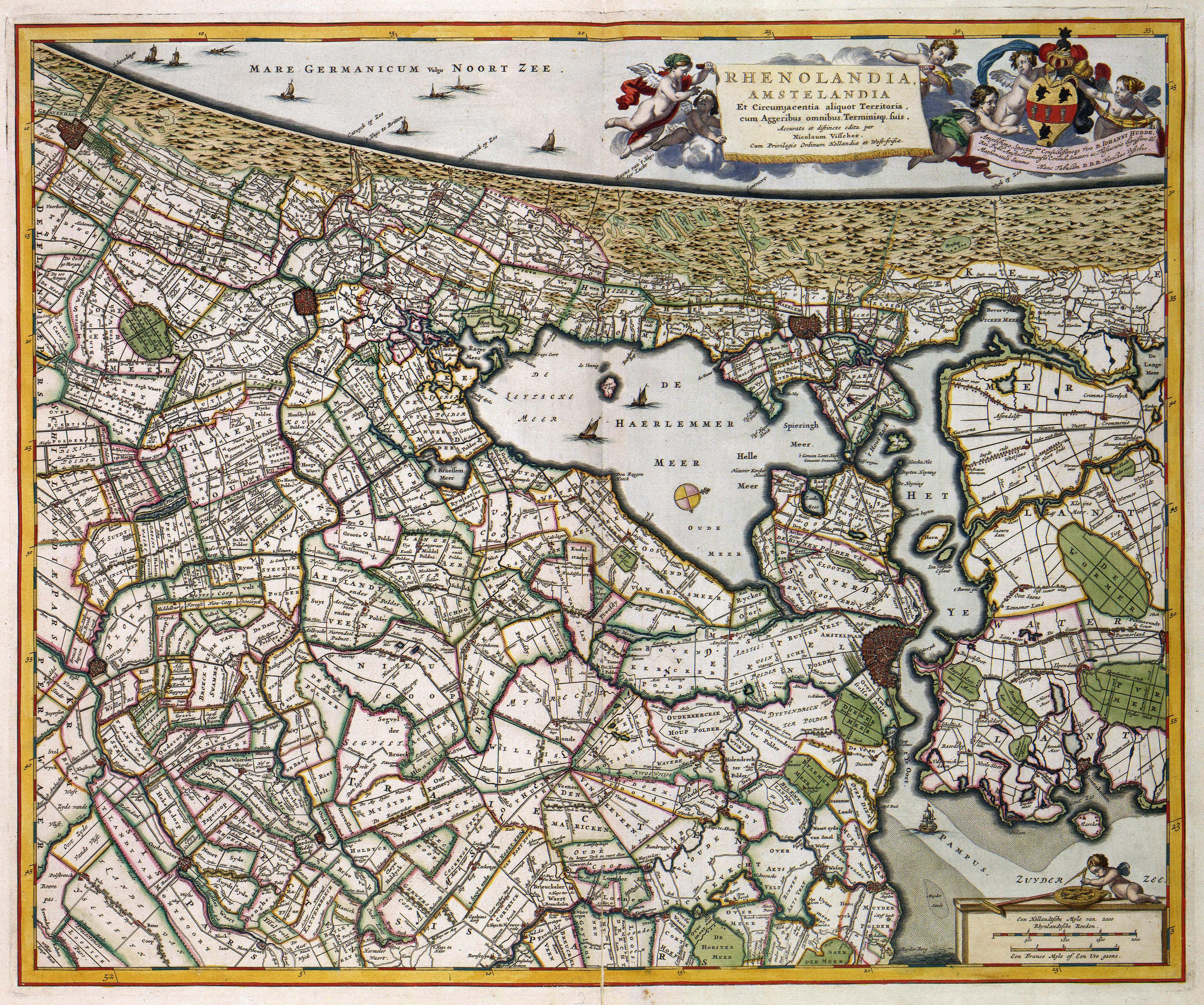


There are several theories about the origins of the IJ. Perhaps it began as a stream, following a breakthrough in the dunes of Castricum. More likely, the IJ is a remnant of a northern arm of the Rhine delta. Finally, the IJ could also come from the lake Almere or Flevo. During the Roman period the IJ connected on one side with lake Flevo and the Vecht (Utrecht) and the other with the North Sea. Connection with the North Sea has subsequently disappeared, while the IJ in the Middle Ages has expanded. This is due to the emergence of the Zuiderzee, itself a bay of the North Sea resulting from a number of storms.
At the end of the Middle Ages, the IJ was a long and narrow brackish bay that connected to the Zuiderzee and stretched from Amsterdam in the east to Velsen in the west. At its west end, only the natural dune ridge across the Dutch North Sea coast prevented the IJ, which grew ever larger through the centuries, from directly connecting to the North Sea and so making the North Holland peninsula nearly an island. By the seventeenth century, however, access to the IJ became difficult due to sand bars across its mouth, and ships becoming bigger, and it was nearly impossible for seafaring vessels to reach the city of Amsterdam. At the same time, the bay gnawed away at the surrounding farmlands, almost connecting with the Haarlemmermeer (Lake Haarlem) and seriously threatening the cities of Haarlem and Amsterdam.
Plans were put forth to reclaim both the Haarlemmermeer and the IJ and turn them into polders. The Haarlemmermeer was first, falling dry in 1852, and the largest part of the IJ followed suit between 1865 and 1876, with only a small lake remaining at Amsterdam that was closed off from the Zuiderzee by the Oranje locks. At the same time, the North Sea Canal was constructed in the former IJ basin to provide Amsterdam with access to the sea again and revive its ailing port. It cut through the isthmus to connect to the North Sea near the town of Velsen; a new port, IJmuiden ("IJ's mouth") was built at its west end. The east end of the IJ polders near Amsterdam was given over to industry, and a large new seaport area was constructed.
The Buiten-IJ hosted the mixed dinghy sailing events for the 1928 Summer Olympics in neighboring Amsterdam.[2][3] It also hosted two events for the 1920 Summer Olympics in Antwerp.[4]
The nautical event SAIL Amsterdam takes place on and around the IJ.
References
- M. Philippa, F. Debrabandere, A. Quak, T. Schoonheim & N. van der Sijs, "A - (stromend water, riviertje)" (in Dutch), Etymologisch Woordenboek van het Nederlands, 2003–2009. Retrieved on 17 October 2020.
- 1928 Summer Olympics official report, featuring map of the Buiten IJ. pp. 271–2, 274.
- "Sailing at the 1928 Amsterdam Summer Games: Mixed One Person Dinghy | Olympics at Sports-Reference.com". web.archive.org. 2015-04-02. Retrieved 2021-10-02.
- "Sailing at the 1920 Antwerpen Summer Games: Mixed 12 foot | Olympics at Sports-Reference.com". web.archive.org. 2012-11-03. Retrieved 2021-10-02.
External links
 Media related to IJ at Wikimedia Commons
|
|
Olympic venues in sailing | ||
|---|---|---|
| 20th century |
|  |
| 21st century |
| |
На других языках
[de] IJ (Amsterdam)
Das IJ (niederländisch Het IJ – ausgesprochen [.mw-parser-output .IPA a{text-decoration:none}ɛɪ]) war ursprünglich ein tief nach Westen in die Provinz Nordholland reichender Meeresarm der Zuiderzee, an dem der historische Hafen der niederländischen Hauptstadt lag. Durch die Verbindung der Zuiderzee mit der Nordsee war das IJ und damit auch der Hafen von Amsterdam durch die Gezeiten beeinflusst, deren Tidenhub ca. 30 cm betrug. Mit dem Bau des Nordseekanals wurde das IJ bis zur geplanten Kanaltrasse eingepoldert und am östlichen Ende durch den IJ-Damm von der Zuiderzee abgetrennt. Die Wasserstraßen beidseits des Damms werden seitdem als Binnen-IJ und Außen-IJ (Buiten-IJ) bezeichnet.- [en] IJ (Amsterdam)
[es] IJ (Ámsterdam)
El IJ (pronunciado [ɛi̯]) (a veces aparece en los mapas antiguos como "Y" o "Ye") es un cuerpo de agua, que antiguamente fue una bahía, en la provincia neerlandesa de Holanda Septentrional.[1] Es conocido por ser costa de Ámsterdam. El nombre deriva del término genérico germánica para "agua" y es similar a otros Aa / Ee nombres de las masas de agua. En neerlandés, el nombre está formado por el dígrafo ij, que se considera una sola letra, y por lo tanto, se representa con letras mayúsculas.[fr] IJ (Amsterdam)
L'IJ (en néerlandais : [ɛi̯] .mw-parser-output .prononciation>a{background:url("//upload.wikimedia.org/wikipedia/commons/thumb/8/8a/Loudspeaker.svg/11px-Loudspeaker.svg.png")center left no-repeat;padding-left:15px;font-size:smaller}Écouter) est un lac néerlandais d'eau douce, ancien bras du Zuiderzee, situé à Amsterdam, en Hollande-Septentrionale. Il permet de joindre l'IJmeer au sud-est au canal de la Mer du Nord au nord-ouest. Séparé en deux par les écluses d'Orange entre Schellingwoude et le Zeeburgereiland, il est le reliquat d'une baie beaucoup plus vaste.[ru] Эй
Эй (нидерл. IJ [ɛi̯], на старых картах иногда показана как «Y» или «Ye») — бывшая бухта в нидерландской провинции Северная Голландия. Известна как одна из главных водных артерий Амстердама. Название происходит от германского слова, значащего «вода». В нидерландском языке название состоит из диграфа IJ, являющегося единой буквой, что делает оба символа в названии заглавными.Другой контент может иметь иную лицензию. Перед использованием материалов сайта WikiSort.org внимательно изучите правила лицензирования конкретных элементов наполнения сайта.
WikiSort.org - проект по пересортировке и дополнению контента Википедии