geo.wikisort.org - River
The North Sea Canal (Dutch: Noordzeekanaal) is a Dutch ship canal from Amsterdam to the North Sea at IJmuiden, constructed between 1865 and 1876 to enable seafaring vessels to reach the port of Amsterdam.[1] This man-made channel terminates at Amsterdam in the closed-off IJ Bay, which in turn connects to the Amsterdam-Rhine Canal.
| North Sea Canal | |
|---|---|
 | |
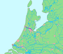 Location of canal in dark blue. | |
| Native name | Noordzeekanaal (Dutch) |
| Location | |
| Country | Netherlands |
| Province | North Holland |
| Physical characteristics | |
| Source | IJ |
| • location | Amsterdam |
| • coordinates | 52°23′45″N 4°53′30″E |
| Mouth | North Sea |
• location | IJmuiden |
• coordinates | 52°27′50″N 4°33′30″E |
• elevation | 0 m (0 ft) |
| Length | 25 km (16 mi) |
The drainage of the canal to the North Sea is done through the Spui Locks at IJmuiden, augmented by the largest pumping station in Europe. This system is vital to the groundwater management of the Western Netherlands.
History
To improve the connection between the harbour of Amsterdam and the North Sea, the North Holland Canal was built in 1824. But this long and narrow canal was quickly inadequate to handle the growing boat traffic. A few decades later it was decided to dig a new canal at the narrowest point in Holland and thereby providing the shortest route to the sea.
Digging began on 8 March 1865, at the dunes of Breesaap and lasted until 1876. Since no Dutch company was willing to take on this task, the project was awarded to an English contractor.[citation needed]
The North Sea Canal was built by digging a channel through the old IJ Bay and lining it with dikes, after which the remaining portions of the IJ Bay were reclaimed and turned into polders. From this bay to the sea, a new canal was dug through the dunes at Velsen. To accommodate drainage of and shipping on the tributaries of the IJ, such as the Spaarne, the Zaan, and the Nauerna Canal, nine auxiliary canals needed to be dug as well (Side Canals "A" to "I").
A small set of locks (Zuidersluis) were built at the mouth in 1876 where the new town of IJmuiden (Dutch for "IJ Mouth") formed. In 1896 the Middle Locks (Middensluis) were built, followed by the North Locks (Noordersluis) in 1929, which were Europe's largest locks at that time.

At the eastern end of the canal, east of Amsterdam, the IJ Bay was open to the Zuiderzee until 1872 when the Oranje Locks (Oranjesluizen) were built. With the completion of these locks the North Sea Canal and IJ Bay were no longer open to the sea and a specific water level could be maintained.
The canal was dug using manual labour. The workers lived in horrid conditions, being housed in huts built from twigs, driftwood, sod, and straw, where disease, fights, and alcohol abuse were rampant.[2]
On 1 November 1876, the North Sea Canal was officially opened by King William III of the Netherlands. Over the years the canal has been widened and deepened several times.
Side canals
The North Sea Canal and the IJ have 10 side canals (in Dutch: Zijkanaal), which connect to rivers and other canals which used to flow into the former IJ Bay before its reclamation.

- Zijkanaal A - connects the harbour of Beverwijk to the North Sea Canal, also an inundation canal of the Stelling van Amsterdam.
- Zijkanaal B - connected Spaarndam to the North Sea Canal, but was cut off from it by the construction of the A9 motorway in the 1960s. It is now used for canoeing and mooring of houseboats.
- Zijkanaal C - connects the Spaarne river at Spaarndam to the North Sea Canal at Buitenhuizen, and also functions as the main drainage canal of the Rijnland water board. The A9 motorway has an operable bridge over this side canal.
- Zijkanaal D - connects the Nauerna Canal to the North Sea Canal.
- Zijkanaal E - a very short canal connecting the south end of Westzaan to the North Sea Canal.
- Zijkanaal F - connected Halfweg to the North Sea Canal, but is now mostly backfilled. A small portion remains and is used as a drainage canal.
- Zijkanaal G - connects Zaandam and the Zaan River to the North Sea Canal.
- Zijkanaal H - connects the Barndegat to the North Sea Canal.
- Zijkanaal I - connects the East Zaan Overtoom to the IJ Bay.
- Zijkanaal K - connects the harbour of Nieuwendam to the IJ Bay.
Approach
Vessels with a draft of more than 14 metres should use the IJgeul.
To protect access to the channel jetties were built in the sea.
In 1957 the Delft Hydraulics Laboratory began research for the best solution. The result was two jetties with 500 m difference in length between the southern and the northern one. The length of the north pier should be 1500 m to 2500 m and the south jetty of about 3000 m. This is to prevent the silting of the entrance channel and to ensure that vessels entering suffer less from the prevailing south-west and north-south flow along the coast.
Locks


There are four locks, of various sizes at the North Sea mouth of the canal:[3] When the north canal lock was opened in 1929 it was the largest canal lock in the world.[4]
| name | completed | dimensions (L x W x D) meters | dimensions (L x W x D) feet |
|---|---|---|---|
| South | 1876 | 110 x 20 x 8 | 360 x 65 x 26 |
| Small | 1876 | 110 x 11 x 3.5 | 360 x 36 x 11 |
| Middle | 1896 | 225 x 25 x 10 | 738 x 82 x 33 |
| North | 1929 | 400 x 50 x 15 | 1312 x 164 x 49 |
| New sealock | 2019 | 500 x 70 x 18 | 1640 x 230 x 59 |
Crossings
Railway and metro tunnels (with nearest station on the south and north bank):
- between Amsterdam Centraal station and Noorderpark metro station
- between Amsterdam Sloterdijk railway station and Zaandam railway station
- between Driehuis railway station and Beverwijk railway station
Road tunnels, from east to west:
- Zeeburger Tunnel and Zeeburger Bridge (part of the A10 motorway)
- IJ Tunnel
- Coen Tunnel (part of the A10 motorway)
- Wijker Tunnel (part of the A9 motorway)
- Velser Tunnel (part of the A22 motorway)
The most western crossing is the road over the locks. The route depends on which of the locks is closed.
Several ferries. In Amsterdam there are several across the IJ; at least one is frequent, operating 24 hours a day, free of charge.
Bicyclists may only cross the canal at the locks in IJmuiden or at the Schellingwouderbrug, a bridge in the very east of Amsterdam or via ferries. Tunnels for bicyclists still do not exist.
References
- A bird's-eye view of the Canal[permanent dead link] at the Amsterdam City Archives
- Connie Braam, De Woede van Abraham, 2000, Amsterdam, ISBN 978-90-457-0222-3
- Letter, from an official, in response to a query on the lock dimensions.
- "Biggest Canal Lock Opened in Holland.' Popular Science Monthly, September 1930, p. 29.
Authority control | |
|---|---|
| General |
|
| National libraries | |
На других языках
[de] Nordseekanal
Der Nordseekanal (niederländisch Noordzeekanaal) ist ein 21 Kilometer langer Kanal für Seeschiffe in den Niederlanden. Er verbindet in der Provinz Nordholland den Hafen von Amsterdam in westlicher Richtung mit der Nordsee bei IJmuiden.[1] Östlich des Seehafens von Amsterdam geht der Kanal in das Binnen-IJ über, das über sieben Kilometer bis nach Schellingwoude an das Markermeer nordöstlich von Amsterdam reicht und damit die Verbindung zum IJsselmeer herstellt. Für Binnenschiffe steht das Binnen-IJ in direkter Verbindung zum Amsterdam-Rhein-Kanal, der nach 72 Kilometern bei Tiel die Waal und damit das Flussgebiet des Rheins erreicht.- [en] North Sea Canal
[it] Canale del Mare del Nord
Il canale del Mare del Nord (in olandese: Noordzeekanaal) è un canale artificiale dei Paesi Bassi tra l'IJ presso Amsterdam e il Mare del Nord presso IJmuiden. Fu costruito tra il 1865 e il 1876 per consentire al traffico marittimo di raggiungere il porto di Amsterdam.[1] Il canale è lungo 21 chilometri, largo da 210 metri e profondo 15,1 metri. Questo canale artificiale termina ad Amsterdam nella baia chiusa dell'IJ, dalla quale parte un'altra importante via d'acqua, il canale Amsterdam-Reno.[ru] Нордзе-канал
Но́рдзе-кана́л[1] (нидерл. Noordzeekanaal), или Северный морской канал[2][3] — судоходный канал в Нидерландах, между Амстердамом и городом Эймёйден. Является основным водным путём, связывающим порт Амстердама с Северным морем — ежегодно через канал длиной 27 км проходит более чем 100 тыс. судов. Максимальное водоизмещение судов — 90 тыс. т[2].Другой контент может иметь иную лицензию. Перед использованием материалов сайта WikiSort.org внимательно изучите правила лицензирования конкретных элементов наполнения сайта.
WikiSort.org - проект по пересортировке и дополнению контента Википедии