geo.wikisort.org - Mountains
Speikboden is a massif in the Central Eastern Alps located between the three valleys Weißenbach, Mühlwald and Ahrntal. Running in a south-easterly direction, it forms the eastern part of an outlier of the western Zillertal Alps. Its highest point, likewise named Speikboden, is 2,517 m. Further well-known peaks in this massif include Seewassernock (2,516 m), Große Nock (2,400 m), Kleine Nock (2,227 m) and Gornerberg (2,475 m).
| Speikboden | |
|---|---|
 Speikboden as seen from the north-east: On the right at the foot of the mountain the village of Luttach, behind it the Weißenbach valley (Ahrntal); on the left at the foot of the mountain the village of Sand in Taufers, behind it Mühlen in Taufers and the Mühlwald valley | |
| Highest point | |
| Elevation | 2,517 m (8,258 ft) |
| Coordinates | 46°55′8″N 11°53′11″E |
| Geography | |
 Speikboden Location in the Alps | |
| Location | South Tyrol, Italy |
| Parent range | Zillertal Alps |


Villages in the valley include Lappach, Luttach, Mühlwald, Sand in Taufers, St. Johann and Weißenbach.
Skiing and hiking area
The Speikboden massif is home to an extensive ski area of the same name with downhill runs leading all the way to Drittelsand at the far end of the Ahrntal valley. Created in the early 1970s by local investors with the support of Bavarian Bernhard Glück, the ski area, which was extended several times over, was originally called Michlreis-Speikboden, Michlreis being the name of the lower part of the ski resort.
The ski area is made up of two zones, the first being the full-length valley run. It is a red-graded (moderate) slope, named Michl. The slope starts at the mountain station of the gondola lift Speikboden and goes along Michlreis down into the valley (Drittelsand). The entire valley run from top to bottom is 7 kilometers long.
The upper section, a basin known as the „Speikboden Alm“, has four red-graded slopes, two blue (easy) pistes and three black pistes which can be reached using detachable chairlifts and gondola lifts. Compact and with an easy-to-navigate network of immaculately groomed slopes, this upper section is ideal for beginners and families. The area offers 40 kilometres of pistes in total. The nursery slope beside the bottom station with two „magic carpet“ conveyor belts offers the perfect terrain for learning and practicing basic skiing techniques.
The lift facilities are open during the summer months too. Speikboden has a vast network of well-maintained hiking trails as well as two via ferratas (difficulty levels B/C and A).
Lifts
| Type | Name | Capacity | Length | Altitude gain |
|---|---|---|---|---|
| Gondola | Speikboden | 2400 P/h | 2900 m | 1008 m |
| Detachable chairlift | Seenock | 2400 P/h | 1200 m | 300 m |
| Detachable chairlift | Bernhard Glück | 1640 P/h | 1200 m | 360 m |
| Detachable chairlift | Sonnklar | 1500 P/h | 900 m | 400 m |
| Gondola | Alm-Express | 2400 P/h | 660 m | 150 m |
| Conveyor belt | Tottomandl | 1000 P/h | 220 m | 40 m |
| Conveyor belt | Family Funpark Toni | 1000 P/h | 120 m | 21 m |
| Conveyor belt | Family Funpark Leni | 1000 P/h | 72 m | 12 m |
Snowpark
Located at the edge of the Seenock piste is a 400 meter-long snowpark with jumps and rails covering all levels of difficulty.
Toboggan runs
There are two toboggan runs starting from the top station of the Speikboden gondola. One leads down to Weißenbach, the other to Luttach where a free ski-bus is available to take tobogganers back to the Speikboden bottom station.
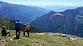
Paragliding and hang-gliding
Speikboden has become world-renowned among cross-country paragliders thanks to Kurt Eder. Although he seldom leaves his home region, the South Tyrolean is a "regular" on the winners’ podium at international XC paragliding championships – a testimony to the excellence of this paragliding location. Speikboden offers a superb XC destination for newcomers to the sport and experienced pilots alike. Flying is possible all year round but the months between June and September offer the best conditions. The panoramas from the launching sites are vast and sweeping; on the south side you can see all the way to the Central Dolomites. Speikboden is located directly to the south of the Zillertal Alpine Divide which means it is poorly shielded from the wind from the north and flying is not recommended if this wind is too strong. The towering Durreck range behind Speikboden does, however, protect the launching areas from moderate north-winds.
 Launching site for paragliders on the Speikboden
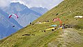 Launching site for paragliders on the Speikboden
 Paragliding in the Speikboden region
 Paragliding in the Speikboden region
 Paragliding in the Speikboden region
 Hang-gliding in the Speikboden region


Hiking
The development of Speikboden as a hiking area began as far back as the 1870s. Founded by Josef Daimer in 1873, the Sand in Taufers section of the German and Austrian Alpine Club[1] constructed the Sonklarhütte refuge and, leading up to the hut, the "Herrenweg" track which was renamed "Daimerweg" in 1903 in honour of Josef Daimer.[2] The construction of the Chemnitzer Hütte mountain hut by the Alpine Club Chemnitz section in 1895 can also be credited to the initiative and untiring efforts of Josef Daimler. The high-altitude trail "Kellerbauerweg" was created in 1906 with the purpose of connecting the two mountain shelters Sonklarhütte and Chemnitzer Hütte.[3]
In the 1990s efforts were rekindled to improve and expand the network of hiking trails centred around the Daimerweg and Kellerbauerweg trails - a process that is still on-going today. The Speikboden massif now boasts 90 kilometres of hiking tracks. The maintenance and further extension of this network are carried out by the employees of the lift company.
 Hiking map Speikboden (2019)
 History of the Daimerweg trail
 Trail construction on the Speikboden at the end of the 1990s and in the early 2000s
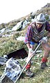 Trail construction on the Speikboden at the end of the 1990s and in the early 2000s
 Trail construction on the Speikboden at the end of the 1990s and in the early 2000s
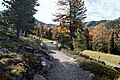 Hiking trails on the Speikboden
 Hiking trails on the Speikboden
 Hiking trails on the Speikboden
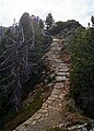 Hiking trails on the Speikboden
 Hiking trails on the Speikboden


- Sonklarhütte
Located to the south of the summit at an altitude of 2,420 m, the Sonklarhütte refuge was originally constructed back in 1876 by the former Sand in Taufers section of the German and Austrian Alpine Club and was named after Carl Sonklar. The hut was built in the space of just a few weeks and was one of the first of its kind in South Tyrol. Initially offering overnight accommodation for just 10 people it quickly proved too small and a new, larger hut was built in 1899. During the First World War the hut remained unmanaged and fell into disrepair after the end of the war. In 1926 the new owner, the Bruneck section of the Italian Alpine Club "CAI", made plans to restore the mountain refuge. This, however, never took place.[4]
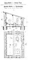 Draft of the Sonklarhütte drawn by Johann Stüdl
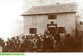 Report on the inauguration of the Sonklarhütte
 The Sonklarhütte on the Speikboden – Josef Daimer
 The Sonklarhütte on the Speikboden as depicted on an old postcard
 Sign beside the ruins of the Sonklarhütte on the Speikboden


Via ferratas
Speikboden via ferrata
The via ferrata on the Speikboden offers a moderately graded yet challenging climb with 350 meters of vertical gain up to the Speikboden summit cross at an altitude of 2,517 m
- Level of difficulty: B/C (moderately difficult)
- Start/finish: Speikboden Alm at 2,000 m, accessible via the Speikboden gondola lift
- Total ascent: 500 vertical meters| walking time: 3 hours
- Access track to the via ferrata: 150 vertical meters | walking time: 40 mins.
- Return walk to the Speikboden Alm lift station:
- Via trail no. 27 | walking time approx. 1 ½ hours
- Via the panorama trail | towards Sonnklarnock: 3 hours or towards Großer Nock: 2 hours
- Using the Sonnklar chairlift | walking time: 30 mins.
- Total time required: Min. 4 hours
- Last descent with the Sonnklar chairlift: 4.30 pm
- Last descent with the Speikboden gondola: 5.00 pm
- Safety and securing aids: Steel ropes, clamps, rope bridge, hanging bridge
- Best time of year: June–October
- Views: Dolomites, Rieserferner Group, Venediger Group, Zillertal Alps
- Equipment: Climbing harness, via ferrata set, helmet, sturdy footwear (rental equipment is available from the Speikboden Alm gondola station)
 Via ferrata
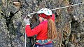 Via ferrata
 Via ferrata
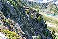 Via ferrata


Speikboden via ferrata for children
The children’s via ferrata on the Speikboden was specially created for kids between the ages of 6 and 12 years. Based on a pirate theme, it offers a child-friendly route for practicing the art of climbing.
- Level of difficulty: A (easy)
- Start/finish: Speikboden Alm at 2,000 m, accessible via the Speikboden gondola lift
- Access track to the via ferrata: 50 vertical metres, 20 mins.
- Ascent: 70 vertical metres, 1 hour
- Total time required: min. 2 hours
- Equipment: Climbing harness, via ferrata set, helmet, sturdy footwear (rental equipment is available from the Speikboden Alm gondola station)
Ski pass association Skiworld Ahrntal
The two ski arenas Speikboden and Klausberg including the two town lifts Weißenbach and Rein in Taufers form together the Skiworld Ahrntal. The ski pass allows to use 21 lifts and 74 kilometers of slopes (from 950 to 2510 meters sea level). In the summer season the association Skiworld Ahrntal exists too. The tickets in summer can be used in the areas Speikboden and Klausberg.
Panoramic view


See also
- List of ski areas and resorts in Europe
References
External links
![]() Media related to Speikboden (South Tyrol) at Wikimedia Commons
Media related to Speikboden (South Tyrol) at Wikimedia Commons
| Authority control: National libraries |
|---|
На других языках
[de] Speikboden (Zillertaler Alpen)
Der Speikboden ist ein zwischen Weißenbachtal, Mühlwalder Tal und Ahrntal liegender Gebirgsstock in den Zentralalpen. Er stellt den östlichen Endpunkt des Mühlwalder Kamms dar, eines Teils der Zillertaler Alpen. Der höchste Punkt erreicht eine Höhe von 2517 m und heißt ebenfalls Speikboden. Weitere benannte Gipfel des Massivs, dessen Namengebung auf den hier häufig auftretenden Speik zurückzuführen ist, sind der Seewassernock (2516 m), der Große Nock (2400 m), der Kleine Nock (2227 m) und der Gornerberg (2475 m).- [en] Speikboden (South Tyrol)
[it] Monte Spico
Monte Spico (2.517 m s.l.m. - Speikboden in tedesco) è un massicco montuoso delle Alpi Centrali situato tra la Valle di Rio Bianco, la Valle di Selva dei Molini e la Valle Aurina. Rappresenta la parte più orientale di un prolungamento verso sud-est delle Alpi della Zillertal occidentali. Il punto più alto raggiunge un'altitudine di 2.517 m s.l.m. ed è chiamato anche Speikboden. Altre cime del massiccio sono il monte Seewassernock (2.516 m s.l.m.), il Dosso Grande (Großer Nock, 2.400 m s.l.m.), il Dosso Piccolo (Kleiner Nock, 2.227 m s.l.m.) e il monte Gornerberg (2.475 m s.l.m.).Другой контент может иметь иную лицензию. Перед использованием материалов сайта WikiSort.org внимательно изучите правила лицензирования конкретных элементов наполнения сайта.
WikiSort.org - проект по пересортировке и дополнению контента Википедии