geo.wikisort.org - Mountains
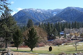
The San Emigdio Mountains are a part of the Transverse Ranges in Southern California, extending from Interstate 5 at Lebec and Gorman on the east to Highway 33–166 on the west. They link the Tehachapis and Temblor Range and form the southern wall of the San Joaquin Valley. The range is named after Emygdius, an early Christian martyr.
| San Emigdio Mountains | |
|---|---|
 Mt. Pinos at top right | |
| Highest point | |
| Peak | San Emigdio Mountain |
| Elevation | 7,492 ft (2,284 m) |
| Coordinates | 34°52′23.912″N 119°10′44.394″W |
| Geography | |
 San Emigdio Mountains Location of San Emigdio Mountains in California[1] | |
| Country | United States |
| State | California |
| County | Kern |
| Parent range | Transverse Ranges |
| Borders on | Tehachapi Mountains and Temblor Range |
Geography
The range is within Kern County. The highest point is San Emigdio Mountain at 7,492 feet (2,284 m). As with most of the Transverse Ranges, the mountains generally lie in an east-west direction.
Towns or settlements near the San Emigdio Mountains include Frazier Park, Lake of the Woods, and Pine Mountain Club.
Highest peaks
- San Emigdio Mountain 7,492 ft (2,284 m)[2]
- Tecuya Mountain 7,160+ ft (2,182+ m)[3]
- Escapula Peak 7,080+ ft (2,158+ m)[4]
- Brush Mountain 7,048 ft (2,148 m)[5]
- Antimony Peak 6,848 ft (2,087 m)[6]
- Eagle Rest Peak 6,005 ft (1,830 m)[7]
Adjacent ranges
Adjacent Transverse Ranges, with their wildlife corridors, include:
- Tehachapi Mountains — on the northeast
- Sierra Pelona Mountains — on the east
- Pine Mountain Ridge - (to the south)
- Topatopa Mountains — on the southwest
- San Rafael Mountains - (to the west)
- Santa Ynez Mountains - (to the southwest)
- San Joaquin Valley — on the north
- Temblor Range - (to the northwest)
See also
- Mountain Communities of the Tejon Pass
- Pyramid Lake
- Index: Transverse Ranges
References
- "San Emigdio Mountains". Geographic Names Information System. United States Geological Survey, United States Department of the Interior. Retrieved 2009-05-04.
- "San Emigdio Mountain". Geographic Names Information System. United States Geological Survey, United States Department of the Interior. Retrieved 2009-05-04.
- "Tecuya Mountain". Geographic Names Information System. United States Geological Survey, United States Department of the Interior. Retrieved 2009-05-04.
- "Escapula Peak". Geographic Names Information System. United States Geological Survey, United States Department of the Interior. Retrieved 2009-05-04.
- "Brush Mountain". Geographic Names Information System. United States Geological Survey, United States Department of the Interior. Retrieved 2009-05-04.
- "Antimony Peak". Geographic Names Information System. United States Geological Survey, United States Department of the Interior. Retrieved 2009-05-04.
- "Eagle Rest Peak". Geographic Names Information System. United States Geological Survey, United States Department of the Interior. Retrieved 2009-05-04.
External links
На других языках
[de] San Emigdio Mountains
Die San Emigdio Mountains sind ein Gebirge in der Transverse Ranges im Los Angeles County, im Kern County und im Ventura County in Südkalifornien. Das 2409 km² große Gebirge hat eine maximale Nord-Süd-Ausdehnung von 64 km und eine maximale Ost-West-Ausdehnung von 65 km. Höchster Punkt des Gebirges ist laut dem United States Geological Survey der 2284 m hohe San Emigdio Mountain,[1] in anderen Quellen wird der 2686 m hohe Mount Pinos als höchster Berg der San Emigdio Mountains angegeben.[2]- [en] San Emigdio Mountains
Текст в блоке "Читать" взят с сайта "Википедия" и доступен по лицензии Creative Commons Attribution-ShareAlike; в отдельных случаях могут действовать дополнительные условия.
Другой контент может иметь иную лицензию. Перед использованием материалов сайта WikiSort.org внимательно изучите правила лицензирования конкретных элементов наполнения сайта.
Другой контент может иметь иную лицензию. Перед использованием материалов сайта WikiSort.org внимательно изучите правила лицензирования конкретных элементов наполнения сайта.
2019-2025
WikiSort.org - проект по пересортировке и дополнению контента Википедии
WikiSort.org - проект по пересортировке и дополнению контента Википедии