geo.wikisort.org - Mountains
Piz Nair (3,056 metres (10,026 ft)) is a mountain of the Albula Alps in Switzerland, overlooking St. Moritz in the canton of Graubünden. The peak is easily accessible from the village with a funicular and a cable car; the upper station unloads 30 metres (100 ft) below the summit. Below the summit to the east is the Corviglia ski area.
| Piz Nair | |
|---|---|
 Piz Nair cable car station in 2006 | |
| Highest point | |
| Elevation | 3,056 m (10,026 ft) |
| Prominence | 183 m (600 ft)[1] |
| Parent peak | Piz Ot |
| Coordinates | 46°30′22.5″N 9°47′14.8″E |
| Geography | |
 Piz Nair Location in Switzerland | |
| Location | Graubünden, Switzerland |
| Parent range | Albula Alps |
| Climbing | |
| Easiest route | Cable car |

Piz Nair
Location of Piz Nair in the Alps of Europe
The mountain hosted the alpine skiing events for the 1948 Winter Olympics in neighboring St. Moritz.[2] It also hosted the World Championships in 1934, 1974, 2003, and 2017.
Gallery
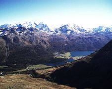 The Engadin Valley from the summit
 Corviglia intermediate station


See also
- List of mountains of Switzerland accessible by public transport
- Corviglia
- St. Moritz–Corviglia Funicular
References
- Retrieved from the Swisstopo topographic maps. The key col is the Fuorcla Schlattain (2,873 m).
- 1948 Winter Olympics official report. pp. 6, 21. (in French and German)
External links
![]() Media related to Piz Nair at Wikimedia Commons
Media related to Piz Nair at Wikimedia Commons
Olympic venues in alpine skiing | ||
|---|---|---|
| 1900s |
|  |
| 2000s |
| |
На других языках
[de] Piz Nair (Albula)
Der Piz Nair (nair stammt vom lateinischen niger und steht im rätoromanischen für ‚schwarz‘[2] und wird im Puter als „Piz När“ ausgesprochen) ist ein 3055 m ü. M.[1] hoher Berg im Kanton Graubünden (Schweiz). Der Gipfel wird oft als Hausberg von St. Moritz (1822 m) bezeichnet und ist ein beliebter Aussichtsberg. Er ist sowohl während der Winter- als auch während der Sommersaison durch eine Luftseilbahn erschlossen.- [en] Piz Nair
[fr] Piz Nair (Albula)
Le Piz Nair est un sommet des Alpes situé dans le canton des Grisons (Suisse) dans la chaîne de l'Albula, au-dessus de Saint-Moritz.[it] Piz Nair (Alpi dell'Albula)
Il Piz Nair (3.057 m) è una montagna situata vicino a Sankt Moritz nelle Alpi dell'Albula nella Svizzera.[ru] Наир (пик)
Пик На́ир (нем. Piz Nair) — гора высотой 3056 м в Ретийских Альпах в районе Санкт-Морица кантона Граубюнден расположенном в юго-восточной части Швейцарии недалеко от границы с Италией.Текст в блоке "Читать" взят с сайта "Википедия" и доступен по лицензии Creative Commons Attribution-ShareAlike; в отдельных случаях могут действовать дополнительные условия.
Другой контент может иметь иную лицензию. Перед использованием материалов сайта WikiSort.org внимательно изучите правила лицензирования конкретных элементов наполнения сайта.
Другой контент может иметь иную лицензию. Перед использованием материалов сайта WikiSort.org внимательно изучите правила лицензирования конкретных элементов наполнения сайта.
2019-2026
WikiSort.org - проект по пересортировке и дополнению контента Википедии
WikiSort.org - проект по пересортировке и дополнению контента Википедии