 Viewed from suburbia (2003)
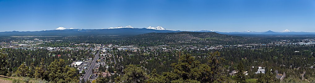 Panoramic view of Bend from the peak (2008)
 Butte ecology (2014)
 The closed Pilot Butte Drive-In (2022)
geo.wikisort.org - Mountains
Pilot Butte is a lava dome that was created from an extinct volcano located in Bend, Oregon. It is a cinder cone butte which rises nearly 500 feet (150 m) above the surrounding plains. Bend is one of six cities in the United States to have a volcano within its boundaries. The other examples are Mount Tabor in Portland, Oregon, Jackson Volcano in Jackson, Mississippi, Diamond Head in Honolulu, Glassford Hill in Prescott Valley and Pilot Knob in Austin, Texas.
| Pilot Butte | |
|---|---|
 | |
| Highest point | |
| Elevation | 4,142 ft (1,262 m) NAVD 88[1] |
| Prominence | 480 ft (150 m)[2] |
| Coordinates | 44°03′38″N 121°17′00″W[1] |
| Geography | |
 Pilot Butte Deschutes County, Oregon, U.S.  Pilot Butte Pilot Butte (Oregon) | |
| Parent range | Cascades |
| Topo map | USGS Bend |
| Geology | |
| Age of rock | Less than 780,000 years[3] |
| Mountain type | Cinder cone |
| Volcanic arc | Cascade Volcanic Arc |
| Climbing | |
| Easiest route | Road |
The 114.22-acre (46.22-hectare) Pilot Butte State Scenic Viewpoint, presented as a gift to the State of Oregon in 1928, is a Bend icon. Pilot Butte itself is a popular hiking destination with two trails to the summit, each gaining about 490 feet (150 m) in elevation. There is also a 1.8-mile (2.9 km) trail around the base of the butte. A scenic road also winds up and around the cone. In 2018, the park was the most visited Oregon state park east of the Cascade Mountains. From the top, the entire city of Bend is visible, as well as several major Cascade peaks. Most prominent are the Three Sisters, Broken Top, and Mount Bachelor, which are located about 20 miles (32 km) to the west. The City of Bend launches Fourth of July fireworks from Pilot Butte each year.[4]
Geology
Pilot Butte formed approximately 188,000 years ago from the eruption of a volcanic vent.[5] The rock has normal magnetic polarity, implying that it was laid down after the most recent geomagnetic reversal about 780,000 years ago.[citation needed] The butte's light-colored soil contains some ash from the eruption of Mount Mazama (which formed Crater Lake).[5]
Ecology
The most common tree on Pilot Butte is Western juniper, which is sometimes parasitized by witches' broom mistletoe. Also abundant are sagebrush and the similar plants bitterbrush and rabbitbrush. The invasive species cheatgrass is likely the most common grass on the butte. Wildflowers that appear include sand lily, rock cress, penstemon, paintbrush, buckwheat, yarrow, blazing star, mariposa lily, lupine, and monkeyflower. Ponderosa pine and red currant can also be found. Birds and deer feed on some of the plants, and some animals use snags as shelter.[5]
History
Pilot Butte was named in 1851 by Thomas Clark, leader of the first party of European settlers to camp on the future site of Bend. The Clark wagon train approached the area from the east after recovering from the Clark massacre.
The butte was gifted to State of Oregon as a public park in 1928 by the daughter of Terrence Hardington Foley, the leader of the local Elks lodge until his death in a 1926 automobile accident, to whom the park is dedicated on a memorial tablet.[6]
In 1983, a drive-in hamburger restaurant called Pilot Butte Drive-In was opened next to the butte on Greenwood Avenue. It remained open until 2020, when it was closed in response to COVID-19 lockdowns.[7] The property was sold and will be reopened as a pizza, beer, and poker establishment.[8]
In 2010, a 1.8-mile (2.9 km) trail was constructed around the base of the butte. The park had 949,968 annual visits in 2018, making it the most visited Oregon State Park east of the Cascade Mountains and the ninth most popular in the state.[9]
Gallery


References
- "Pilot Butte". NGS Data Sheet. National Geodetic Survey, National Oceanic and Atmospheric Administration, United States Department of Commerce. Retrieved April 2, 2008.
- "Pilot Butte, Oregon". Peakbagger.com. Retrieved April 2, 2008.
- "USGS Geologic Investigations Series Map I-2683, pamphlet" (PDF). U.S. Department of the Interior and U.S. Geological Survey. 2004. Retrieved October 28, 2018.
- "July 4th Fireworks Spectacular". Bend Oregon Visitor Bureau for Hotels, Lodging, or Restaurants. Retrieved January 12, 2013.
- "Pilot Butte State Scenic Viewpoint" (PDF). Oregon State Parks. p. 2. Retrieved July 13, 2022.
- "Pilot Butte Is Presented To State For Public Park". Bend Bulletin. October 1, 1928. Archived from the original on August 2, 2017. Retrieved June 28, 2021.
- Bohanan, Anyssa (April 24, 2020). "Pilot Butte Drive-In closes; beloved burger joint future in doubt". Central Oregon Daily. Retrieved July 27, 2022.
- "Pizza, beer, poker club planned for Bend's Pilot Butte Drive-In spot". Central Oregon Daily. March 8, 2022. Retrieved July 27, 2022.
- "The 20 most popular Oregon state parks in 2018". oregonlive.com. The Oregonian. Retrieved April 27, 2020.
External links
Wikimedia Commons has media related to Pilot Butte State Scenic Viewpoint.
- "Pilot Butte". Geographic Names Information System. United States Geological Survey, United States Department of the Interior. Retrieved April 2, 2008.
- "Pilot Butte State Scenic Viewpoint". Oregon Parks and Recreation Department. Retrieved April 1, 2008.
- "Pilot Butte, Oregon". USGS Cascades Volcano Observatory. Retrieved April 1, 2008.
- Pilot Butte State Scenic Viewpoint, from The Oregon Encyclopedia
Protected areas of Oregon | |||||||||||||||||||||||||||||||
|---|---|---|---|---|---|---|---|---|---|---|---|---|---|---|---|---|---|---|---|---|---|---|---|---|---|---|---|---|---|---|---|
| |||||||||||||||||||||||||||||||
| Federal |
| ||||||||||||||||||||||||||||||
| State |
| ||||||||||||||||||||||||||||||
| Local |
| ||||||||||||||||||||||||||||||
| |||||||||||||||||||||||||||||||
На других языках
- [en] Pilot Butte (Oregon)
[fr] Pilot Butte
Pilot Butte est un cône volcanique de l'Oregon, aux États-Unis. Il culmine à 1 261 mètres dans le centre de la ville de Bend, dans le comté de Deschutes. Le sommet peut être atteint par la route. Il offre une vue sur une partie de la chaîne des Cascades, notamment le mont Jefferson, le mont Bachelor et le mont Hood.Текст в блоке "Читать" взят с сайта "Википедия" и доступен по лицензии Creative Commons Attribution-ShareAlike; в отдельных случаях могут действовать дополнительные условия.
Другой контент может иметь иную лицензию. Перед использованием материалов сайта WikiSort.org внимательно изучите правила лицензирования конкретных элементов наполнения сайта.
Другой контент может иметь иную лицензию. Перед использованием материалов сайта WikiSort.org внимательно изучите правила лицензирования конкретных элементов наполнения сайта.
2019-2026
WikiSort.org - проект по пересортировке и дополнению контента Википедии
WikiSort.org - проект по пересортировке и дополнению контента Википедии