geo.wikisort.org - Mountains
Larch Mountain is an extinct volcano[4] near Portland, Oregon. The name is misleading, as no western larch (a large coniferous tree) can be found there.[5] It received that name when early lumbermen sold the noble fir wood as larch. The peak can be reached between May and November on paved Larch Mountain Road, 16 miles (26 km) east of Corbett, Oregon, although the road is closed during the winter and spring months.[6] The road leading to Larch Mountain from the Historic Columbia River Highway is 14 miles long, which closed at milepost 10 from Nov. through late May or early June due to snow.[7]
| Larch Mountain | |
|---|---|
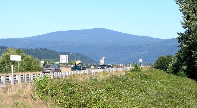 Larch Mountain, as seen from Washougal, Washington. | |
| Highest point | |
| Elevation | 4,061 ft (1,238 m) NAVD 88[1] |
| Prominence | 975 ft (297 m)[2] |
| Coordinates | 45°31′58″N 122°05′16″W[1] |
| Geography | |
| Location | Multnomah County, Oregon, U.S. |
| Topo map | USGS Multnomah Falls |
| Geology | |
| Age of rock | 1.8–1.4 Ma |
| Mountain type | Shield volcano[3] |
| Volcanic field | Boring Lava Field |
| Last eruption | 1.4 Ma |
| Climbing | |
| Easiest route | paved road (June–October) hiking trails (November–May) |

Geography
Larch Mountain is located in Multnomah County, Oregon approximately 40 miles (64 km) east of Portland, above the Columbia River Gorge. Although it has an elevation of 4,061 feet (1,238 m),[1] its prominence above the surrounding terrain is only 975 feet (297 m).[2] The summit of the mountain is accessible by Larch Mountain Road between May and November, which branches off from the Historic Columbia River Highway 2 miles (3.2 km) east of Corbett. Due to the risk of driving on the mountain's upper slopes in winter weather, the road closes during the winter months at milepost 10.[8][9]
History
In 1879, Amos James Moore was the first known person to advocate for the logging and settling of Larch Mountain. Attractive due to its proximity to Portland and the Columbia River, it contained what were considered some of the highest-quality cedar, hemlock, and fir trees in the United States. In 1886, the Bridal Veil Lumbering Company started logging and constructed a lumber mill, followed a year later by the Latourrel Falls Wagon Road and Lumber Company. The operation rapidly expanded with the construction of a wooden plank road extending from Larch Mountain to the railroad line near the river, allowing for the large-scale logging of the mountain. The Bridal Veil Lumbering company became known for the high quality of its timber.[10]
In 1902, a fire swept through one of the mills, completely destroying it as well as the town. Both were soon rebuilt in new locations. This event is often heralded as the start of the decline of the large-scale Victorian logging practices, which were replaced by more modern techniques. Only a few remnants of the former system exist today. Logging continued in the new forms on the mountain for several more decades. In 1928, the United States Forest Service began reforesting the slopes of Larch Mountain, so that more lumber could be produced. A fire in 1936 marked the end of the timber business on the mountain. Causing around $100,000 of damage, it severely damaged the lumber mill, which was not rebuilt due to the depletion of the timber supply on the mountain.[10]
Geology
Larch Mountain is the remnant of an ancient shield volcano, with broad slopes covering tens of square kilometers. It is currently the tallest peak in the Boring Lava Field, a volcanic field active during the Plio-Pleistocene time frame. Active between 1.8 and 1.4 million years ago, the volcano is composed mainly of basalts, although the summit at Sherrard Point is composed mainly of iron-rich andesite. Larch Mountain's basalt is tough to distinguish from the surrounding Columbia River Basalt, although the Columbia River Basalt is slightly lighter in color and less brittle.[11] Sherrard Point is the eroded remains of the original volcanic plug.[12]
Sherrard Point was exposed during the last glacial period, when the majority of the mountain's peak was destroyed by glaciers. The glaciers carved a large cirque into the mountain, forming a large lake. Over time, the lake was filled with sediment, and today the area is now a large meadow.[13]
Biology
Larch Mountain contains some of the largest old-growth forest stands left in the Columbia River Gorge area, characterized by the presence of many nurse logs. Dominant tree species include pacific silver fir, grand fir, Douglas fir, and western hemlock.[13]
Recreation
The Larch Mountain area contains multiple popular hiking trails. The Larch Mountain Trail #441 begins near the Columbia River at the Multnomah Falls Lodge and roughly follows Multnomah Creek, passing several waterfalls including the well-known Multnomah Falls, Weisendanger Falls, and Ecola Falls. The trail ends at the Larch Mountain parking lot,[14] at a picnic area.[6] The Sherrard Point Trail #443 leads from this area to Sherrard Point at the pinnacle.[14] Sherrard Point offers an outstanding view of the nearby Cascade Range volcanoes Mount Hood, Mount Adams, Mount Jefferson, Mount Rainier, and Mount St. Helens. Elevation plaques are provided, showing the elevation of said volcanoes.
A loop around Larch Mountain itself is formed by the Larch Mountain Trail, the Multnomah Creek Way Trail #444, and the Oneonta Trail #424.[15]
Gallery
 View from the summit with Mount Hood in the distance.
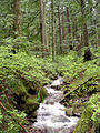 A creek in Larch Mountain forest.
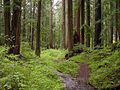 Old-growth forest
 Larch Mountain Trail plaque
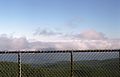 View of Mt St Helens from the summit of Larch Mountain


See also
References
- "Larch Reset". NGS data sheet. U.S. National Geodetic Survey. Retrieved 2008-11-18.
- "Larch Mountain, Oregon". peakbagger.com. Retrieved 2008-04-01.
- "The Boring Volcanic Field – Hills of the Portland Basin". USGS Cascades Volcano Observatory. Retrieved 2015-12-29.
- Cascades Volcano Observatory (2014-06-11). "The Boring Volcanic Field — Hills of the Portland Basin". USGS. Retrieved 2015-02-21.
All existing Boring Volcanic centers are extinct, but the Boring Volcanic Field presumably is not. Since activity started 2.6 million years ago, it is rare that 50,000 years passed without an eruption. The probability of an eruption in the Portland/Vancouver metro area however, is very low.
- Reed, Ione (1971-12-25). "What, Indeed, Is in a Name?". Eugene Register-Guard. p. 8. Retrieved 2015-04-30.
- "Larch Mountain Picnic Area". United States Forest Service. Retrieved 2015-08-11.
- "Larch Mountain Trail (#441)". 2022-01-15. Retrieved 2022-01-15.
{{cite web}}: CS1 maint: url-status (link) - House, Kelly (2015-11-20). "Upper Larch Mountain Road to close for winter next week". The Oregonian. Portland, Oregon. Retrieved 2015-12-28.
- "Larch Mountain Trailhead". United States Forest Service. Retrieved 2015-12-28.
- Prohaska, Sharr (1992). History of the Development of Bridal Veil, Oregon and the Bridal Veil Lumbering Company: Report for Multnomah County (PDF) (Report) (June ed.).
- Bishop, Ellen Morris; Allen, John Eliot (2004). Hiking Oregon's Geology (Second ed.). The Mountaineers Books. pp. 108–110. ISBN 9780898868470.
- Hart, Steve (2015-02-26). "Sherrard Point". OregonHikers.org. Retrieved 2015-08-11.
- Lorain, Douglas (2008-03-05). Afoot and Afield: Portland/Vancouver: A Comprehensive Hiking Guide. Berkeley, California: Wilderness Press. pp. 217–219. ISBN 978-0-89997-468-2.
- Hart, Steve (2010-02-18). "Larch Mountain Hike". OregonHikers.org. Retrieved 2015-12-20.
- "Multnomah Creek Way Trail #444". United States Forest Service. Retrieved 2015-12-21.
Другой контент может иметь иную лицензию. Перед использованием материалов сайта WikiSort.org внимательно изучите правила лицензирования конкретных элементов наполнения сайта.
WikiSort.org - проект по пересортировке и дополнению контента Википедии