geo.wikisort.org - Mountains
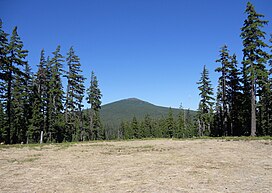
Maiden Peak is a steep-sided shield volcano in the Cascade Range of central Oregon. It is the highest point in the 43-mile (69 km) distance between Mount Bachelor and Diamond Peak. Ice Age glaciers carved a large cirque into the northeast flank of the mountain, exposing magma which hardened in the volcano's conduits to form the numerous rock pinnacles now found in the upper part of the cirque.
| Maiden Peak | |
|---|---|
 Maiden Peak as seen from the north side of Eagle Peak | |
| Highest point | |
| Elevation | 7,823 ft (2,384 m) NAVD 88[1] |
| Prominence | 2,578 ft (786 m)[2] |
| Coordinates | 43°37′37″N 121°57′53″W[1] |
| Geography | |
 Maiden Peak Location in Oregon | |
| Location | Deschutes / Lane counties, Oregon, U.S. |
| Parent range | Cascades |
| Topo map | USGS The Twins |
| Geology | |
| Age of rock | Less than 250,000 years old[3] |
| Mountain type | Shield volcano |
| Climbing | |
| Easiest route | Trail |
The summit of Maiden Peak consists of a steeper cinder cone which sits atop the underlying shield volcano. It is located on the Cascade Crest, which forms the boundary between Lane County and Deschutes County.[4] Also, it is on the boundary between the Deschutes National Forest and the Willamette National Forest.[2] A Forest Service fire lookout tower was built on the summit in 1923, but was removed in 1958.[5] A 5.8-mile (9.3 km) trail zigzags up to the summit from the southwest.
References
- "Maiden". NGS data sheet. U.S. National Geodetic Survey. Retrieved 2016-04-26.
- "Maiden Peak, Oregon". Peakbagger.com. Retrieved 2008-04-01.
- Wood, Charles A.; Jűrgen Kienle (1993). Volcanoes of North America. Cambridge University Press. p. 354. ISBN 0-521-43811-X.
- "Maiden Peak". Geographic Names Information System. United States Geological Survey. Retrieved 2008-11-16.
- "Maiden Peak Lookout Site". Forest Fire Lookout Association. Archived from the original on 2016-04-27. Retrieved 2016-04-29.
Further reading
- Harris, Stephen L. (2005). Fire Mountains of the West: The Cascade and Mono Lake Volcanoes (3rd ed.). Mountain Press Publishing Company. ISBN 0-87842-511-X.
- Kresek, Ray (1998). Fire Lookouts of the Northwest (3rd ed.). Historic Lookout Project. ISBN 0-87770-632-8.
- "Maiden Peak, Oregon". Volcano World. Archived from the original on 2009-02-04. Retrieved 2008-12-19.
- "Maiden Peak". Global Volcanism Program. Smithsonian Institution. Retrieved 2021-06-28.
На других языках
- [en] Maiden Peak (Oregon)
[fr] Pic Maiden
Le pic Maiden, en anglais : Maiden Peak, est un volcan bouclier culminant à 2 383 mètres d'altitude dans le centre de l'Oregon, au Nord-Ouest des États-Unis. Il fait partie de la chaîne des Cascades et se trouve à la limite de la forêt nationale de Willamette et de la forêt nationale de Deschutes. Fréquenté depuis des siècles par les Amérindiens, son sommet a constitué au début du XXe siècle un point de vue destiné à l'observation des feux de forêt.Другой контент может иметь иную лицензию. Перед использованием материалов сайта WikiSort.org внимательно изучите правила лицензирования конкретных элементов наполнения сайта.
WikiSort.org - проект по пересортировке и дополнению контента Википедии
