geo.wikisort.org - Mountains
Mount Pulag (Filipino: Bundok Pulag; Ilocano: Bantay Pulag)[3] is Luzon's highest peak at 2,928 metres (9,606 ft) above sea level, third-highest mountain in the Philippines, and the 26th-highest peak of an island on Earth. It is second-most prominent mountain in the Philippines, it is a dormant volcano. Located on the triple border of the provinces of Benguet, Ifugao, and Nueva Vizcaya, the borders meet at the mountain's peak. Mount Pulag is third highest next to Mount Apo and Mount Dulang-dulang.[4]

| Mount Pulag | |
|---|---|
| |
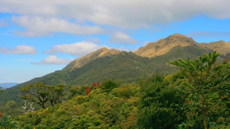
 Sea of clouds, as seen
from Mount Pulag summit | |
| Highest point | |
| Elevation | 2,928 m (9,606 ft)[1][2] |
| Prominence | 2,928 m (9,606 ft)[2] Ranked 107th |
| Isolation | 668 km (415 mi) |
| Listing |
|
| Coordinates | 16°35′0.86″N 120°53′0.93″E |
| Geography | |
 Mount Pulag Location within the Philippines  Mount Pulag Mount Pulag (Philippines) | |
| Location | Luzon |
| Country | Philippines |
| Regions | Cordillera Administrative Region and Cagayan Valley |
| Provinces | Benguet, Ifugao and Nueva Vizcaya |
| Municipalities | Bokod, Kabayan, Kayapa and Tinoc |
| Parent range | Cordillera Central |
| Climbing | |
| First ascent | c. 2000 BC by the native Ibalois. |
| Easiest route | Ambangeg Trail |
Mount Pulag is famous for its "sea of clouds" and its exceptional view of the Milky Way Galaxy at dawn, which has attracted many tourists who wish to see the "other-worldly" scenery.
The entire mountain is believed to be the home to the tinmongao spirits and is the sacred resting ground of the souls of the Ibaloi people and other ethnic peoples in the area.[5]
History
The Ibaloi people of Benguet mummify their dead and house them in caverns in the mountain. The Kabayan mummy burial caves, one of the main attraction of the site, are considered Philippine national cultural treasures under Presidential Decree No. 432.[6]
Mt. Pulag was proclaimed a national park through Presidential Proclamation No. 75 on February 20, 1987 covering an area of 11,550 hectares (28,500 acres).[7] It is part of the Cordillera Biogeographic Zone and is a National Integrated Protected Areas Programme (NIPAP) site.[8]
The national park is inhabited by different ethnic groups such as the Ibalois, Kalanguya, Kankana-eys, Karao, and Ifugaos.[9]
Geography
Mount Pulag stands at 2,928 metres (9,606 ft) high.[1] The peak of the mountain is located in the Municipality of Kabayan Province of Benguet.
Climate
The climate at the summit of Mount Pulag is subpolar oceanic (Köppen Cwc), bordering a subtropical highland (Köppen Cwb) climate, as its summer mean temperatures only slightly exceed 10 degrees Celsius. Rainfall on the mountain averages 4,489 millimetres (176.7 in) yearly with August being the wettest month with an average rainfall of 1,135 millimetres (44.7 in). Snow has not fallen on its top in at least the past 100 years, only hailstorms that look like snow. However, there have been mild flurries on the mountain, especially during December, January and February. [clarification needed] Frost is more common on the mountain due to the low temperature during those months.[10] During the winter season, the temperature at the highest point of the mountain is known to dip into sub-freezing temperatures, making it the coldest place in the country.[11] The only recorded incidence of snow was in the late 1800s.[citation needed]
| Climate data for Mount Pulag | |||||||||||||
|---|---|---|---|---|---|---|---|---|---|---|---|---|---|
| Month | Jan | Feb | Mar | Apr | May | Jun | Jul | Aug | Sep | Oct | Nov | Dec | Year |
| Average high °C (°F) | 9.3 (48.7) |
10.3 (50.5) |
12.3 (54.1) |
13.3 (55.9) |
13.3 (55.9) |
12.3 (54.1) |
12.3 (54.1) |
11.3 (52.3) |
12.3 (54.1) |
12.3 (54.1) |
11.3 (52.3) |
9.3 (48.7) |
11.6 (52.9) |
| Daily mean °C (°F) | 5.8 (42.4) |
6.8 (44.2) |
8.3 (46.9) |
9.8 (49.6) |
10.3 (50.5) |
9.8 (49.6) |
10.3 (50.5) |
9.3 (48.7) |
9.8 (49.6) |
8.8 (47.8) |
7.8 (46.0) |
6.3 (43.3) |
8.6 (47.4) |
| Average low °C (°F) | 2.3 (36.1) |
3.3 (37.9) |
4.3 (39.7) |
6.3 (43.3) |
7.3 (45.1) |
7.3 (45.1) |
7.3 (45.1) |
7.3 (45.1) |
7.3 (45.1) |
5.3 (41.5) |
4.3 (39.7) |
3.3 (37.9) |
5.5 (41.8) |
| Average precipitation mm (inches) | 38 (1.5) |
57 (2.2) |
77 (3.0) |
141 (5.6) |
390 (15.4) |
355 (14.0) |
426 (16.8) |
441 (17.4) |
426 (16.8) |
259 (10.2) |
97 (3.8) |
57 (2.2) |
2,764 (108.9) |
| Source: meteoblue.com[12] | |||||||||||||
Fauna and flora


Mount Pulag has a large diversity of flora and fauna, including many species that endemic to the mountain.[13] Mount Pulag hosts 528 documented plant species. It is the natural habitat of the dwarf bamboo (Yushania niitakayamensis) and the Benguet pine (Pinus kesiya) that dominate the areas of Luzon tropical pine forests found on the mountainsides. The Philippine yew tree, which contains a compound associated with cancer treatment, is found on Mount Pulag.[14] Its bark is used by indigenous Ibaloi and Kalanguya communities to make tea.[15]
At lower elevations, Mount Pulag has a mossy forest full of ferns, lichens, and moss.[13]
Among its native wildlife are 33 bird species and several threatened mammals such as the Philippine deer, giant bushy-tailed cloud rat (bowet) and the long-haired fruit bat.[8] Mount Pulag is the only place that hosts the four cloud rat species. It is one of the most biodiverse locations in the Philippines, with the newly found (since 1896) 185-grams dwarf cloud rat, Carpomys melanurus, a rare breed (endemic to the Cordillera), and the Koch pitta bird among its endangered denizens.
Conservation efforts
In April 2022, President Rodrigo Duterte signed a law declaring Mount Pulag as a protected landscape under the National Integrated Protected Areas System.[16]
Hiking activity

As the highest mountain in Luzon, Mount Pulag attracts a lot of mountain climbers.[8] Highlights of the climb include the montane forests and the grassland summit with its "sea of clouds" phenomenon. There are four major trails up the summit: the Ambangeg, Akiki, and Tawangan trails from Benguet and the Ambaguio trail from Nueva Vizcaya. These trails are managed by the Mount Pulag National Park, under the Department of Environment and Natural Resources.
Incidents
Presidential helicopter crash
On April 7, 2009, a Philippine Air Force (PAF) Bell 412 of the 250th Presidential Airlift Wing crashed at 6,900 feet (2,100 m) above sea level in the Kabayan-Pulag pass between Mount Mangingihi and Mount Pulag in thick low cloud and fog. The aircraft pilots and their passengers, who were presidential appointees, died in the crash.[17]
January 2018 forest fire
On January 20, 2018, the Mount Pulag National Park temporarily suspended trekking and hiking activities on Mount Pulag following a forest fire at a section of the mountain. According to an initial investigation, the fire started when a butane gas stove brought by a hiker allegedly exploded. The fire officers in site have declared a fire extinguished later that day.[18][19] Suits were afterwards filed against the perpetrators of the fire. Park rangers estimated that it will take at least 6 months to 1 year before the area completely recovers.[20]
See also
- List of mountains in the Philippines
- List of national parks of the Philippines
- List of Southeast Asian mountains
References
- "Inactive Volcanoes; Part 6". Philippine Institute of Volcanology and Seismology. 30 July 2008. Archived from the original on 22 March 2016. Retrieved 24 March 2016.
- de Ferranti, Jonathan; Maizlish, Aaron. "Philippine Mountains – 29 Mountain Summits with Prominence of 1,500 Meters or Greater". Archived from the original on 17 February 2015. Retrieved 31 January 2011.
- "Highest Mountains of the Philippines!". Tagalog Lang. July 25, 2015. Archived from the original on January 23, 2022. Retrieved November 10, 2019.
- Lasco, Gideon (January 24, 2016). "The 10 Highest Mountains in the Philippines (2016 Update)". Pinoy Mountaineer. Archived from the original on January 22, 2018. Retrieved January 22, 2018.
- "Benguet Folk to Appease Mount Pulag Spirits". The Manila Times. Archived from the original on 2019-09-21. Retrieved 2019-11-10.
- Cariño, Delmar (27 April 2009). "Respect Mummies, Pulag Trekkers Told". Inquirer.net. Archived from the original on 28 April 2009. Retrieved 5 March 2012.
- "Proclamation No. 75; Declaring As Mount Pulag National Park Certain Parcels of Land of the Public Domain Embraced and Situated in the Municipalities of Buguias and Kabayan in Benguet, Kiangan in Ifugao and Kayapa in Nueva Viscaya, Island of Luzon". Official Gazette of the Republic of the Philippines. 20 February 1987. Archived from the original on 5 October 2016. Retrieved 4 October 2016.
- Leprozo, Dave, Jr. (25 December 2009). "Mapping out Mount Pulag". GMA News Online. Archived from the original on 4 October 2016. Retrieved 4 October 2016.
- McShane, Thomas O.; Wells, Michael P., eds. (2004). Getting Biodiversity Projects to Work: Towards More Effective Conservation and Development. New York: Columbia University Press. p. 186. ISBN 978-0-231-12764-6.
- Ilao, Micaella (19 January 2017). "Mt. Pulag Temperature Drops to 1 Degree Celsius". ABS-CBN News. Archived from the original on 6 August 2019. Retrieved 6 August 2019.
- Dumlao, Artemio (29 December 2015). "Mt. Pulag Freezes Below Zero". Philstar Global. Archived from the original on 1 August 2019. Retrieved 6 August 2019.
- "Climate: Modelled Mount Pulag – Climate graph, Temperature graph, Climate table". meteoblue.com. Archived from the original on 10 November 2019. Retrieved 10 Nov 2019.
- "Mt. Pulag National Park". UNESCO World Heritage Centre. Archived from the original on 2021-02-10. Retrieved 2020-06-26.
- Bengwayan, Michael A. (2019-03-05). "Companies Rush to Patent Wildlife of the Philippines". Eurasia Review (OpEd). Archived from the original on 2020-06-26. Retrieved 2020-06-26.
- Bengwayan, Michael A. (2018-07-29). "PHL Biodiversity Under Siege from Biopirates". Business Mirror. Archived from the original on 2020-06-28. Retrieved 2020-06-26.
- Aning, Jerome (April 29, 2022). "Pulag, Tirad Pass, 3 others declared protected areas". Philippine Daily Inquirer. Archived from the original on April 29, 2022.
- Yagumyum, Rudy (16 April 2009). "PAF Provides More Details on Presidential Chopper Crash". ABS-CBNNews.com. Archived from the original on 10 August 2014. Retrieved 5 March 2012.
- Comanda, Zaldy (21 January 2018). "Mt. Pulag Closed to Hikers Due to Forest Fire". Manila Bulletin. Archived from the original on 23 January 2018. Retrieved 22 January 2018.
- "Hikers, Trekkers Barred from Mount Pulag After Forest Fire". ABS-CBN News. 20 January 2018. Archived from the original on 21 January 2018. Retrieved 22 January 2018.
- Agoot, Liza (20 January 2018). "Activities at Mt. Pulag Suspended Due to Forest Fire". Philippine News Agency. Archived from the original on 22 January 2018. Retrieved 22 January 2018.
External links
- Mount Pulag National Park – BirdLife Data Zone
World Heritage Sites in the Philippines | ||
|---|---|---|
| Cultural |
| |
| Natural |
| |
На других языках
[de] Pulag
Mount Pulag (auch bekannt unter dem Namen Mount Pulog) ist der dritthöchste Berg auf den Philippinen und der höchste Gipfel auf der nördlichen Hauptinsel Luzon und liegt im südlichen Zentrum der Cordillera Central. Am Gipfel treffen die Grenzen der Provinzen Benguet, Ifugao und Nueva Vizcaya aufeinander. Die historischen Höhlenbegräbnisstätten der Ibaloi liegen teilweise an den Flanken des Berges, in ihnen wurden im Mittelalter die Kabayan-Mumien beigesetzt.- [en] Mount Pulag
Другой контент может иметь иную лицензию. Перед использованием материалов сайта WikiSort.org внимательно изучите правила лицензирования конкретных элементов наполнения сайта.
WikiSort.org - проект по пересортировке и дополнению контента Википедии