 Boardwalk on the western side of the crater.
 Boardwalk on the northern side of the crater.
 Boardwalk on the eastern side of the crater.
geo.wikisort.org - Mountains
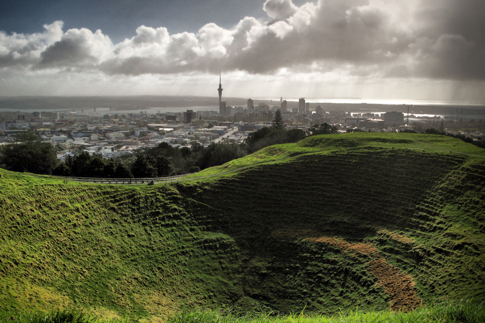
Maungawhau / Mount Eden is a scoria cone and Tūpuna Maunga (ancestral mountain) in the Mount Eden suburb of Auckland, New Zealand.
| Maungawhau[1] | |
|---|---|
| Mount Eden | |
 Looking into and over the crater. | |
| Highest point | |
| Elevation | 196 m (643 ft) |
| Coordinates | -36.877167 174.76431 |
| Geography | |
| Location | Auckland, North Island, New Zealand |
| Parent range | Auckland volcanic field |
| Geology | |
| Volcanic arc/belt | Auckland volcanic field |
Geography
The cone is a dormant volcano and its summit, at 196 metres (643 ft) above sea level, is the highest natural point on the Auckland isthmus. The majestic bowl-like crater is 50 metres (160 ft) deep. The volcano erupted from three craters 28,000 years ago, with the last eruptions from the southern crater filling the northern craters.[2] The western face of the hill was extensively quarried. This is the site of a large ecological restoration project run by volunteers.[3]
Naming
Maungawhau is a Māori-language name meaning 'mountain of the whau tree (Entelea arborescens)'. The name "Mount Eden" was chosen by Governor William Hobson, to honour George Eden, 1st Earl of Auckland, who was his superior naval officer.[4] The crater is named Te Upu Kai a Mataaho ('the bowl of Mataaho'); Mataaho was a deity said to live in the crater and to be the guardian of the secrets hidden in the earth.[5][6]
Treaty settlement

In the 2014 Treaty of Waitangi settlement between the Crown and the Ngā Mana Whenua o Tāmaki Makaurau collective of 13 Auckland iwi and hapu (also known as the Tāmaki Collective), ownership of the 14 Tūpuna Maunga of Tāmaki Makaurau / Auckland, was vested to the collective, including the volcano officially named Maungawhau / Mount Eden. The legislation specified that the land be held in trust "for the common benefit of Ngā Mana Whenua o Tāmaki Makaurau and the other people of Auckland". The Tūpuna Maunga o Tāmaki Makaurau Authority or Tūpuna Maunga Authority (TMA) is the co-governance organisation established to administer the 14 Tūpuna Maunga. Auckland Council manages the Tūpuna Maunga under the direction of the TMA.[7][8][9][10][11][12]
Tourism and access
Maungawhau / Mount Eden attracts many tourists, as it is the highest natural point in Auckland, and provides good views in all directions over the city. Due to the spiritual and cultural significance of the maunga to Māori, and for pedestrian safety, the summit road was permanently closed to most vehicles in 2011, with the exception of people with limited mobility.[13][14][15][16]
In 2019, the 1926 Spanish Mission-style tearoom was converted into Whau Cafe and the Te Ipu Kōrero o Maungawhau / Mount Eden Visitor Experience Centre. The centre showcases the geological and Māori cultural history of the maunga.[17]
In 2020, boardwalks were opened around the crater rim, to protect the pā tūāpapa (terraces) and rua kūmara (kūmara storage pits) on the summit's upper slopes. Views from the boardwalk into the deep crater and over Auckland city are spectacular.[17]


Other uses
In the early 20th Century, stone was quarried by Mount Eden Prison inmates from Maungawhau / Mount Eden for use in road projects.[18]
From the 1950s the peak was used by the New Zealand Post Office for VHF radio communications in two buildings, several hundred metres apart, each with their own antenna farm. One building housed transmitting equipment, while the other housed receiving equipment. In the 1960s the site was staffed during the five-day working week due to the large number of valves that wore out under the stress of high power and needed frequent servicing. Typical use of the facility was for businesses e.g. taxi or delivery firms needing mobile communications to vehicles.
An underground water reservoir has been located on the northern side of Maungawhau / Mount Eden since the 1870s. The original reservoir was replaced in 1912, and a second, complementary, reservoir added in 1930. The reservoirs, recently upgraded to meet growing demand, work together to supply the Mount Eden, Epsom, One Tree Hill and Khyber Pass areas.[citation needed]
The trig station at the summit was used as a reference point for drawing up Auckland's suburbs. The platform was built with help from Prince Alfred's elephant. The elephant was rewarded with lollies, buns and beer.[19]
References
- Tūpuna Maunga o Tāmaki Makaurau Authority (23 June 2016). "Integrated Management Plan" (PDF). Auckland Council. Retrieved 6 October 2021.
- "Chronology of Events" (PDF). Maungawhau-Mt Eden Management Plan (Report). Auckland City Council. February 2007. p. 70. Archived from the original (PDF) on 2008-10-16. Retrieved 2009-05-16.
- "Batger Quarry Restoration Project". Friends of Maungawhau. Retrieved 3 April 2015.
- Cameron, Ewen; Hayward, Bruce; Murdoch, Graeme (2008). A Field Guide to Auckland: Exploring the Region's Natural and Historical Heritage (Revised ed.). Random House New Zealand. p. 210. ISBN 978-1-86962-1513.
- "Maungawhau". Te Ara. Retrieved 3 April 2015.
- "Mataaho". Retrieved 3 April 2015.
- Dearnaley, Mathew (27 September 2014). "Volcanic cones regain Maori names". The New Zealand Herald. Retrieved 25 October 2014.
- "Ngā Mana Whenua o Tāmaki Makaurau Collective Redress Act 2014". New Zealand Legislation. Retrieved 25 October 2014.
- "Ngā Mana Whenua o Tāmaki Makaurau Collective Redress Act 2014 registration guideline" (PDF). Land Information New Zealand. Archived from the original (PDF) on 29 October 2014. Retrieved 25 October 2014.
- "NZGB decisions - September 2014". Land Information New Zealand. Archived from the original on 29 October 2014. Retrieved 25 October 2014.
- "Protection of tupuna maunga assured under ownership transfer". Auckland Council. Retrieved 25 October 2014.
- "New governance structure for treasured tūpuna maunga". Auckland Council. Retrieved 25 October 2014.
- "Changes to vehicle access on Tūpuna Maunga". Auckland Council. Retrieved 4 January 2020.
- "Car ban planned for volcanic cone". Radio New Zealand. 2 December 2014. Retrieved 3 April 2015.
- "The Maunga Authority agreed to stop cars driving to the summit of Maungawhau". Te Kāea. Māori Television. 21 April 2015. Retrieved 21 April 2015.
- "Mt Eden goes vehicle-free". Retrieved 2016-01-15.
- "Boardwalk empire: New chapter for historic Mt Eden volcano". NZ Herald. Retrieved 2022-07-18.
- Bartley, Bryan (2011). "Roads". In La Roche, John (ed.). Evolving Auckland: The City's Engineering Heritage. Wily Publications. pp. 105–109. ISBN 9781927167038.
- McFadden, Suzanne. "Auckland's 175th anniversary: Volcanoes, elephant built the city". The New Zealand Herald. Retrieved 3 April 2015.
- Volcanoes of Auckland: A Field Guide. Hayward, B.W.; Auckland University Press, 2019, 335 pp. ISBN 0-582-71784-1.
External links
- Pronunciation
- Friends of Maungawhau website
- Photographs of Maungawhau held in Auckland Libraries' heritage collections.
| Central Auckland |
|  |
|---|---|---|
| East Auckland |
| |
| South Auckland |
| |
| Waitematā Harbour and North Shore | ||
На других языках
[de] Mount Eden (Vulkan)
Mount Eden (Māori: Maungawhau, „Berg des Whau-Baumes“) ist der Name eines Schlackenkegels in Auckland City auf der Nordinsel Neuseelands. Der Berg befindet sich etwa fünf Kilometer südlich des Stadtzentrums und ist vom Vorort Mount Eden umgeben. Der Berg ist die höchste natürliche Erhebung von Auckland. Er erhielt seinen englischen Namen zu Ehren von George Eden, 1. Earl of Auckland.- [en] Maungawhau / Mount Eden
[fr] Maungawhau/Mont Eden
Le Maungawhau/mont Eden, de son nom en maori de Nouvelle-Zélande et de l'anglais Mount Eden, est un volcan endormi de Nouvelle-Zélande. Il est le plus haut sommet naturel de la ville d'Auckland avec 196 mètres d'altitude. Il donne son nom à l'un des faubourgs d'Auckland situés à son pied, Mount Eden, ainsi qu'au stade Eden Park.Текст в блоке "Читать" взят с сайта "Википедия" и доступен по лицензии Creative Commons Attribution-ShareAlike; в отдельных случаях могут действовать дополнительные условия.
Другой контент может иметь иную лицензию. Перед использованием материалов сайта WikiSort.org внимательно изучите правила лицензирования конкретных элементов наполнения сайта.
Другой контент может иметь иную лицензию. Перед использованием материалов сайта WikiSort.org внимательно изучите правила лицензирования конкретных элементов наполнения сайта.
2019-2025
WikiSort.org - проект по пересортировке и дополнению контента Википедии
WikiSort.org - проект по пересортировке и дополнению контента Википедии