geo.wikisort.org - Mountains
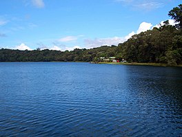
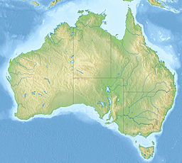
Lake Barrine is a freshwater lake on the eastern parts of Atherton Tableland in the locality of Lake Barrine, in the Tablelands Region of Far North Queensland, Australia, close to Lake Eacham. The lake and surrounds are protected within the Crater Lakes National Park and are accessible via the Gillies Highway.[1]
| Lake Barrine (Barany) | |
|---|---|
 View from a cruise | |
| Location | Lake Barrine, Queensland |
| Coordinates | 17°15′01″S 145°38′07″E |
| Type | Crater lake |
| Primary inflows | precipitation |
| Basin countries | Australia |
| Max. width | 1,230 m (4,040 ft) |
| Average depth | 35 m (115 ft) |
| Max. depth | 65 m (213 ft) |
| Shore length1 | 4.5 km (2.8 mi) |
| Surface elevation | 730 m (2,400 ft) |
| 1 Shore length is not a well-defined measure. | |
Origin
Lake Barrine was formed over 17,000 years ago[2] when a large volcano erupted, leaving a crater that over time filled up with water to create a lake. The crater or maar was formed as a result of a series of volcanic explosions. These explosions were caused by the hot molten rock coming into contact with groundwater. This caused a build-up of steam, gases and pressure which blasted the central core from the volcano. This massive explosion left a huge crater, which filled with rainwater to create Lake Barrine. Local Aboriginals called the lake Barany.[1]
Description

The largest of the natural volcanic lakes in the area, Lake Barrine is 730 m above sea level. It is about 1 km in diameter, with a shoreline of almost 4.5 km, an average depth of 35 m and a maximum depth of 65 m.[3] No streams or springs feed the crystal clear lake; it is filled only by rainwater. During the wet season a small creek flows out of the lake. It joins Toohey Creek which is a tributary of the Mulgrave River.[1]
Facilities
There are walking tracks around the lake and tour operators offer cruises on the lake.[4] Facilities at the lake include picnic grounds, a kiosk and a pre-war tea house which was built in 1926.[1] Visitors may also swim in the lake and partake in birdwatching. Camping and domestic animals are prohibited near the lake.
Fauna and flora

The surrounding rainforest contains giant kauri (Agathis microstachya), red cedar (Toona ciliata) and flowering umbrella trees (Schefflera actinophylla). Wildlife common in the area include eastern water dragons, giant eels, saw-shelled turtles, scrub pythons (Morelia kinghorni), pied cormorants, black ducks, plumed whistling ducks, black coot, whistling kites, brahminy kites, black kites, white-breasted sea eagles and dusky moorhens.
The aquatic environment include a few native species including Speckled_longfin_eel Anguilla Reinhardtii, Bony Bream Nematalosa ereb and the Lake Eacham rainbowfish Melanotaenia eachamensis. Despite being lake with no rivers or creeks feeding into Lake Barrine the spotted tilapia Tilapia mariae has found its way into the National Park and are now in plague proportions in this freshwater Ecosystem.[5]
World War II
During World War II the teahouse was used by the Australian Army as a convalescent home.[6]
See also
- List of lakes of Australia
- List of volcanoes in Australia
- Mount Hypipamee Crater
References
- Shilton, Peter (2005). Natural areas of Queensland. Mount Gravatt, Queensland: Goldpress. pp. 48–51. ISBN 0-9758275-0-2.
- Head, M. J.; Taylor, L. J.; Walker, D. (1994). "ANU Radiocarbon Date List XI: Radiocarbon Dates from Lakes Barrine and Eacham, Atherton Tableland, North Queensland, Australia". Radiocarbon. 36 (1): 73–94. doi:10.1017/S003382220001434X. ISSN 0033-8222.
- Timms, B.V. (1976). "Morphology of Lakes Barrine, Eacham and Euramoo, Atherton Tableland, North Queensland". Proceedings of the Royal Society of Queensland. 87: 81–84.
- About Lake Barrine. Department of National Parks, Recreation, Sport and Racing. Retrieved on 29 December 2012.
- Brandel, Phil (16 January 2020). "Tilapia at plague proportions". The Express. Retrieved 27 January 2022.
- Official website Accessed 22 September 2013
External links
| Wikimedia Commons has media related to Lake Barrine. |
- Queensland National Parks webpage : nature, culture and history
- Scragg, Sarah (12 October 2018). "Jim Curry Digital Story". Vimeo. Sarahscragg Productions. Retrieved 19 October 2018.
- Image of the lake, bird's eye view at the Library of Congress Web Archives (archived 18 November 2008)
- Image of the teahouse at the Wayback Machine (archived 8 March 2005)
- Map of the area at the Wayback Machine (archived 22 July 2005)
На других языках
[de] Lake Barrine
Der Lake Barrine ist ein mit Wasser gefülltes Maar, der im Osten des Atherton Tableland im Norden von Queensland in Australien liegt. Er befindet sich in der Nähe der kleinen Ortschaft Yungaburra und nahe am Lake Eacham. Der See liegt in einer von Vulkanen geprägten Landschaft, die sich von Cairns und Innisfail bis zur Great Dividing Range hinzieht.[1]- [en] Lake Barrine
[fr] Lac Barrine
Le lac Barrine est un lac d'eau douce situé sur la partie Est du plateau d'Atherton dans le Nord du Queensland en Australie et à proximité du lac Eacham. Le lac et ses environs sont protégés par le parc national des Lacs de cratères (en) (Crater Lakes National Park) et est accessible par le Gillies Highway depuis Gordonvale dans la vallée de Goldsborough[1].[ru] Баррин (озеро)
Баррин (англ. Barrine) — пресноводное озеро, расположенное в восточной части плата Атертон в штате Квинсленд (Австралия), недалеко от озера Ичем.Другой контент может иметь иную лицензию. Перед использованием материалов сайта WikiSort.org внимательно изучите правила лицензирования конкретных элементов наполнения сайта.
WikiSort.org - проект по пересортировке и дополнению контента Википедии

