geo.wikisort.org - Mountains
The Kaikōura Ranges are two parallel ranges of mountains located in the northeast of the South Island of New Zealand. The two ranges are visible from a great distance, including from the southern coast of the North Island.
Description
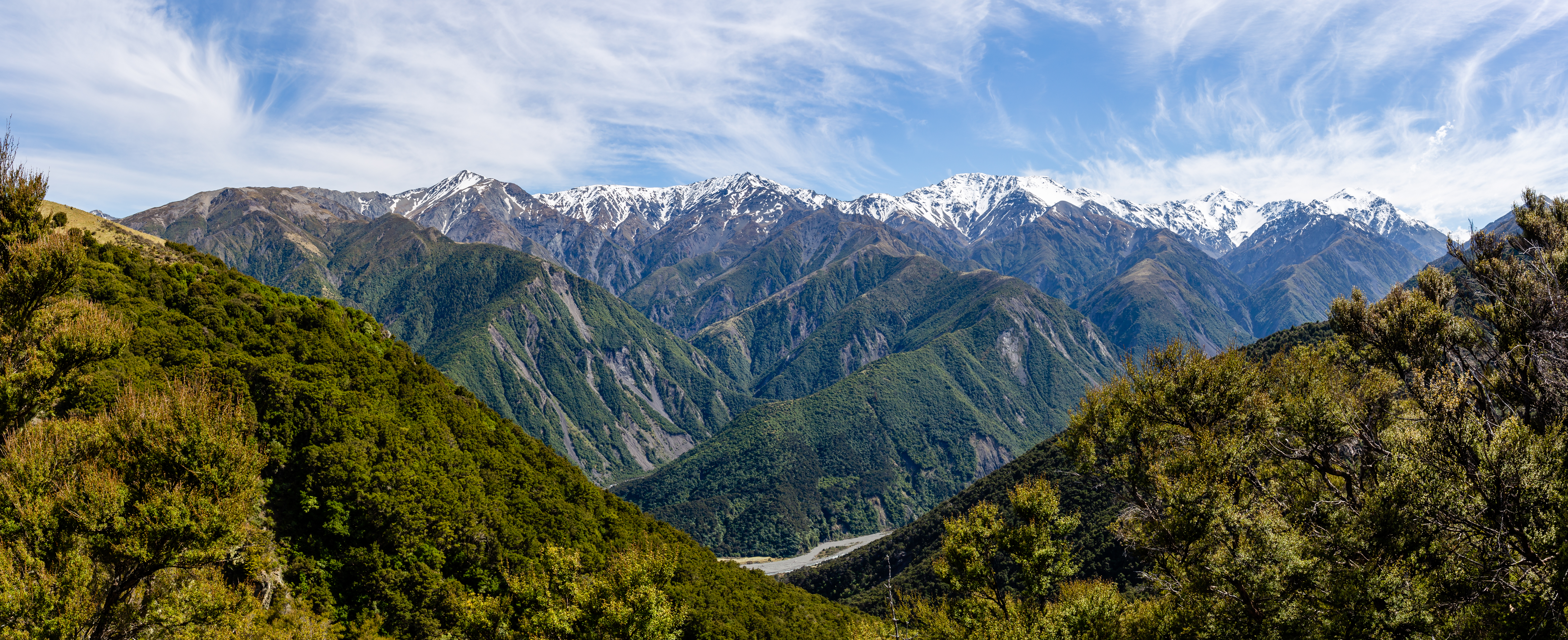
Formed along New Zealand's Marlborough Fault System, they can be seen as the northernmost extension of the Southern Alps / Kā Tiritiri o te Moana in the South Island. Named the Looker-on mountains, by Captain James Cook, they take their name from the town of Kaikōura at the southern extreme of the more eastern range, the Seaward Kaikōuras. This range rises straight from (and dominates) the coast to the north of the town, and reaches its highest point with the 2,608-metre (8,556 ft) Mount Manakau.
The long straight river valley of the Waiau Toa / Clarence River separate the Seaward Kaikōuras from the longer and loftier Inland Kaikōuras. This latter range contains the highest peak in the ranges, the 2,885-metre (9,465 ft) Tapuae-o-Uenuku, the translation from the Māori of which is the poetic "Footprint of the rainbow". Beyond the Inland Kaikōuras is the valley of the Awatere River, which runs parallel to that of the Waiau Toa / Clarence. The climate is characterised by a dry cold winter.
Demographics
The statistical area of Kaikōura Ranges includes Clarence and covers 2,037.54 km2 (786.70 sq mi).[1] It had an estimated population of 1,840 as of June 2021,[2] with a population density of 0.9 people per km2.
| Year | Pop. | ±% p.a. |
|---|---|---|
| 2006 | 1,419 | — |
| 2013 | 1,545 | +1.22% |
| 2018 | 1,689 | +1.80% |
| Source: [3] | ||
Kaikōura Ranges had a population of 1,689 at the 2018 New Zealand census, an increase of 144 people (9.3%) since the 2013 census, and an increase of 270 people (19.0%) since the 2006 census. There were 585 households. There were 894 males and 795 females, giving a sex ratio of 1.12 males per female. The median age was 44.6 years (compared with 37.4 years nationally), with 315 people (18.7%) aged under 15 years, 246 (14.6%) aged 15 to 29, 870 (51.5%) aged 30 to 64, and 261 (15.5%) aged 65 or older.
Ethnicities were 89.5% European/Pākehā, 17.1% Māori, 0.7% Pacific peoples, 3.0% Asian, and 2.3% other ethnicities (totals add to more than 100% since people could identify with multiple ethnicities).
The proportion of people born overseas was 12.4%, compared with 27.1% nationally.
Although some people objected to giving their religion, 51.3% had no religion, 36.6% were Christian, 0.4% were Hindu, 0.9% were Muslim, 0.5% were Buddhist and 2.5% had other religions.
Of those at least 15 years old, 186 (13.5%) people had a bachelor or higher degree, and 291 (21.2%) people had no formal qualifications. The median income was $35,600, compared with $31,800 nationally. The employment status of those at least 15 was that 834 (60.7%) people were employed full-time, 246 (17.9%) were part-time, and 15 (1.1%) were unemployed.[3]
Flora
These mountains are characterised by tussock land, fellfields, and large areas of open scree, while lowland forests have largely been cleared. The Spencer range to the south meanwhile has a more intact beech forest covering.[4]
Fauna
The ranges contain the Kowhai Valley and Shearwater Stream Important Bird Area.[5]

References
- "ArcGIS Web Application". statsnz.maps.arcgis.com. Retrieved 24 August 2021.
- "Population estimate tables - NZ.Stat". Statistics New Zealand. Retrieved 22 October 2021.
- "Statistical area 1 dataset for 2018 Census". Statistics New Zealand. March 2020. Kaikōura Ranges (308800). 2018 Census place summary: Kaikōura Ranges
- "Northern part of New Zealand's South Island – Ecoregions – WWF". World Wildlife Fund.
- BirdLife International. (2012). Important Bird Areas factsheet: Kowhai Valley, Shearwater Stream. Downloaded from http://www.birdlife.org on 2012-02-18.
На других языках
[de] Kaikoura Ranges
Die Kaikoura Ranges sind zwei Gebirgszüge im Nordosten der Südinsel Neuseelands, die mit zwei parallel verlaufendenen Hauptkämmen entlang der alpinen Störung in Südwest-Nordost-Richtung als nördlichste Verlängerung der Südlichen Alpen angesehen werden können. Beide Gebirgszüge haben eine Länge zwischen 80 und 90 km, gehen im Südwesten nahe dem Hanmer Forest Park in andere Gebirgszüge über, während sie im Nordosten in Richtung Cape Campbell bis zum Meeresspiegel auslaufen.- [en] Kaikōura Ranges
[ru] Каикоура (хребты)
Каикоура (англ. Kaikōura Ranges) — система двух параллельных горных хребтов, расположенная на северо-восточной оконечности Южного острова Новой Зеландии. Оба хребта видны с большого расстояния, в том числе с южного берега Северного острова[1].Другой контент может иметь иную лицензию. Перед использованием материалов сайта WikiSort.org внимательно изучите правила лицензирования конкретных элементов наполнения сайта.
WikiSort.org - проект по пересортировке и дополнению контента Википедии