geo.wikisort.org - Mountains
Jebel Aqra, properly Jebel al-ʾAqraʿ (Arabic: جبل الأقرع, [ˈd͡ʒæbæl al ˈʔaqraʕ]; Turkish: Cebel-i Akra), also known as Mount Casius, is a limestone mountain located on the Syrian–Turkish border near the mouth of the Orontes River on the Mediterranean Sea. Its Turkish side is also known as Mount Bald (Kel Dağı). Rising from a narrow coastal plain, Jebel Aqra is a mariners' landmark which gathers thunderstorms.
| Jebel Aqra | |
|---|---|
| جبل الأقرع | |
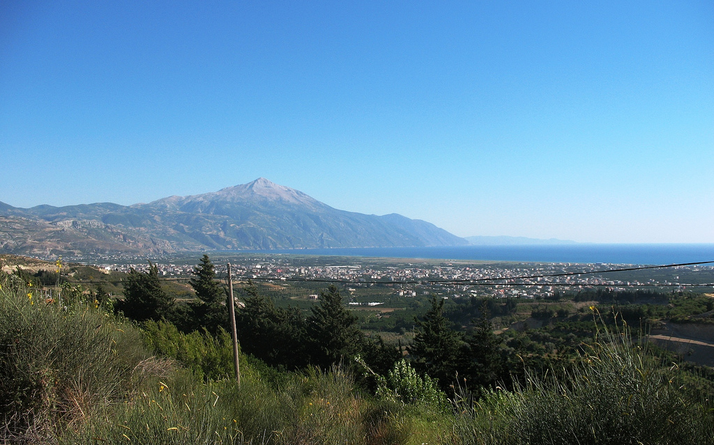
 Jebel Aqra overlooking the town of Kessab | |
| Highest point | |
| Elevation | 1,717 m (5,633 ft) |
| Coordinates | 35°57′9″N 35°58′9.5″E |
| Geography | |
 Jebel Aqra Syrian-Turkish border | |
| Location | Latakia Governorate, Kesab, Syria Hatay Province, Turkey |
The mountain was a cult site in ancient Canaanite religion and continuing through classical antiquity. A mound of ash and debris remains; an archaeological investigation was broken off because of military restrictions imposed due to the mountain's border location.
History
Jebel Aqra has a long history as a sacred mountain.[1][2]
The Hurrians called it Mount Hazzi and considered it the home of their storm god Teshub.[3] The Hittites continued his worship, celebrating Teshub's victory over the sea in the Song of Kumarbi found in their capital Hattusa.[5] They also celebrated the mountain in its own right, naming it as a divine guarantor on their treaties and observing rites in its honor.[6]
The ancient port of Ugarit (modern Ras Shamra) lies 30 kilometers (19 mi) to its south. Texts discovered there in the 1920s, including the Baal Cycle, showed its residents considered the peak of Mount Sapan (Akkadian, Ugaritic, & Phoenician: Ṣapānu) to house the lapis and silver palace of their storm god Baʿal (lit. "The Lord") and his sister ʿAnat.[7] Baʿal is now often identified with Hadad and his variations understood as local cults. The form Baʿal Zephon was worshipped widely: his temple at Ugarit held a sandstone relief dedicated to him by a royal scribe in Egypt and the king of Tyre called on him as a divine witness on a treaty with the emperor of Assyria in 677 BCE.[8]
It appears in the Hebrew Scriptures as Mount Zaphon (Hebrew: צפון Tsāfōn).[6][n 1] In ancient Canaanite religion, Mount Sapan was sometimes accounted as the home of all the gods, not only Baʿal and his sister. As Mount Zaphon, it appears in that role in the Hebrew Scriptures' Book of Isaiah, along with the Mount of the Congregation.[12] From its importance and its position at the northern end of Canaan, it also became a metonym[13][14][15] and then the word for the direction "north" in the Hebrew language.
Under various forms, worship continued through antiquity, when it was called Mount Casius (Greek: Κασιος, Kasios; Latin: Casius Mons; Armenian: Կասիոս Լեռ, Gassios Ler) and lay 10 kilometers (6.2 mi) north of Posideium (modern Ras al-Bassit). Even closer, the earliest Hellenic foothold in the Levant lies at the beach on its northern flank at Al Mina. Here Euboeans and Cypriotes experienced some of their earliest on-site experience of northwest Semitic cultures, from the early eighth century BCE onwards. "The Hittite name persisted in neo-Hittite culture into the ninth century [BCE] and so when Greeks settled on the north side of Mount Hazzi they continued to call its main peak 'Mount Kasios'", Lane Fox points out, observing that it was the Mount Olympus of the Near East.[16]
The cult of the god of the mountain was transferred, by interpretatio graeca, to Zeus Kasios, the "Zeus of Mount Kasios", similar to Ras Kouroun in the Sinai. Tiles from the Greco-Roman sanctuary at the site, stamped with the god's name, were reused in the Christian monastery that came to occupy the eastern, landward slopes of Kazios.[17]

When kings and emperors climbed Mount Kasios to sacrifice at its peak sanctuary, it was a notable cultural occasion. Seleucus I Nicator sought there the advice of Zeus in locating his foundation, a Seleuceia (one of many) on the coast. Coins struck there as late as the first century BCE still show the city's emblem, the thunderbolt, sometimes placed upon the cushion of a throne. In the winter of 114/15 CE Trajan was spared in a major earthquake that struck Antioch; commemorative coins were struck featuring the shrine of Zeus Kasios, with its pointed roof on pillars, and a representation of its rounded sacred stone, or betyl.[18] Trajan's adoptive son Hadrian accompanied him; he returned in 130 AD to scale the mountain at night, no doubt, Lane Fox remarks, to witness the rising of the sun, visible for several minutes from the peak, while the land below lay still in darkness; it was said later that a thunderbolt at the peak struck the animal he was about to sacrifice. In spring 363 the last pagan emperor, Julian, scaled the mountain, where he had an epiphanic vision of Zeus Kasios, according to his friend and correspondent Libanius.[citation needed]
Greek theophoric names Kassiodora and Kassiodorus,[19] equally a "gift of Kasios", recall a vow of one or both parents made to ensure fertile conception.[20]
Christian hermits were drawn to the mountain; Barlaam challenged its demons by founding a monastery near the treeline on its eastern slopes, and Simeon Stylites the Younger stood for forty years on a pillar near its northern flanks until his death in 592.
The cult site is represented by a huge mound of ashes and debris, 180 feet (55 m) wide and 26 feet (7.9 m) deep, of which only the first 6 feet (1.8 m) have been excavated. Archaeologists only reached as far as the Hellenistic strata before the site was closed, as it lies in a Turkish military zone on its border with Syria.[3]
Notes
References
Citations
- DDD (1999).
- Lane Fox (2000).
- Lane Fox (2009), p. 245.
- Rutherford (2001).
- Lane Fox,[3] quoting Rutherford.[4]
- DDD (1999), p. 927.
- Lane Fox (2009), p. 244.
- Lane Fox (2009), p. 252.
- Bar Daroma (1958), p. 180–199.
- Num. 34:7–8.
- Hertz (1988).
- Isa. 14:13.
- Gen. 13:14.
- Deut. 3:27.
- Ps. 48.
- Lane Fox 2009:246; these cultural connections are the theme of Lane Fox's book.
- Lane Fox 2009:246, noting H. Seyrig in W. Djobadze, Archaeological Investigations in the Region West of Antioch and the Orontes, 1986.
- Lane Fox 2009:248f.
- See Cassiodorus, born in Magna Graecia, who bears the name in its Romanized form.
- Lane Fox 2009:248, notes also Kassi-opeia, whose daughter Andromeda was exposed to a sea-monster further along the coast, at Joppa.
Bibliography
- "Zaphon", Dictionary of Deities and Demons in the Bible, 2nd ed., Grand Rapids: Wm. B. Eerdmans Publishing, 1999, pp. 927–928.
- Bar Daroma, Chaim (1958), זה גבול הארץ; גבולותיה האמתיים של ארץ ישראל לאור המקורות [Ve-zeh Gevul Ha-arets: Gevuloteha ha-Amitiyum Shel Erets Yisra'el le-'or ha-Mekorot; And This Shall Be the Border of the Land: The True Boundaries of Israel According to the Sources], Jerusalem: Hotsa'at Sefarim Be'er le-Heker ha-Mikra Veha-arets. (in Hebrew)
- Hertz, Joseph H., ed. (1988), The Pentateuch and Haftorahs, Soncino Press.
- Lane Fox, Robin (2009), "A Travelling Mountain", Travelling Heroes in the Epic Age of Homer, New York: Knopf, pp. 243–258.
- Rutherford, Ian (2001), "The Song of the Sea", Studien zu den Boghaz-Köy-Texten, No. 45, pp. 598–609.
На других языках
[de] Keldağ
Der Keldağ, Kel Dağı, (deutsch: ‚Kahler Berg‘) auch Kılıç Dağı (deutsch: ‚Schwertberg‘), arabisch Dschabal al-Aqra (arabisch جبل الأقرع, DMG Ǧabal al-Aqraʿ ‚Kahler Berg‘; auch Jabal al-Aqra oder Jebel al-Akra transkribiert; auch Cebeli akra) oder Kasios-Berg (armenisch Կասիոս լեռը .mw-parser-output .Latn{font-family:"Akzidenz Grotesk","Arial","Avant Garde Gothic","Calibri","Futura","Geneva","Gill Sans","Helvetica","Lucida Grande","Lucida Sans Unicode","Lucida Grande","Stone Sans","Tahoma","Trebuchet","Univers","Verdana"}Kasios ler'y'; altgriechisch Κάσιον ὂρος Kásion óros, lateinisch Casius Mons) ist ein Berg an der Grenze zwischen Syrien und der Türkei, nahe der Mündung des Orontes ins Mittelmeer und etwa 40 Kilometer nördlich der bronzezeitlichen Stadt Ugarit und 65 km südwestlich des modernen Antakya. Der 1736 Meter[1] hohe Berg liegt nahe an der Küste und dient der Seefahrt als Orientierungspunkt. Administrativ gesehen liegt der syrische Teil des Berges auf dem Gebiet der armenisch geprägten Kleinstadt Kessab im Gouvernement Latakia, der türkische Teil im Landkreis Yayladağı der Provinz Hatay.- [en] Jebel Aqra
[fr] Djebel Akra
Le djebel Akra, en arabe جبل الأقرع, en turc Cebel-i Akra ou Kel Dağı, est un sommet situé en Turquie près de la frontière avec la Syrie.[it] Jebel Aqra
Il Jebel Aqra (arabo: جبل الأقرع;Turco: Cebel-i Akra), noto anche come Monte Casius[1], è una montagna alta 1.717 m (5.633 piedi) calcarea situata sul confine tra la Siria e la Turchia in territorio turco vicino alla foce del fiume Oronte sul Mar Mediterraneo. Il suo lato turco è anche conosciuto come Monte Calvo (Kel Dağı). La montagna era un luogo di culto nell'antica religione cananea.[2][ru] Джебели-Акра
Джебели-Акра[1] (араб. الجبل الأقرع, тур. Kel Dağı) — гора, расположенная на сирийско-турецкой границе недалеко от устья реки Аси (Оронт) в иле Хатай в районе Яйладагы (Турция) и Латакии (Сирия).Другой контент может иметь иную лицензию. Перед использованием материалов сайта WikiSort.org внимательно изучите правила лицензирования конкретных элементов наполнения сайта.
WikiSort.org - проект по пересортировке и дополнению контента Википедии