geo.wikisort.org - Mountains
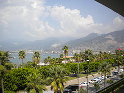
The Nur Mountains (Turkish: Nur Dağları, "Mountains of Holy Light"), formerly known as Alma-Dağ,[1] the ancient Amanus (Ancient Greek: Ἁμανός), medieval Black Mountain, or Jabal al-Lukkam in Arabic,[2] is a mountain range in the Hatay Province of south-central Turkey, which starts south of the Taurus Mountains (and is linked with it), south of the Ceyhan river (old name: Pyramus), runs roughly parallel to the Gulf of İskenderun (old name: Gulf of Issus) (İskenderun was called Alexandria of Cilicia) and ends in the Mediterranean coast between the Gulf of İskenderun and the Orontes (Asi) river mouth.
| Nur Mountains | |
|---|---|
| Alma-Dağ | |
| Highest point | |
| Elevation | Bozdağ Dağı |
| Naming | |
| Native name | Nur Dağları (Turkish) |
| Geography | |
| Country | Turkey |
| Province | Hatay |


The range has about 100 miles (200 kilometers) in length and reaches a maximum elevation of 2,240 m (7,350 ft) and divides the coastal region of Cilicia from Antioch and inland Syria making a natural border between Asia Minor (Anatolia), in the southeast region, and the rest of Southwest Asia. The highest peak is Bozdağ Dağı. A major pass through the mountains known as the Belen Pass (Syrian Gates) is located near the town of Belen. Another pass known as the Amanic Gates (Bahçe Pass) lies farther north.
The specific term "Mount Amanus" is referred to by ancient writers.[3][4] In the Middle Ages, it was called the Black Mountain in Byzantine Greek, Armenian, Syriac and Latin. There were numerous Armenian, Melkite, Jacobite, Georgian, and Catholic monasteries and hermits in the mountains. On account of this, it was called Gâvur Dağ (Mount of Infidels) by the Turks. In 1028, the Emperor Romanos III, disturbed by the number of "heretical" (i.e., Syriac and Armenian) monks in the Black Mountain, tried to draft them for his campaign against Aleppo. In 1066, the monasteries were devastated by Afshin Bey. In 1098, the monks gave provisions to the Crusader army besieging Antioch.[5]
See also
- Nikon of the Black Mountain
References
- Merriam-Webster's Geographical Dictionary, Third Edition. Springfield, MA: Merriam-Webster. 1997. p. 855. ISBN 9780877795469. Retrieved 19 January 2017.
- Mohsen Zakeri, Sasanid Soldiers in Early Muslim Society: The Origins of 'Ayyārān and Futuwwa (Otto Harrassowitz Verlag, 1995), p. 151.
- Grote, George (1862). A History of Greece. London: John Murray. p. 312. Retrieved 19 January 2017.
Mount Amanus.
- Anthon, Charles (1872). A Classical Dictionary. New York: Harper & Brothers. Retrieved 19 January 2017.
- Jos J. S. Weitenberg, "The Armenian Monasteries in the Black Mountain", in K. Ciggaar and M. Metcalf (eds.), East and West in the Medieval Eastern Mediterranean, Vol. 1 (Peeters, 2006), pp. 79–81.
На других языках
[de] Nurgebirge
Das Nurgebirge (tr.: Nur Dağları) auch Amanosgebirge (tr.: Amanos Dağları) oder Gavurgebirge (tr.: Gâvur Dağları, dt.: Gebirge der Ungläubigen) genannt, ist ein Gebirge östlich des Golfs von İskenderun. Die Amanos Dağları zweigen am Ostende des Taurusgebirges von diesem ab und verlaufen in südsüdwestliche Richtung. Der Gebirgszug erstreckt sich an der Mittelmeerküste entlang bis hin zum Libanon. Der Ost- und Westhang besteht aus einem Kern von paläozoischen Schiefern und einem Mantel aus kretazischen Kalken. An diesem Teil des Bergzuges findet man weit verstreute Reste von Eisenerz-Bergwerken. Im Jahr 19 n. Chr. wurde laut der Tabula Siarensis ein Pass des Gebirges als Standort für einen Ehrenbogen für den verstorbenen römischen Feldherren Germanicus vorgesehen.- [en] Nur Mountains
[es] Amanus
Montañas Nur (en turco, Nur Dağları)[lower-alpha 1] —también llamadas «[el] Amanus» en fuentes en castellano—[2][lower-alpha 2] es el nombre dado a una cadena montañosa situada en el sur de la actual Turquía. El pico más alto[7] es el Mıgır Tepe, o «Bozdağ», con una altura de 2240 m.[8][fr] Monts Nur
Les monts Nur, en turc Nur Dağları, littéralement en français « monts de la lumière », anciennement monts Amanus ou Amanos, en turc Elma Dağ, sont une chaîne de montagnes du Sud-Est de la Turquie.[it] Monti Nur
I Monti Nur (turco: Nur Dağları), (o Montagne della luce sacra), anticamente detti monti Amanus, sono una catena montuosa della Turchia meridionale, al confine con la Siria. Essi sono spesso considerati come la propaggine meridionale della catena del Tauro Orientale esterno. L'altezza massima di 2240 m viene raggiunta dal monte Bozdağ.[ru] Нур (хребет)
Нур или Ама́нос, Ама́н (др.-греч. Ἁμανός, лат. Amanus, тур. Nur Dağları — горы Святого Света, Gâvur Dağları — горы неверных [имеются в виду армяне с точки зрения мусульман], Amanos Dağları) — горный хребет, идущий практически параллельно заливу Искендерун. В Средние века служил границей Сирии и Киликийской Армении (ныне это — часть южной Турции).Другой контент может иметь иную лицензию. Перед использованием материалов сайта WikiSort.org внимательно изучите правила лицензирования конкретных элементов наполнения сайта.
WikiSort.org - проект по пересортировке и дополнению контента Википедии
