geo.wikisort.org - Mountains
Guadalupe Hill is a 3,360-metre (11,020 ft) high hill located in the Eastern Hills, uphill from the centre of Bogotá, Colombia. Together with its neighbouring hill Monserrate it is one of the landmarks of Bogotá. At the top of the hill a hermitage and a 15-metre (49 ft) high statue has been erected. The statue was elaborated by sculptor Gustavo Arcila Uribe in 1946 and is accompanied by a chapel dedicated to Our Lady of Guadalupe.
| Guadalupe Hill | |
|---|---|
 Guadalupe Hill seen from Monserrate | |
| Highest point | |
| Elevation | 3,360 m (11,020 ft)[1] |
| Coordinates | 4°35′31″N 74°03′15″W |
| Naming | |
| Native name | Cerro de Guadalupe (Spanish) |
| Geography | |
 Guadalupe Hill | |
| City | Bogotá, Colombia |
| Parent range |
|
| Geology | |
| Age of rock | Guadalupe Group (type locality) Campanian-Maastrichtian |
| Mountain type | Thrusted mountain |
| Climbing | |
| First ascent | Pre-Columbian era |
| Easiest route | Pilgrimage trail Avenida Circunvalar→Road to Choachí |
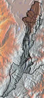
Guadalupe Hill is the type locality of the Guadalupe Group, a Late Cretaceous sedimentary sequence of sandstones and shales of 750 metres (2,460 ft) thick. The formation is being thrust on top of younger strata by the reverse Bogotá Fault as a result of the ongoing Andean orogeny. The hill is the source for the Manzanares and El Chuscal creeks that flow westwards onto the Bogotá savanna.
Historically, Guadalupe Hill was an important sacred site for the indigenous Muisca, who inhabited the Bogotá savanna and surrounding regions before the Spanish conquest. During the colonial period, Guadalupe Hill contained a cross and the hermitage that was destroyed by various earthquakes in the eighteenth, nineteenth and twentieth centuries. On Sundays, Guadalupe Hill and its chapel and statue are visited by tourists and pilgrims from Bogotá, accessing the hill either by road and public transport or via a walking trail to the hilltop.
Etymology
Guadalupe Hill is named after Our Lady of Guadalupe of Badajoz, not -as is commonly believed- after the famous Our Lady of Guadalupe in Mexico.[2]
Geology
The Guadalupe Hill is the type locality for the Campanian-Maastrichtian Guadalupe Group, a sequence of three formations of sandstones and shales; Arenisca Dura, Plaeners, Arenisca de Labor and Arenisca Tierna. The thickness of the Guadalupe Group, defined as formation by some authors, at Guadalupe Hill is 750 metres (2,460 ft).[3] Approximately 53% of the Eastern Hills consists of the Guadalupe Group.[4]
The Guadalupe Group is thrusted on top of the younger Guaduas, Bogotá and Cacho Formations by the Bogotá Fault.[5] The NNW-SSE trending eastward dipping thrust fault forms a barrier for aquifers.[6] The creeks (quebradas) Manzanares and El Chuscal originate from Guadalupe Hill.[7]
History

Guadalupe Hill in the times before the Spanish conquest was one of the sacred hilltops in the religion of the Muisca, the indigenous inhabitants of the Bogotá savanna. They considered the hills sacred and buried their dead in the mountains. The people, organised in a loose confederation of leaders, the Muisca Confederation, had an advanced knowledge of archaeoastronomy and constructed various temples honouring Sué, the god of the Sun, throughout their territories. Guadalupe Hill in pre-Columbian times was called in their language Muysccubun quijicha guexica, "grandfather's foot".[8] Seen from Bolívar Square, at the winter solstice of December, Sué rises exactly over Guadalupe Hill and at the equinoxes of March and September in the valley between Monserrate and Guadalupe.[9]
At the time of the conquest, the Eastern Hills were a forested natural boundary of the Bogotá savanna. During the early colonial period, the Spanish constructed a cross on Guadalupe Hill as a symbol to protect the capital of the New Kingdom of Granada.[2] The wood of the trees of the Eastern Hills were used for construction and heating in the city that grew steadily until the 19th century. This led to deforestation and erosion in the Eastern Hills and when Alexander von Humboldt visited Santa Fe de Bogotá in 1806, he noted "that there was not a single tree left until the open area of Choachí".[10] The first replanting of trees took place in 1855, and a second phase of reforestation happened in 1940.[11][12] In 1801, Francisco José de Caldas recalculated the height of Guadalupe Hill.[13]
Hermitage and statue


The first hermitage on Guadalupe Hill was built in 1656 and blessed during a pilgrimage on September 8 of that year.[2] The hermitage was destroyed by the earthquakes of 1743, 1785 and 1827. During the presidency of Tomás Cipriano de Mosquera, the hermitage was reconstructed, but affected again by the 1917 Bogotá earthquake.[14] The hermitage was rebuilt in 1945 by Jorge Murcia Riaño and blessed by archbishop Ismael Perdomo. In 1946, the 15 metres (49 ft) high statue of the Virgin of Guadalupe, sculpted by Gustavo Arcila Uribe, was constructed on top of Guadalupe Hill.[2] In 1967, the chapel and road leading up to it were constructed.[2][15]
Tourism
The Guadalupe Hill and the statue of the Virgin of Guadalupe are among the main touristic attractions of Bogotá. The top of the hill offers a viewpoint (mirador) for the Colombian capital. The hill can be accessed via a walking trail, used by pilgrims since colonial times, or by the road to Choachí via the Avenida Circunvalar.[2][14]
Public transport to Guadalupe Hill leaves on Sundays from Carrera 10 with Calle 6.[15] Since 1997, a running contest is held to ascend the Guadalupe Hill.[16]
Every Sunday, the chapel on the hill receives tourists between 7:00 in the morning and 4:00 in the afternoon.[15] On the first Sundays of the month, a mass is held from 8:00 to 10:00 AM and at noon.[2]
Gallery
 Guadalupe Hill from Monserrate
 Guadalupe Hill behind the business district of Bogotá
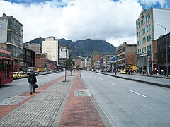 Clouds over Guadalupe Hill
from Avenida Jiménez Our Lady of Guadalupe statue
 Head of the statue


See also
- Eastern Hills, Bogotá
- Bogotá savanna
References
- Wiesner Ceballos et al., 2007, p.33
- (in Spanish) Cerro de Guadalupe, una joya bogotana que no puede dejar de visitar
- Guerrero Uscátegui, 1992, pp.4–5
- Wiesner Ceballos et al., 2007, p.16
- Geological Map Bogotá, 1997
- Velandia & De Bermoudes, 2002, p.42
- Wiesner Ceballos et al., 2007, p.32
- Bonilla Romero, 2011, p.14
- Bonilla Romero et al., 2017, p.153
- Camargo Ponce de León, s.a., p.6
- Wiesner Ceballos et al., 2007, p.17
- Wiesner Ceballos et al., 2007, p.18
- De Caldas, 1801, p.365
- (in Spanish) El Cerro de Guadalupe
- (in Spanish) Santuario de Nuestra Señora de Guadalupe Archived 2017-01-31 at the Wayback Machine
- (in Spanish) Ascenso al cerro de Guadalupe – El Espectador
Bibliography
- ; , and . 2017. Arqueoastronomía, alineaciones solares de solsticios y equinoccios en Bogotá-Bacatá – Archaeoastronomy, alignment solar from solstices and equinoxes in Bogota-Bacatá. Revista Científica, Universidad Distrital Francisco José de Caldas 27. 146–155. Accessed 2017-01-18.
- . 2011. Aproximaciones al observatorio solar de Bacatá-Bogotá-Colombia – Approaches to solar observatory Bacatá-Bogotá-Colombia. Azimut, Universidad Distrital Francisco José de Caldas 3. 9–15. Accessed 2017-01-18.
- . 1801. Observaciones sobre la verdadera altura del Cerro de Guadalupe que domina esta ciudad, dirigidas a los editores del "Correo Curioso", 365–374. Accessed 2017-01-18.
- . s.a. Historia pintoresca y las perspectivas de ordenamiento de los Cerros Orientales de Santa Fe de Bogotá, 1–16. Accessed 2017-01-18.
- . 1992. Geología e Hidrogeología de Santafé de Bogotá y su Sabana, 1–20. Sociedad Colombiana de Ingenieros.
- . 1997. Mapa geológico de Santa Fe de Bogotá – Geological Map Bogotá – escala 1:50,000, 1. Ingeominas. Accessed 2017-01-18.
- , and . 2002. Fallas longitudinales y transversales de la Sabana de Bogotá, Colombia. Boletín de Geología 24. 37–48.
- ; ; ; ; , and . 2007. Los caminos de los cerros, 1–73. Alcaldía Mayor de Bogotá. Accessed 2017-01-18.
Further reading
- . 1924. Architecture of Bogotá, _. Facsimile collection – 1988 Edition – Bogotá – ISBN 958-9054-12-9.
External links
- (in Spanish) Shrine of Our Lady of Guadalupe
- (in Spanish) Seismic history of Bogotá
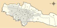
 | Administrative subdivision in 20 localities |
|  |
|---|---|---|---|
| Metropolitan Area | |||
| Geography |
| ||
| |||
На других языках
- [en] Guadalupe Hill
[es] Cerro de Guadalupe
El cerro de Guadalupe es uno de los más notables cerros orientales de Bogotá. Junto a Monserrate se le conoce como uno de los cerros tutelares de la ciudad, ubicados entre la ciudad y el páramo de Cruz Verde.[fr] Cerro de Guadalupe
Le cerro de Guadalupe (français : colline de Guadalupe), situé dans la cordillère Orientale (Andes), est l'un des plus remarquables cerros orientales environnant Bogota, la capitale de la Colombie. Tout comme le cerro de Monserrate, il semble protéger la ville. Ces deux cerros bordent, à l'est, la savane de Bogota.Другой контент может иметь иную лицензию. Перед использованием материалов сайта WikiSort.org внимательно изучите правила лицензирования конкретных элементов наполнения сайта.
WikiSort.org - проект по пересортировке и дополнению контента Википедии