geo.wikisort.org - Mountains
The Cuillin (Scottish Gaelic: An Cuiltheann)[2] is a range of mostly jagged rocky mountains on the Isle of Skye in Scotland. The main Cuillin ridge is also called the Black Cuillin[3] to distinguish it from the Red Cuillin (na Beanntan Dearga), which lie to the east of Glen Sligachan.[4]
| Cuillin Hills National Scenic Area | |
|---|---|
 | |
 The location of the Cuillin within Highland (map centred on Sgùrr Alasdair) | |
| Location | Isle of Skye, Highland, Scotland |
| Coordinates | 57.20°N 6.2°W |
| Area | 227 km2 (88 sq mi)[1] |
| Established | 1981 |
| Governing body | NatureScot |
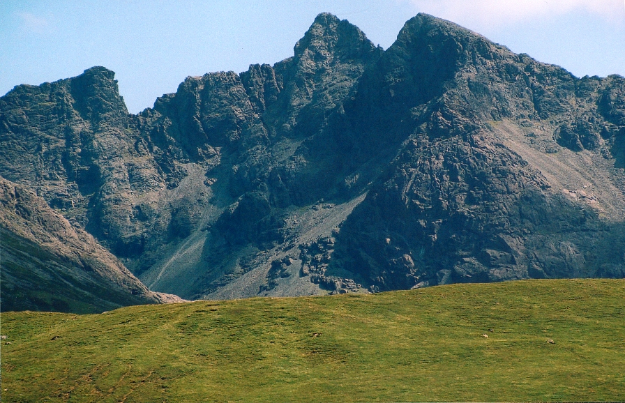
The peaks of the Black Cuillin are mainly composed of gabbro, a very rough igneous rock which provides a superb grip for mountaineers; and basalt, which can be very slippery when wet.[3] The rocks forming the ridge of the Black Cuillin (and outliers such Blà Bheinn) are dark, particularly in the shade, but when in sunlight the Black Cuillin can appear grey to brown.[5] The main ridge forms a narrow crest, with steep cliffs and scree slopes.[6] The ridge is about 14 km long (from Gars-bheinn in the south to Sgùrr nan Gillean in the northeast), and curves in an irregular semi-circle around Loch Coruisk, which lies at the heart of the range.[7][6] The highest point of the Cuillin, and of the Isle of Skye, is Sgùrr Alasdair in the Black Cuillin at 992 m (3,255 ft).[3]
The Red Cuillin are mainly composed of granite, which is paler than the gabbro (with a reddish tinge from some angles in some lights) and has weathered into more rounded hills with vegetation cover to summit level and long scree slopes on their flanks. These hills are lower and, being less rocky, have fewer scrambles or climbs.[5] The highest point of the red hills is Glamaig (775 m), one of only two Corbetts on Skye (the other being Garbh-bheinn, part of the small group of gabbro outliers surrounding Blà Bheinn).[8]
The scenic beauty of the Cuillin has led to it being designated a national scenic area,[9] one of forty such areas in Scotland.[10] A Scottish Natural Heritage review of the special qualities of the Cuillin stated:
The mountains rise up dramatically from the sea creating formidable, enclosed sea lochs, with the absence of foothills enhancing their vast scale. Many iconic views of Scotland are centred here, whether Sgurr nan Gillean soaring above Sligachan, Loch Scavaig and the Cuillin ridge from Elgol, or Bla Bheinn above Torrin.
— Scottish Natural Heritage[5]
Etymology

There are several theories about the derivation of the name Cuillin. One suggestion is that it comes from the Old Norse word kjölen, which literally means the keel of a boat,[11] suggesting a similarity with an upturned Viking longship. Peter Drummond, in Scottish Hill and Mountain Names (1991), noted this is also a name of the Scandinavian Mountains and says it can mean 'high rocky mountain'.[12] Another suggestion is that it comes from Gaelic cuilionn, meaning 'holly', because of the mountains' jagged shape.[12] The name has also been linked to Gaelic mythology, with the hills being the place where Cúchullin learnt archery from the female warrior Scáthach.[5] It is also suggested it may come from a word meaning "worthless" (in an agricultural or economic sense), given their lack of vegetation.[13]
Natural history
The Cuillin are a diverse and complex geological landscape, and there is a clear distinction visible between the two mountain types.[5] The mountains formed from the remains of the magma chambers which fed volcanic eruptions.[14] In the Black Cuillin the rocks cooled to form gabbro, the coarse-grained rock that makes up much of the range. Cracks and fissures in the rock provided pathways for later magma intrusions, leading to dykes of basalt which are commonly seen across Skye.[14] The Red Cuillin also have volcanic origins, being formed from a later intrusion of acidic, granitic rock.[5] This granite was more uniformly eroded by wind and water than the gabbro and basalt, causing the red hills to have smoother outlines.[14]
The Cuillin provide classic examples of glacial topography and were the subject of an early published account by James Forbes in 1846 (who had become a fellow of the Royal Society of Edinburgh aged only nineteen).[15][16] He partnered Louis Agassiz on his trip to Scotland in 1840 and although they subsequently argued, Forbes went on to publish other important papers on Alpine glaciers.[17] In 1904 Alfred Harker published The Tertiary Igneous Rocks of Skye, the first detailed scientific study of an extinct volcano.[18][19]
The Cuillin encompasses a wide range of habitats, changing with altitude. At the base there are conifer plantations, coastal woodlands and areas of heather moorland and rough grassland. The lower slopes are covered by various different types of bog, with grassland on the better-drained slopes that are found above 400 m. Higher up, the rocky hills are largely bare, with exposed rock and scree.[6] The entire area is designated as a Special Protection Area under the Natura 2000 programme due particularly for its importance to golden eagles. The site is of European importance for these birds, and holds one of the highest-density populations in Britain, having an unusually high breeding productivity.[6] 11 pairs were estimated in 1992, this representing about 3% of the breeding population in Great Britain at that time.[6]
The Cuillin are protected as a national scenic area, defined so as to identify areas of exceptional scenery and to ensure its protection from inappropriate development.[10] The areas protected by the designation are considered to represent the type of scenic beauty "popularly associated with Scotland and for which it is renowned".[20] The Cuillin Hills National Scenic Area covers 27,320 ha, of which 22,726 ha is on land, with a further 4594 ha being marine (i.e. below low tide level).[1]
History

Due to the rocky nature of the Cuillin they have historically been of little use for agriculture: this contrasts with the majority of the highlands, where the hills were used to provide seasonal grazing for cattle and sheep. Despite the lack of earlier human presence in the hills themselves, there is much evidence of historic settlement in the surrounding glens, with prehistoric hut circles found in Glenbrittle,[21] and a stone circle identified in Glen Sligachan.[22] Rubha an Dùnain, an uninhabited peninsula to the south of the main ridge, has a variety of archaeological sites dating from the Neolithic onwards. There is a 2nd or 3rd millennium BC chambered cairn, an Iron Age promontory fort and the remains of another prehistoric settlement dating from the Bronze Age nearby. Loch na h-Airde on the peninsula is linked to the sea by an artificial "Viking" canal that may date from the later period of Norse settlement.[23][24]
The Norse held sway throughout the Hebrides from the 9th century until after the Treaty of Perth in 1266. In the post–Norse period the most powerful clans on Skye were Clan MacLeod, originally based in Trotternish, and Clan Macdonald of Sleat. Following the disintegration of the Lordship of the Isles, the Mackinnons also emerged as an independent clan, whose substantial landholdings in Skye were centred on Strathaird.[25] The MacDonalds and the MacLeods were bitter rivals, and two major battles of this period were fought between the clans at Harta Corrie and Coire Na Creich in the Cuillin:
- In 1395 a force of MacDonald clansmen landed at Loch Eynort, and headed north along Glen Sligachan, intending to invade MacLeod land.[26] They were met by a force of MacLeods at Harta Corrie, below Sgùrr nan Gillean at the head of Glen Sligachan.[27] The battle was a victory for the MacDonalds, who "fought the entire day till not one Macleod was left, and the bodies of the slain were piled round the base of a huge rock, topped by a Rowan tree and still called the 'Bloody Stone'" according to MEM Donaldson.[28]
- The Battle of Coire Na Creiche, the last Scottish clan battle fought on Skye, was fought on the slopes below Bruach na Frìthe, near the head of Glenbrittle in 1601. The MacDonalds of Sleat defeated the MacLeods after a bitter feud.[29]
Boswell and Johnson visited Skye during their tour of the Western Isles in 1773, and observed snow falling on the summits of the range in September.[30] Boswell described the Cuillin as "a prodigious range of mountains, capped with rocks like pinnacles in a strange variety of shapes".[30]
Uniquely for a group of Scottish mountains there are no records of the majority of the Cuillin summits having been climbed prior to the start of mountaineering as a leisure activity in the Victorian era,[31] a situation reflected in the fact that around half the summits had no recorded name prior to this period, although names for corries and other features were in existence.[13] Many of the summits are thus named after early climbers such as John MacKenzie (Sgùrr MhicChoinnich), Alexander Nicolson (Sgùrr Alasdair), and Norman Collie (Sgùrr Thormaid).[3]
Ownership
The Cuillin now consists of two estates divided by Glen Sligachan.[32] The hills on the west side of Glen Sligachan (the Black Cuillin) remained the property of Clan MacLeod despite the long history of conflict between them and Clan MacDonald. The earliest formal record of MacLeod ownership was in a land grant from the Crown in 1611.[33] In 2000 the Cuillin were put on sale for £10 million by the clan chief, John MacLeod of MacLeod, in a scheme of land in exchange for repairs to Dunvegan Castle,[34] however there was a dispute over ownership, as opponents of the sale argued that the charter referred to the MacLeod's Tables which stand across the loch from Dunvegan Castle and not to the Cuillin themselves. A deal was cut for the property to be gifted in return for repairs to the clan castle,[34] although it later fell through, with opponents arguing that the cost was out of proportion compared to other equivalent land sales.[33] Following the death of John MacLeod in 2007 his successor, Hugh Magnus MacLeod of MacLeod, found alternative funding sources, and as of 2017 ownership of the main range remains in the MacLeod family.[33]
The Strathaird, Torrin and Sconser Estate lies on the eastern side of Glen Sligachan, encompassing the Red Cuillin and Bla Bheinn: it is owned by the John Muir Trust,[35] a charity that seeks to protect and enhance wild places.[36] Strathaird Estate was formerly owned by musician Ian Anderson, the frontman for Jethro Tull, who sold the estate to the trust in 1994, for around £750,000.[37]
Climbing and hillwalking

The summits of the Cuillin are bare rock, jagged in outline and with steep cliffs and deep cut corries and gullies. Twelve Black Cuillin peaks are listed as Munros, though one of them, Blaven, is part of a group of outliers separated from the main ridge by Glen Sligachan.[3]
The scrambler can access most of the individual peaks by their easiest routes. Only the Inaccessible Pinnacle is a graded rock climb (Moderate) by its simplest line but several of the other summits require scrambling skills. Navigation on the ridge is difficult due to jagged terrain and magnetic abnormalities that make compass reading unreliable.[3] The majority of scramblers heading on to the Black Cuillin do so via routes from Glenbrittle (where there is a campsite and a youth hostel) or Sligachan for the northern peaks: due to the remoteness of Loch Coruisk, which can only be reached by boat or a c. 10 km walk from Elgol, routes starting from this side are less frequented.[3]

In addition to climbing individual peaks, there is the challenge of a full traverse of the main Black Cuillin ridge. Although only 11 kilometres (7 mi) in length, the average traverse is likely to take 15–20 hours from sea level at Glenbrittle to the bar of the Sligachan Hotel owing to the difficulty of the terrain and route-finding problems. The first recorded traverse in under 24 hours was on 10 June 1911 by Leslie Shadbolt and Alastair C. McLaren, in 12 hours 18 minutes top to top[38] (16.75 hours in total[39]). The record for the full traverse, set by Finlay Wild in October 2013, stands at 2 hours, 59 minutes and 22 seconds[40] (though this time is from Gars-bheinn to Sgùrr nan Gillean and does not include the initial ascent from Glenbrittle or the final descent to Sligachan).[41] A further issue for those attempting the full traverse is the fact that there are no natural sources of water on the ridge (except for winter snows and melt water), although there are a few high burns just off the main ridge from which water can be obtained.[42]
Some believe the ultimate mountaineering experience of the UK is the full traverse of the Cuillin Ridge, especially under winter conditions.[43][44] The Isle of Skye's position in the warm Gulf Stream makes genuine winter conditions rare, and the very short winter days probably make a 24-hour traverse impractical. The first recorded, over two days, was in 1965 by D. Crabbe, B. Robertson, T. Patey and H. MacInnes.[citation needed]
A longer challenge, known as the "Greater Traverse" includes all the Skye Munros, though omitting some gabbro outliers: this involves continuing on to Clach Glas and Blaven. This traverse was first done independently by two parties, in the summer of 1939, with I. Charleson and W. Forde claiming precedence over W. H. Murray & R. G. Donaldon a few weeks later (see W. H. Murray's book for details of his traverse).[citation needed]
List of summits
The list below shows all the Munros, Corbetts and Grahams of the Cuillin. It, therefore, excludes peaks such as Clach Glas, which do not meet the criteria for these hill listings.
| Summit | Range | Classification | Absolute height (m) | Relative height (m) | Grade of easiest route | Easiest route(s) |
|---|---|---|---|---|---|---|
| Sgùrr nan Gillean | Black Cuillin | Munro | 964 | c. 204 | Grade 3 scramble | South-east ridge[3] |
| Am Basteir | Black Cuillin | Munro | 934 | c. 55 | Grade 2 scramble | East ridge avoiding the "Broken Step" on the left[3] |
| Bruach na Frìthe | Black Cuillin | Munro | 958 | c. 125 | Walk | Ascent via Fionn Choire[3] |
| Sgùrr a' Mhadaidh | Black Cuillin | Munro | 918 | c. 71 | Grade 2/3 scramble | North-west or south ridges[3] |
| Sgùrr a' Ghreadaidh | Black Cuillin | Munro | 973 | c. 123 | Grade 3 scramble | North ridge[3] |
| Sgùrr na Banachdaich | Black Cuillin | Munro | 965 | c. 114 | Walk | Ascent via Coire nan Eich[3] |
| Inaccessible Pinnacle (Sgùrr Dearg) | Black Cuillin | Munro | 986 | 182 | Moderate rock climb | East ridge of Inaccessible Pinnacle[3] |
| Sgùrr MhicChoinnich | Black Cuillin | Munro | 948 | c. 56 | Grade 2 scramble | North ridge[3] |
| Sgùrr Alasdair | Black Cuillin | Munro | 992 | 992 | Grade 2 scramble | North-east ridge from top of Great Stone Chute[3] |
| Sgùrr Dubh Mòr | Black Cuillin | Munro | 944 | c. 89 | Grade 2 scramble | From Coir' a' Ghrunnda[3] |
| Sgùrr nan Eag | Black Cuillin | Munro | 924 | c. 127 | Grade 1/2 scramble | From Coir' a' Ghrunnda[3] |
| Blà Bheinn | Outlier (Blaven group) | Munro | 928 | 301 | Walk | Ascent via Coire Uaigneis[3] |
| Garbh-bheinn | Outlier (Blaven group) | Corbett | 808 | 172 | Walk | From head of Loch Ainort[8] |
| Glamaig | Red Cuillin | Corbett | 775 | c. 480 | Walk | From Sligachan[8] |
| Marsco | Red Cuillin | Graham | 736 | 413 | Walk | From Sligachan[4] |
| Beinn Dearg Mhòr | Red Cuillin | Graham | 731 | 152 | Walk | From Sligachan[4] |
| Belig | Red Cuillin | Graham | 702 | 246 | Walk | From head of Loch Ainort[4] |
Cultural references
- The Cuillin is a key thematic device in the Gaelic-language family film Seachd: The Inaccessible Pinnacle.[45]
- One of Sorley MacLean's best known poems is the epic An Cuillithionn ("The Cuillin").[46]
- 'Stu Mo Leannan/Nightfall on Marsco is a track on the 1981 album Recovery by the band Runrig.[47]
- The song The Road to the Isles mentions the Cuillin in the first verse and in each chorus.
- The murder mystery novel Wildfire at Midnight by Mary Stewart is set in and around the Cuillin.[citation needed]
- The spy novel Mr Standfast by John Buchan has a chapter set around The Cuillin ("Coolins" in the book).
- The Inaccessible Pinnacle is the scene of a death in Val McDermid's Trick of the Dark.[citation needed]
- Brave contains a song which refers to a legendary bear being "bigger than a Cuillin".[citation needed]
- In Jethro Tull's song Broadford Bazaar, reference is made to "wee plastic Cuillins."[48]
- The Black Cuillin Traverse is featured in episode 2 of Running Wild With Bear Grylls.[citation needed]
- Trials cyclist Danny MacAskill, who grew up on the Isle of Skye, filmed the mountain bike edit The Ridge on the Cuillin.[49]
- The Truth Is a Cave in the Black Mountains, an illustrated novella by Neil Gaiman and Eddie Campbell, features a legendary cave of gold in the Black Cuillin.[citation needed]
- There is a legend that the Cuillins are haunted by the ghost of an outlaw called MacRaing.[50]
Gallery

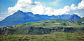 The Black Cuillin seen from Elgol.
 The north Cuillin viewed from Portree.
 Blà Bheinn from Loch Slapin.
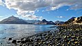 The Black Cuillin viewed from Loch Scavaig.
 Loch Coruisk in the Cuillin.
 Sgùrr nan Gillean.
 Sgùrr Alasdair, the highest peak.
 The 'Inaccessible Pinnacle', with climbers on the summit of Sgùrr Dearg.
 The Red Cuillin, with the Black Cuillin in the distance.


References
- "National Scenic Areas - Maps". SNH. 20 December 2010. Archived from the original on 12 June 2018. Retrieved 27 March 2018.
- "Cuillin Hills". Ainmean-Àite na h-Alba: Gaelic Place-Names of Scotland.
- D. Bennet & R. Anderson. The Munros: Scottish Mountaineering Club Hillwalkers Guide, pp. 258-275. Published 2016.
- R. Anderson & Tom Prentice. The Grahams & The Donalds - Scottish Mountaineering Club Hillwalkers' Guide, pp. 304–309. Published 2015.
- "The special qualities of the National Scenic Areas. Scottish Natural Heritage Commissioned Report No.374" (PDF). Scottish Natural Heritage. 2010. Retrieved 14 February 2018.
- "SPA description for Cuillins". Joint Nature Conservation Committee. 2011. Retrieved 21 February 2018.
- Ordnance Survey Landranger 1:50000, Sheet 32
- R. Milne & H Brown. The Corbetts and Other Scottish Hills - Scottish Mountaineering Club Hillwalkers' Guide, pp. 262–263. Published 2002.
- "Map: Cuillin Hills National Scenic Area" (PDF). Scottish Natural Heritage. 20 December 2010. Retrieved 21 February 2018.
- "National Scenic Areas". Scottish Natural Heritage. Retrieved 17 January 2018.
- "Cuillin Hills travel". Lonely Planet. Retrieved 21 February 2018.
- Drummond, Peter (1991). Scottish Hill and Mountain Names. Scottish Mountaineering Trust. pp. 3, 54–55.
- Ian R Mitchell. Scotland's Mountains Before the Mountaineers, p. 171. Published 2013, Luath Press.
- "The Roots of Volcanoes - Scottish Natural Heritage online". Scottish Natural Heritage. Archived from the original on 23 February 2018. Retrieved 22 February 2018.
- Chisholm, Hugh, ed. (1911). . Encyclopædia Britannica. Vol. 10 (11th ed.). Cambridge University Press. p. 638.
- Forbes, James D. (1846) Notes on the topography and geology of Cuchullin Hills in Skye, and on traces of ancient glaciers which they present. Edinburgh New Philosophical Journal No. 40. Pages 76-99.
- Forbes, James D. (1846) On the Viscous Theory of Glacier Motion Abstracts of the Papers Communicated to the Royal Society of London, Vol. 5, 1843 - 1850. pp. 595–596.
- McKirdy et al. (2007) pages 164-5 and 280.
- Harker, Alfred, (1904) The Tertiary Igneous Rocks of Skye. Geological Survey of Scotland Memoir.
- "Countryside and Landscape in Scotland - National Scenic Areas". Scottish Government. 4 July 2017. Retrieved 31 January 2018.
- Historic Environment Scotland. "Skye, Glen Brittle (11238)". Canmore. Retrieved 27 February 2018.
- Historic Environment Scotland. "Skye, River Sligachan (150648)". Canmore. Retrieved 27 February 2018.
- "Skye survey" Archived 28 September 2011 at the Wayback Machine. University of Edinburgh. Retrieved 15 March 2008.
- Historic Environment Scotland. "Skye, Rubh' An Dunain, 'Viking Canal' (11028)". Canmore. Retrieved 3 January 2013.
- Mackinnon, C. R. (1958). "The Clan Mackinnon: a short history". Archived from the original on 27 May 2010. Retrieved 30 April 2010.
- T. Marsh. The Isle of Skye, p. 170. Published 2012.
- Historic Environment Scotland. "Skye, Bloody Stone, Harta Corrie (11235)". Canmore. Retrieved 26 February 2018.
- MEM Donaldson. Wanderings in the Western Highlands and Islands, Revision. 2nd. Paisley. p. 147 RCAHMS Shelf Number: D.6.DON
- Historic Environment Scotland. "Skye, Coire Na Creiche (11233)". Canmore. Retrieved 11 November 2021.
- S. Johnson & J. Boswell (ed. R. Black). To the Hebrides: "Journey to the Western Isles of Scotland" and "Journal of a Tour to the Hebrides", pp. 257–258. Published by Birlinn, 2007.
- Ian R Mitchell, Scotland's Mountains Before the Mountaineers, p. 159. Published 2013, Luath Press.
- "Map Search". Who Owns Scotland. Retrieved 21 February 2018.
- "When the Black Cuillin mountains went on the market for £10m". The Scotsman. 12 October 2017. Retrieved 20 February 2018.
- "Black Cuillin may be gifted to nation in clan castle deal". The Scotsman. 8 May 2004. Retrieved 30 April 2012.
- "Introducing Sconser, Strathaird and, Torrin" (PDF). John Muir Trust. 2012. Retrieved 21 February 2018.
- "Homepage". John Muir Trust. Retrieved 21 February 2018.
- Elizabeth Buie. "Pop singer sells Skye estate to trust". The Herald. Retrieved 22 February 2011.
- Calum Smith (2020). The Black Cuillin: The Story of Skye's Mountains. Rymour Books. p. 179. ISBN 9780954070441.
- H. E. L. Porter (1974). "Leslie Garnet Shadbolt (1883–1973)" (PDF). Alpine Journal: 284–85.
- "Finlay Wild Breaks Cuillin Record - Again".
- Colin Wells, Running in Heaven Archived 2007-09-30 at the Wayback Machine. Sunday Herald (accessed 14 June 2007).
- "How to scramble: the Cuillin Ridge". The BMC. 4 August 2015. Retrieved 28 February 2018.
- Begley, Alastair (February 2014). "A Winter Cuillin Traverse". www.ukclimbing.com. Retrieved 19 March 2016.
- Lates, Mark. "The Cuillin Ridge: Tips for success by Mike Lates" (PDF). skyeguides.co.uk. Retrieved 19 March 2016.
- "Gaelic film up for Scots BAFTAs". BBC. 31 October 2007.
- "Sorley MacLean". Scottish Poetry Library. Retrieved 22 February 2018.
- "Runrig: Recovery". Discogs.com. Retrieved 22 February 2018.
- "Jethro Tull - Broadford Bazaar Lyrics". SongLyrics. Retrieved 22 February 2018.
- Merrill, Jamie (2 October 2014). "Video: Thrill-seeker Danny MacAskill takes death-defying ride along the 992-metre drop of The Cuillin Ridge". The Independent. Retrieved 4 October 2014.
- Ash, Russell (1973). Folklore, Myths and Legends of Britain. Reader's Digest Association Limited. p. 449. ISBN 9780340165973.
External links
Authority control | |
|---|---|
| General |
|
| National libraries | |
На других языках
[de] Cuillin Hills
Die Cuillin Hills (schottisch-gälisch: An Cuilthionn oder An Cuiltheann) sind eine felsige Gebirgslandschaft auf der schottischen Insel Skye, die zu den Inneren Hebriden gehört. Sie sind als National Scenic Area unter Schutz gestellt.[1]- [en] Cuillin
[fr] Cuillin
Le Cuillin, en gaélique écossais An Cuilthionn ou An Cuiltheann, est un massif de montagnes du Royaume-Uni situé en Écosse, sur l'île de Skye. Le Sgùrr Alasdair en est le point culminant avec 992 mètres d'altitude. Il s'agit d'un ancien volcan éteint et érodé.[it] Cuillin
I Cuillin (in lingua gaelica scozzese: An Cuilthionn o An Cuiltheann) è una catena di montagne rocciose situata sull'isola di Skye, in Scozia. I veri Cuillin sono conosciuti come Black Cuillin (Cuillin Neri), per distinguersi dai Red Cuillin (Cuillin Rossi, in gaelico scozzese na Beanntan Dearga, conosciuti localmente anche come Colline Rosse), lungo Glen Sligachan. Le colline dei Red Cuillin sono più basse, ed essendo meno rocciose, contano meno punti di arrampicata o salita.Другой контент может иметь иную лицензию. Перед использованием материалов сайта WikiSort.org внимательно изучите правила лицензирования конкретных элементов наполнения сайта.
WikiSort.org - проект по пересортировке и дополнению контента Википедии