geo.wikisort.org - Mountains
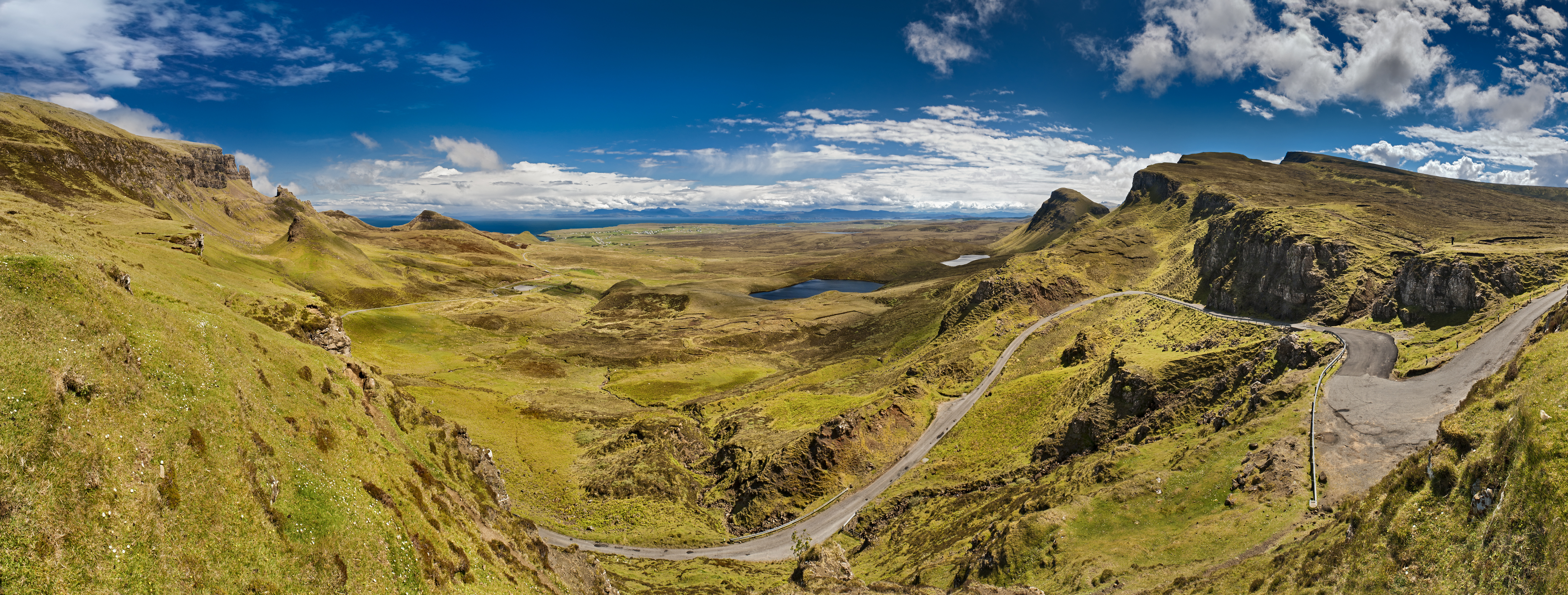
The Quiraing (Scottish Gaelic: A' Chuith-Raing) is a landslip on the eastern face of Meall na Suiramach, the northernmost summit of the Trotternish on the Isle of Skye, Scotland. The whole of the Trotternish Ridge escarpment was formed by a great series of landslips; the Quiraing is the only part of the slip still moving – the road at its base, near Flodigarry, requires repairs each year.
This article does not cite any sources. (December 2009) |
| Quiraing (Meall na Suiramach) | |
|---|---|
| A' Chuith-Raing (Scottish Gaelic) | |
 Quiraing | |
| Highest point | |
| Elevation | 543 m (1,781 ft) |
| Prominence | 44 m (144 ft) |
| Naming | |
| English translation | Round Fold |
| Language of name | Old Norse |
| Geography | |
| Location | Trotternish, Skye, Scotland |
| OS grid | NG446695 |
| Topo map | Ordnance Survey Landranger 23 |
Parts of the distinctive landscape have earned particular names. The Needle is a jagged 120-foot-high (37 m) landmark pinnacle, a remnant of landslipping. Northwest of it is The Table, a flat grassy area slipped down from the summit plateau, with vistas of the Torridon Hills and the mountains of Wester Ross. Southwest is the Prison, a pyramidal rocky peak which can look like a medieval keep when viewed from the right angle – the ascent of this is an airy scramble.
The name Quiraing comes from Old Norse Kví Rand, which means 'Round Fold'. Within the fold is The Table, an elevated plateau hidden amongst the pillars. It is said that the fold was used to conceal cattle from Viking raiders.
 "The Prison" from the main pathway.
 "The Needle" from "The Prison"


External links
 Media related to Quiraing at Wikimedia Commons
На других языках
[de] Quiraing
Der Quiraing (schottisch-gälisch Cuith-Raing) ist eine geologische Formation auf der schottischen Isle of Skye. Sie entstand durch geomorphologische Prozesse, vor allem Erdrutsche, und gehört zu den Inneren Hebriden. Auf der Halbinsel Trotternish gelegen, etwa 20 Kilometer nördlich der Inselhauptstadt Portree, ist sie eine der bekanntesten Sehenswürdigkeiten der Insel. Der Name Quiraing kommt aus dem Altnordischen Kvi Rand und bedeutet Gerundete Falte.- [en] Quiraing
[it] Quiraing
Il Quiraing è un altopiano vulcanico[1] dell'isola scozzese di Skye (Ebridi Interne), situato nella parte orientale del Meall na Suiramach, nella penisola di Trotternish[2][3][4].Другой контент может иметь иную лицензию. Перед использованием материалов сайта WikiSort.org внимательно изучите правила лицензирования конкретных элементов наполнения сайта.
WikiSort.org - проект по пересортировке и дополнению контента Википедии