geo.wikisort.org - Mountains
The Beaufortain Massif is a massif of the French Alps that straddles the departments of Savoie and Haute-Savoie, in the historical region of Savoy.
| Beaufortain Massif | |
|---|---|
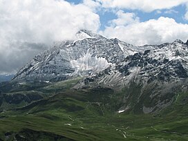
 Pointe de la Terrasse as seen from Rocher du Vent | |
| Highest point | |
| Elevation | 2,995 m (9,826 ft)[1] |
| Prominence | 1,028 m (3,373 ft)[1] |
| Coordinates | 45°41′10.71″N 6°34′8.63″E[2] |
| Naming | |
| Native name | Massif du Beaufortain (French) |
| Geography | |
 Beaufortain Massif Savoie and Haute-Savoie, Auvergne-Rhône-Alpes, France | |
| Parent range | French Alps |
It is bounded by the Arly river to the northwest, the Bon Nant to the northeast, and the Isère river as it runs through the Tarentaise Valley to the south. It is also crossed by the Dorinet and Doron de Beaufort rivers, and their tributaries, from north-east to south-west, at Beaufort level, and their tributaries.
It is surrounded by the Aravis Range, the Bauges Range, the Lauzière massif, the Vanoise massif, and the Mont-Blanc massif.
Peaks
| Name | Elevation |
|---|---|
| Roignais | 2,995 m (9,826 ft) |
| Combe Neuve | 2,961 m (9,715 ft) |
| Aiguille du Grand Fond | 2,920 m (9,580 ft) |
| Pointe de la Terrasse | 2,881 m (9,452 ft) |
| Grande Parei | 2,725 m (8,940 ft) |
| Pierra Menta | 2,714 m (8,904 ft) |
| Aiguilles de la Penaz | 2,688 m (8,819 ft) |
| Grand Mont | 2,686 m (8,812 ft) |
| Crêt du Rey | 2,633 m (8,638 ft) |
| Tête de la Cicle | 2,552 m (8,373 ft) |
| Crête des Gittes | 2,538 m (8,327 ft) |
| Mont Coin | 2,539 m (8,330 ft) |
| Mont Joly | 2,525 m (8,284 ft) |
| Aiguille Croche | 2,487 m (8,159 ft) |
| Pointe de la Grande Journée | 2,462 m (8,077 ft) |
| Mont Mirantin | 2,460 m (8,070 ft) |
| Roche Pourrie | 2,037 m (6,683 ft) |
| Mont d'Arbois | 1,833 m (6,014 ft) |
References
- "Le Roignais - peakbagger.com". peakbagger.com. Retrieved 9 March 2015.
- "Haute Route du Beaufortain". Savoie Mont Blanc.
Further reading
| Wikimedia Commons has media related to Beaufortain. |
- Hagenmuller, Christophe (2006). Les plus belles traces du Beaufortain. Naturalpes. ISBN 295278700X.
- Manon, Martial (2002). Panorama du Beaufortain. Les Savoisiennes. Montmélian: La Fontaine De Siloe. ISBN 2842062051.
На других языках
- [en] Beaufortain Massif
[fr] Massif du Beaufortain
Le massif du Beaufortain est un massif des Alpes françaises situé à cheval sur les deux départements de Savoie.[it] Alpi del Beaufortain
Le Alpi del Beaufortain (detto anche Massiccio del Beaufortain oppure Alpi Graie Nord-occidentali) sono un gruppo montuoso[1] delle Alpi Graie. Si trovano soprattutto nel dipartimento francese della Savoia ed in minor parte in quello dell'Alta Savoia. La vetta più elevata è il Roignais che raggiunge i 2.995 m s.l.m..Текст в блоке "Читать" взят с сайта "Википедия" и доступен по лицензии Creative Commons Attribution-ShareAlike; в отдельных случаях могут действовать дополнительные условия.
Другой контент может иметь иную лицензию. Перед использованием материалов сайта WikiSort.org внимательно изучите правила лицензирования конкретных элементов наполнения сайта.
Другой контент может иметь иную лицензию. Перед использованием материалов сайта WikiSort.org внимательно изучите правила лицензирования конкретных элементов наполнения сайта.
2019-2025
WikiSort.org - проект по пересортировке и дополнению контента Википедии
WikiSort.org - проект по пересортировке и дополнению контента Википедии