geo.wikisort.org - Bergen
Die Mourne Mountains (auch Mountains of Mourne; irisch Na Beanna Boirche) sind ein aus Granit bestehender Gebirgszug rund 50 km südlich der nordirischen Hauptstadt Belfast zwischen Newry und Newcastle in der Baronie Mourne (irisch Múrna) im County Down gelegen. Bekanntester Gipfel ist der Slieve Donard, mit 849 Metern der höchste Berg Nordirlands. Die Gegend ist als sogenannte Area of Outstanding Natural Beauty klassifiziert, hier soll auch der erste Nationalpark Nordirlands entstehen.
| Mourne Mountains | ||
|---|---|---|
 Blick auf die Mountains of Mourne | ||
| Höchster Gipfel | Slieve Donard (849 m ASL) | |
| Lage | Nordirland | |
| ||
| Koordinaten | 54° 10′ N, 6° 5′ W | |

Die Berge sind ein beliebtes Naherholungsgebiet und werden von vielen Touristen, Wanderern, Mountainbikefahrern und Bergsteigern aufgesucht. Nach einer Spendenaktion im Jahr 1993 erwarb der National Trust ein 5,26 km² großes Gebiet in den Bergen. In diesem liegen der Slieve Donard und der benachbarte Slieve Commedagh, mit 767 m der zweithöchste Berg in der Gegend. Eine Sehenswürdigkeit ist der Mourne Wall. Diese 35 km lange Trockenmauer wurde zwischen 1904 und 1922 errichtet und umgibt das Quellgebiet und die Stauseen die der Trinkwasserversorgung der Stadt Belfast dienen. Mit dieser Mauer sollten ursprünglich Schafe und Rinder aus dem Trinkwassergebiet ferngehalten werden.
Bilder
 Der Mourne Wall
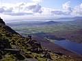 Silent Valley Stausee und Carlingford Lough
 Slieve Donard und Analong Wood
 Bergpanorama
 Blick Richtung Kilkeel und Irische See


Weblinks
- Offizielle Website der Mountains of Mourne
- Private Website mit Informationen zu den Mountains of Mourne (Memento vom 3. März 2001 im Internet Archive)

England
Arnside and Silverdale | Blackdown Hills | Bodmin Moor | Cannock Chase AONB | Chichester Harbour | Chiltern Hills | Cornwall AONB | Cotswolds | Cranborne Chase and West Wiltshire Downs | Dedham Vale | Dorset AONB | East Devon AONB | East Hampshire AONB | Forest of Bowland | High Weald | Howardian Hills | Isle of Wight AONB | Isles of Scilly | Kent Downs | Lincolnshire Wolds | Malvern Hills | Mendip Hills | Nidderdale | Norfolk Coast | North Devon AONB | North Pennines | Northumberland Coast | North Wessex Downs | Quantock Hills | Shropshire Hills | Solway Coast | South Devon | South Downs | South Hampshire Coast | Suffolk Coast and Heaths | Surrey Hills | Tamar Valley | Wye Valley
Wales
Anglesey | Clwydian Range | Moel Famau | Gower-Halbinsel | Lleyn-Halbinsel | Wye Valley
Nordirland
Antrim Coast and Glens | Binevenagh | Causeway Coast | Lagan Valley | Mourne Mountains | Ring of Gullion | Sperrin Mountains | Strangford and Lecale
На других языках
- [de] Mourne Mountains
[en] Mourne Mountains
The Mourne Mountains (/mɔːrn/ MORN; Irish: Beanna Boirche), also called the Mournes or Mountains of Mourne, are a granite mountain range in County Down in the south-east of Northern Ireland.[1] They include the highest mountains in Northern Ireland, the highest of which is Slieve Donard at 850 m (2,790 ft).[2] The Mournes are designated an Area of Outstanding Natural Beauty[3] and it has been proposed to make the area Northern Ireland's first national park.[4] The area is partly owned by the National Trust and sees many visitors every year.[5] The Mourne Wall crosses fifteen of the summits and was built to enclose the catchment basin of the Silent Valley and Ben Crom reservoirs.[fr] Montagnes de Mourne
Les montagnes de Mourne (en anglais : Mourne Mountains ; en irlandais : Beanna Boirche) sont un massif montagneux granitique situé dans le nord-est de l'île d'Irlande, au sud-est de l'Irlande du Nord.[ru] Морн
Морн (англ. Mourne Mountains, ирл. Beanna Boirche, «холмы Борхе»[1]) — гранитная горная гряда в ольстерском графстве Даун на юго-востоке Северной Ирландии (Великобритания). Окружающая местность носит статус Area of Outstanding Natural Beauty, и была первой, предложенной в качестве национального парка Северной Ирландии[2][3] (хотя вокруг этого существуют споры из-за того, что здесь работает около тысячи фермеров[3], и это предложение в целом повлияет на местные общины, бюрократию и цены на жильё[4]).Другой контент может иметь иную лицензию. Перед использованием материалов сайта WikiSort.org внимательно изучите правила лицензирования конкретных элементов наполнения сайта.
WikiSort.org - проект по пересортировке и дополнению контента Википедии