geo.wikisort.org - Montagne
Les montagnes de Mourne (en anglais : Mourne Mountains ; en irlandais : Beanna Boirche) sont un massif montagneux granitique situé dans le nord-est de l'île d'Irlande, au sud-est de l'Irlande du Nord.
Cet article est une ébauche concernant la montagne et l’Irlande du Nord.
Vous pouvez partager vos connaissances en l’améliorant (comment ?) selon les recommandations des projets correspondants.
| Montagnes de Mourne | ||
| Localisation des Montagnes de Mourne en Irlande. | ||
| Géographie | ||
|---|---|---|
| Altitude | 849 m, Slieve Donard | |
| Administration | ||
| Pays | ||
| Nation constitutive | ||
| Comté | Down | |
| Géologie | ||
| Roches | Granite | |
| modifier |
||

Toponymie
En irlandais, les montagnes se nomment Beanna Boirche, littéralement : « les sommets de la région des sommets »[1], beann ou binn signifiant « pic » ou « falaise »[2].
En anglais, elles portent le nom de Mourne Mountains, Mountains of Mourne, ou simplement Mournes (historiquement : Morne)[réf. nécessaire], terme dérivé du clan gaël Múghdhorna (en irlandais : Múrna)[1].
Situation
Les montagnes de Mourne se situent dans la paroisse civile de Kilkeel, dans la baronnie de Mourne, dans le comté de Down dans le Sud-Est de l'Irlande du Nord, dans le nord-est de l'île d'Irlande[1].
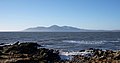 Les montagnes de Mourne vues depuis St. John's Point.
 Paysage des montagnes de Mourne avec le mur de Mourne.


Notes et références
- (en) « Mourne Mountains, County Down », sur Place Names NI (consulté le ).
- (en) « Beanna Boirche / Mourne Mountains », sur Placenames Database of Ireland (logainm.ie) (consulté le ).
 Portail de la montagne
  Portail de l’Irlande du Nord
На других языках
[de] Mourne Mountains
Die Mourne Mountains (auch Mountains of Mourne; irisch Na Beanna Boirche) sind ein aus Granit bestehender Gebirgszug rund 50 km südlich der nordirischen Hauptstadt Belfast zwischen Newry und Newcastle in der Baronie Mourne (irisch Múrna) im County Down gelegen. Bekanntester Gipfel ist der Slieve Donard, mit 849 Metern der höchste Berg Nordirlands. Die Gegend ist als sogenannte Area of Outstanding Natural Beauty klassifiziert, hier soll auch der erste Nationalpark Nordirlands entstehen.[en] Mourne Mountains
The Mourne Mountains (/mɔːrn/ MORN; Irish: Beanna Boirche), also called the Mournes or Mountains of Mourne, are a granite mountain range in County Down in the south-east of Northern Ireland.[1] They include the highest mountains in Northern Ireland, the highest of which is Slieve Donard at 850 m (2,790 ft).[2] The Mournes are designated an Area of Outstanding Natural Beauty[3] and it has been proposed to make the area Northern Ireland's first national park.[4] The area is partly owned by the National Trust and sees many visitors every year.[5] The Mourne Wall crosses fifteen of the summits and was built to enclose the catchment basin of the Silent Valley and Ben Crom reservoirs.- [fr] Montagnes de Mourne
[ru] Морн
Морн (англ. Mourne Mountains, ирл. Beanna Boirche, «холмы Борхе»[1]) — гранитная горная гряда в ольстерском графстве Даун на юго-востоке Северной Ирландии (Великобритания). Окружающая местность носит статус Area of Outstanding Natural Beauty, и была первой, предложенной в качестве национального парка Северной Ирландии[2][3] (хотя вокруг этого существуют споры из-за того, что здесь работает около тысячи фермеров[3], и это предложение в целом повлияет на местные общины, бюрократию и цены на жильё[4]).Другой контент может иметь иную лицензию. Перед использованием материалов сайта WikiSort.org внимательно изучите правила лицензирования конкретных элементов наполнения сайта.
WikiSort.org - проект по пересортировке и дополнению контента Википедии