geo.wikisort.org - Island
Zubair Group, Al Zubair Group or Zubayr Group (Arabic: مجموعة جزر الزبير, or simply: جزر الزبير) is a group of 10 major volcanic islands, on top of an underlying shield volcano in the Red Sea, which reach a height of 191 m (627 ft) above sea level. The volcano has continued to erupt in historic times. The islands currently belong to Yemen.
| Zubair Group | |
|---|---|
 Zubair Group Location | |
| Highest point | |
| Elevation | 191 m (627 ft) |
| Coordinates | 15°3′0″N 42°10′0″E |
| Geography | |
| Location | |
| Geology | |
| Mountain type | Shield Volcano |
| Last eruption | September - October 2013 |
Islands
The largest island is Zubair, which is one of the younger islands. Other young islands are Center Peak, Saba, Haycock, and Saddle. Saddle Island has had eruptions in historic times.
The volcano was built on a NNW-SSE rift line. It began with a period of explosive eruptions, then a period of quiescence followed, during which time marine erosion took place. This was followed by a period of both explosive and effusive eruption activity, building up the Stark and Barren group of islands that exist today. This period of eruption has continued into historic times.
Historic eruptions
1824 eruption
A small (VEI 2) eruption took place in 1824 on Saddle Island, with low level explosive activity. An eruption may have taken place on August 14, 1846, but this event is uncertain.
2011–2012 eruption
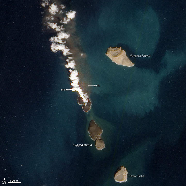
A volcanic eruption took place 19 December 2011 from the seabed. Satellite images showed a plume in the sea between Haycock and Rugged Islands. Fishermen reported lava fountaining 30 m above the sea. The submarine eruption has built a new island in the group, in between Rugged and Haycock Islands. Water entering the vent had created Surtseyan activity resulting in the release of steam and an ash plume.[1][2][3]
As of 12 January 2012, the new island had grown to around 530 by 710 meters (1,700 by 2,300 feet) across and had begun effusive activity, It was named Sholan Island.
Satellite images taken on 15 January 2012 showed that the eruption had stopped, leaving a newborn island behind.[4] A satellite photo taken on February 15 shows the new island has a crater lake.[citation needed]
2013 eruption
On September 28, 2013, a new submarine eruption began southwest of the 2011–2012 eruption site, with water discoloration and a significant steam plume reported. Scientists estimated that the eruption was taking place less than 100 m below the surface, meaning that a new surtseyan phase was a possibility.[5] The activity at the site continued into October, with a large steam plume visible on satellite and confirmed by video from locals.[6][7] In late October, a new island emerged from the ocean.[8]
This island has been named Jadid Island while the one created in 2011 has been named Sholan Island.[9] By the summer of 2016 neither island was visible on satellite photos.
Visitor attractions
Diving, sightseeing, wildlife viewing and volcano trekking are popular activities for tourists and visitors. The islands are uninhabited.[10]
References
- Nasa picture
- Earth’s newest island emerges from depths of the Red Sea Archived January 7, 2012, at the Wayback Machine
- Israel, Brett (December 28, 2011). "New Island Rises in the Red Sea". LiveScience.com. Retrieved 2015-07-31.
- Surtseyan eruption along the coast of Yemen forms a new island – January 15 new ALI satellite image
- Volcanic activity worldwide 29 Sep 2013: Sakurajima, Jebel Zubair, Etna (Volcano Discovery, Sep 29, 2013)
- Jebel Zubair volcano (Red Sea, Yemen) activity update (Volcano Discovery, Oct 2, 2013)
- Jebel Zubair volcano (Red Sea, Yemen) activity update, Oct 11, 2013
- Jebel Zubair (Red Sea, Yemen): new island, current activity unknown (Volcano Discovery, Nov 3, 2013)
- Oskin, Becky; SPACE.com (May 30, 2015). "Red Sea Parts for 2 New Islands". Scientific American. Retrieved 2015-07-31.
- Diving in Al Zubair group of islands
External links
- "Zubair Group". Global Volcanism Program. Smithsonian Institution.
| Arabian Sea | |
|---|---|
| Guardafui Channel | |
| Red Sea |
|
1Socotra island became under the control of United Arab Emirates since April 30, 2018
| |
На других языках
[de] Zubair-Archipel
Der Zubair-Archipel (arabisch جزر الزبير, DMG Ǧuzur az-Zubair) ist eine etwa fünfzig Kilometer von der Westküste des Jemen entfernte Inselgruppe im Roten Meer. Sie gehört zum dortigen mittelozeanischen Rücken.[1]- [en] Zubair Group
[it] Gruppo Zubair
Il Gruppo Zubair, Gruppo Al Zubair o Gruppo Zubayr (in arabo: مجموعة جزر الزبير, o semplicemente: جزر الزبير) è un gruppo di 10 isole vulcaniche principali, in cima a un vulcano a scudo sottostante nel Mar Rosso, che raggiungono un'altezza di 191 m sul livello del mare. Il vulcano ha continuato a eruttare in tempi storici. Le isole appartengono attualmente allo Yemen.[ru] Эз-Зубайр (острова)
Эз-Зубайр[1] (араб. الزبير جزر) — группа островов вулканического происхождения в Красном море у западного побережья Йемена. Максимальная высота — 191 м. Острова представляют собой вершины активных подводных вулканов, принадлежат Йемену.Другой контент может иметь иную лицензию. Перед использованием материалов сайта WikiSort.org внимательно изучите правила лицензирования конкретных элементов наполнения сайта.
WikiSort.org - проект по пересортировке и дополнению контента Википедии