geo.wikisort.org - Island
Kamaran Island (Arabic: كمران Kamarān) is the largest Yemeni island in the Red Sea. The 108 km2 (42 sq mi) island is 18 km (11 mi) long and 7 km (4.3 mi) wide and is strategically located at the southern end of the Red Sea.[1] It is a "shelf island" located in the shallow waters of the Arabian peninsula's continental shelf with coral reefs surrounding three sides of the island. The population numbers 2,200.[2]
Native name: كمران Kamarān | |
|---|---|
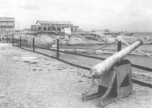
 The Harbour | |
 Kamaran seen from space | |
 Kamaran | |
| Geography | |
| Location | Red Sea |
| Coordinates | 15°20′19.993″N 42°35′23.888″E |
| Administration | |
Kamaran is generally flat, with a few hills in the south. Its highest point is Jabal Yaman (24 meters high), situated about three kilometers from Ra's al Yaman, the southeastern cape of the island.
History

In 1513, Afonso de Albuquerque spent three months on the island after the abortive siege of Aden. The Portuguese stay was thoroughly unpleasant marked by a short supply of food, a small smattering of only goats and camels, alongside the outbreak of a mysterious epidemic that caused fever and blood clogging.[3]
During the second part of the 19th century, the island was occupied by the Turks who built a quarantine station for pilgrims from East Africa, the Persian Gulf, India and the East conducting the hajj by sea to the Ottoman-controlled Muslim holy city of Mecca.
During the early months of World War I, there was a debate among the British on the suitability of occupying Kamaran and the other Turkish-held Red Sea islands such as the Farasan Islands. Those who opposed the move pointed out that when war broke out, Great Britain had solemnly declared that it had no territorial ambitions in the area; even a temporary occupation might be seen by the Arabs, particularly the Imam of Yemen, as a breach of that promise. Finally, the decision was taken to occupy Kamaran and on the 9th of June 1915, the RMS Empress of Russia landed an armed party on the island, previously evacuated by the Turkish garrison. G. A. Richardson, formerly vice-consul at Hudaydah and Kamaran, also disembarked to act as Political Officer with additional responsibility for Police, Treasury and Customs.[4] While the British continued to administer Kamaran from Aden, they never declared formal possession.

In 1923, the Treaty of Lausanne, which divided up the defeated Ottoman Empire, declared an end to its sovereignty over the Arabian Peninsula and adjacent islands, whose future was to be "settled by the parties concerned" without specifying those parties. Britain continued to administer the island despite the objections of Yemen which claimed sovereignty over the island. In 1949, Britain formally declared the governor of Aden to be the governor of Kamaran but the island did not become a part of the colony.[5]
Quarantine station

After the departure of the Turks, an international control was exercised over the quarantine station, but it was in fact placed under British administration. In anticipation of a vast increase in the number of the faithful from British India, the Dutch East Indies, etc. who would make the pilgrimage the camp was greatly extended. Long lines of barrack-like sleeping quarters were constructed[when?] where the Turks had provided only wattle huts. Big disinfecting plants were installed where the pilgrims went through an ordeal of cleansing on a production line basis. A power station was built. The local water supply being inadequate, a massive distillation plant was introduced to make sea water fit for drinking. There were carpenters’ shops, machine shops, a small railway to transport fuel and stores, a wireless station, a fine landing stage, a cantonment of officials’ bungalows. This proved a bonanza for the islanders. They prospered on this trade in potential disease among the devout, and the population grew. In the village of Kamaran, the only settlement apart from a few isolated groups of fishermen's huts, fine houses and a magnificent mosque went up, and a lively trade in pilgrim requirements was conducted with the mainland.[6]
Norman Lewis describes that, during Thompson's commissionership, resident islanders worked primarily as pearl divers and would rarely last past the age of 50 due to the harsh work-induced stresses.[7]
However, this prosperity was short-lived. Determined to control the pilgrimage in all its aspects, the Saudi Arabian Government decided to construct its own quarantine station and to insist that Kamaran be by-passed. Soon, the long lines of buildings in the camps lay empty and deserted; a handful of men maintained was had become a ghost town while arrangements were debated for its breaking up and disposal.[6]
End of the British presence
On 30 November 1967, Kamaran became a part of the People's Democratic Republic of Yemen (South Yemen) upon its independence from Britain, but was seized by the adjacent Yemen Arab Republic (North Yemen) in 1972[8] and became a part of a unified Yemen in 1990.
British Commissioners
- June 1915 - 191. D.G.L. Shaw - Commander
- c.1922 - 1935 Captain Guy Vyvian Wickham
- 1930s - c.1945 David Thompson
- c.1945 - 1952 Major Thomson British Army 1948
- 1952 - 1954? R.G.W.E. Alban (b. 1899 - d. 19..)
- 1954? - 30 November 1967 Archie Wilson
Postal history
Kamaran Island had an Ottoman post office until 1915 and had a sub-post office of Aden beginning in 1924. From 1967, it was a postal territory of South Yemen, from 1972 of North Yemen, and from 1990 of the unified Republic of Yemen.
Notes
- "Island Directory". UN System-wide Earthwatch.. Various other sources give significantly different figures including 181, 130, and 57 km2 (22 sq mi). This photo Archived 2006-11-22 at the Wayback Machine from the period of British rule gives a figure of 207 km2 (80 sq mi).
- Farlex Encyclopedia
- Roger Crowley, "Conquerors: How Portugal Forged the First Global Empire", p. 295.
- John Baldry, "British Naval Operations against Turkish Yaman 1914-1919", Arabica, T. 25, Fasc. 2 (Jun., 1978), p. 163.
- The Kamaran Order in Council, 1949 (SI 1949/137)
- Nigel Groom, "The Island of Two Moons: Kamaran 1954", British-Yemeni Society Journal, 2002.
- Lewis, Norman (2001). A Voyage by Dhow. London: Jonathan Cape. ISBN 0-224-06171-2.
- Daniel McLaughlin, Yemen: The Bradt Travel Guide (2007) pp.162-3. ISBN 1-84162-212-5
Sources and external links
- WorldStatesmen- Yemen
- Kamaran Island page
- Kamaran Island Photo Gallery
- Nigel Groom. The island of two moons: Kamaran 1954. at The British-Yemeni Society webpage
- Small Islands in the Near East
| Arabian Sea | |
|---|---|
| Guardafui Channel | |
| Red Sea |
|
1Socotra island became under the control of United Arab Emirates since April 30, 2018
| |
На других языках
[de] Kamaran
Kamaran (arabisch كمران Kamarān) ist die größte im Roten Meer liegende Insel des Jemen.- [en] Kamaran
[es] Kamaran
La isla Kamaran (en árabe, كمران [Kamarān]) es la mayor de las islas bajo dominio de Yemen en el mar Rojo. Posee una superficie de 108 km², con una longitud de 18 km y 7 km de ancho. Se encuentra ubicada en una posición estratégica en el extremo sur del mar Rojo.[1] Es una isla continental que se encuentra en aguas poco profundas de la plataforma continental de la península de Arabia con arrecifes de coral que rodean tres de sus laterales.[fr] Kamaran
Kamaran (arabe : كمران Kamarān) est une île de la mer Rouge, appartenant au Yémen. Elle constitue un district à part entière au sein du gouvernorat d'al-Hodeïda. Elle est peuplée de 2 465 habitants (2004)[1].[it] Kamaran
L'isola di Kamaran (in arabo كمران ) è la più grande isola yemenita nel mar Rosso e si trova alla coordinate 15.35 Nord, 42.5667 Est, occupando una posizione strategica nel mar Rosso. L'isola ha una superficie di circa 108 km² e misura circa 18 km di lunghezza per 7 km di larghezza.[ru] Камаран
Камаран (араб. كمران) — крупнейший остров, принадлежащий Йемену в Красном море.Другой контент может иметь иную лицензию. Перед использованием материалов сайта WikiSort.org внимательно изучите правила лицензирования конкретных элементов наполнения сайта.
WikiSort.org - проект по пересортировке и дополнению контента Википедии