geo.wikisort.org - Island
Tiverton is a town in Newport County, Rhode Island, United States. The population was 16,359 at the 2020 census.
Tiverton, Rhode Island | |
|---|---|
Town | |
 Nanaquaket Pond, Tiverton, RI | |
 Location of Tiverton in Newport County, Rhode Island | |
| Coordinates: 41°37′35″N 71°12′40″W | |
| Country | United States |
| State | Rhode Island |
| County | Newport |
| Settled | 1659 |
| Incorporated (Massachusetts) | June 14, 1694 |
| Annexed by Rhode Island | January 27, 1747 |
| Area | |
| • Total | 36.3 sq mi (94.1 km2) |
| • Land | 29.4 sq mi (76.0 km2) |
| • Water | 7.0 sq mi (18.0 km2) |
| Elevation | 167 ft (51 m) |
| Population (2020) | |
| • Total | 16,359 |
| • Density | 558/sq mi (215.3/km2) |
| Time zone | UTC−5 (Eastern (EST)) |
| • Summer (DST) | UTC−4 (EDT) |
| ZIP Code | 02878 |
| Area code | 401 |
| FIPS code | 44-70880[2] |
| GNIS feature ID | 1220066[1] |
| Website | www |
Geography
Tiverton is located on the eastern shore of Narragansett Bay, across the Sakonnet River from Aquidneck Island (also known as the Island of Rhode Island). Together with the adjacent town of Little Compton, the area is disconnected from the rest of the state of Rhode Island. The northern portion of the town is located on Mount Hope Bay.
Much of the town is located along a granite ridge which runs in a north–south direction, rising approximately 170 feet in elevation from the bay. A large section of exposed granite can be observed at the highway cut for Route 24, near the Main Road interchange.
According to the United States Census Bureau, Tiverton has a total area of 36.3 square miles (94.1 km2), of which 29.4 square miles (76.0 km2) is land and 18.0 km2 (7.0 sq mi; 19.16%) is water.
The northern portion of greater Tiverton is also known as North Tiverton, Rhode Island.
Demographics
| Historical population | |||
|---|---|---|---|
| Census | Pop. | %± | |
| 1790 | 2,453 | — | |
| 1800 | 2,717 | 10.8% | |
| 1810 | 2,837 | 4.4% | |
| 1820 | 2,875 | 1.3% | |
| 1830 | 2,905 | 1.0% | |
| 1840 | 3,183 | 9.6% | |
| 1850 | 4,699 | 47.6% | |
| 1860 | 1,927 | −59.0% | |
| 1870 | 1,808 | −6.2% | |
| 1880 | 2,505 | 38.6% | |
| 1890 | 2,837 | 13.3% | |
| 1900 | 2,977 | 4.9% | |
| 1910 | 4,032 | 35.4% | |
| 1920 | 3,894 | −3.4% | |
| 1930 | 4,578 | 17.6% | |
| 1940 | 5,018 | 9.6% | |
| 1950 | 5,659 | 12.8% | |
| 1960 | 9,461 | 67.2% | |
| 1970 | 12,559 | 32.7% | |
| 1980 | 13,526 | 7.7% | |
| 1990 | 14,312 | 5.8% | |
| 2000 | 15,260 | 6.6% | |
| 2010 | 15,780 | 3.4% | |
| 2020 | 16,359 | 3.7% | |
| U.S. Decennial Census[3][4] | |||
As of the census[2] of 2000, there were 15,260 people, 6,077 households, and 4,405 families residing in the town. The population density was 519.8 inhabitants per square mile (200.7/km2). There were 6,474 housing units at an average density of 220.5 per square mile (85.1/km2). The racial makeup of the town was 97.98% White, 0.43% Black or African American, 0.17% Native American, 0.39% Asian, 0.03% Pacific Islander, 0.22% from other races, and 0.79% from two or more races. Hispanic or Latino of any race were 0.68% of the population.
There were 6,077 households, out of which 29.6% had children under the age of 18 living with them, 60.2% were married couples living together, 8.8% had a female householder with no husband present, and 27.5% were non-families. Of all households 23.1% were made up of individuals, and 11.7% had someone living alone who was 65 years of age or older. The average household size was 2.51 and the average family size was 2.95.
The age distribution of the population of Tiverton was 22.1% under the age of 18, 5.9% from 18 to 24, 29.0% from 25 to 44, 26.6% from 45 to 64, and 16.5% 65 years older. The median age was 41 years. For every 100 females, there were 94.9 males. For every 100 females age 18 and over, there were 92.6 males aged 18 or more.
The median income for a household in the town was $49,977, and the median income for a family was $58,917. Males had a median income of $41,042 versus $29,217 for females. The per capita income for the town was $22,866. About 2.9% of families and 4.5% of the population were below the poverty line, including 2.7% of those under age 18 and 9.1% of those age 65 or over.
Beaches
The two beaches in Tiverton are Fogland Beach and Grinnell's Beach. Both beaches are located on the Sakonnet River. Strong cool breezes blow throughout the year.
Fogland Beach has lifeguards, and also can be used for fishing, walking, and wildlife/nature observation. It is popular destination for windsurfing and kite-surfing with rentals being available. The town also offers kayaking and paddleboarding programs through a local company.[5]
Grinnell's Beach provides an excellent windsurfing area, and a view of the Sakonnet River and Portsmouth shoreline. Amenities include changing rooms, showers, and a children's playground.[5]
History
Early

Tiverton was incorporated by English colonists in 1694 within Bristol County in the Province of Massachusetts Bay. As well as being part of Old Dartmouth. In 1746, in the final settlement of a long colonial boundary dispute between Rhode Island and Massachusetts, Tiverton—together with its fellow towns along the eastern shore of Narragansett Bay, Barrington, Bristol and Little Compton, and the town of Cumberland, to the north of Providence—were annexed to Rhode Island by Royal Decree. Tiverton was incorporated as a town in 1747. Until that year, Tiverton also controlled the area of East Freetown, Massachusetts, as an outpost. The boundary settlement of 1746 had put East Freetown in Massachusetts, and in 1747 it was purchased by Freetown.
Men from the Tiverton outpost took part in the Battle of Freetown, on May 25, 1778, during the Revolutionary War. On the 31st of that month, a party of about 150 British regulars[6] of the 22nd Regiment under the command of Lieutenant-Colonel Campbell attacked the town.[7] Rivington's Gazette reported that the British were making a preemptive attack based on intelligence that the American militia at Tiverton was preparing an attack against them.[7] However, another report in the New Hampshire Gazette stated the militia was waiting in prepared defensive positions. The result of this skirmish was two British killed, several more wounded, and some fire damage to the lower mill in Tiverton. None of the militiamen were wounded or killed.[6]
For about three years during the war, December 1776 – October 1779, the island of Rhode Island, now known as Aquidneck Island, was occupied by the British. During this time, Tiverton was a refuge for Americans fleeing this occupation, and a mustering place for colonial forces gathering to drive out the British. The British occupying forces were eventually withdrawn strategically, as General Clinton marshaled his forces for the 1780 British invasion of South Carolina.[8])
In its early days, Tiverton was chiefly a farming community with some fishing and boat construction. Until 1900 the manufacture of menhaden oil, a fish derivative, was one of the primary industrial pursuits. Cotton and woolen mills were established as early as 1811, when Colonel Joseph Durfee established a spinning mill at Cook Pond, in what it now the city of Fall River, Massachusetts.
In 1856, the northern part of the town was set apart from Tiverton, and renamed Fall River, Rhode Island, by the Rhode Island General Assembly.[9] On March 1, 1862, in a case between the states that reached the United States Supreme Court, both Fall Rivers were made part of Massachusetts and the state boundary was placed in its current location near State Avenue.[10]
Mark's Stadium is a former soccer stadium located in North Tiverton, Rhode Island. During the 1920s and early 1930s, it was the home of Fall River Marksmen, one of the era’s most successful soccer teams. It is one of the earliest examples of a soccer-specific stadium in the United States.[11] After the demise of the Marksmen, the stadium was used as a home ground by other local teams, most notably Fall River F.C. and Ponta Delgada S.C.
Recent events
In July 1997 the National Weather Service (NWS) based in Taunton, Massachusetts established a cooperative weather station in the Stone Bridge Village section of town. Named Tiverton-2SW, this station serves as an official meteorological recording station for the town of Tiverton. Data from Tiverton-2SW is collected by the NWS in Taunton, Massachusetts as well as the National Climatic Data Center in Asheville, North Carolina.
As of 2006, retail shops are the major employers in the town. Since the mid-20th century, Tiverton has grown as a summer resort and residential area, and as a suburb of Fall River, Massachusetts. During the 1960s, Route 24 was constructed through the northern part of the town, connecting Tiverton with Newport, Rhode Island via the Sakonnet River Bridge.[12]
In 2002, contaminated soil, including some soil that was blue, was discovered in the Bay Street neighborhood of Tiverton.[13] In 2003, private property testing began. Contaminants including arsenic, lead, cyanide, and more were found at levels above residential exposure guidelines. Residents have been prohibited from digging in the soil. ENACT (Environmental Neighborhood Awareness Committee of Tiverton) advocates on behalf of the community.[14] Property values in the neighborhood have plummeted due to the contamination and the moratorium on digging soil, which meant that residents of this neighborhood have lost their home equity. One of ENACT's successes has been the passage of legislation to create the Environmentally Contaminated Home Ownership (ECHO) loan program, which provides loans for people whose home equity has been sharply reduced due to contamination.[15] The Rhode Island Department of Environmental Management (RIDEM) has been involved in developing work plans to treat the contamination.[16]
In 2015, the Town was recognized as a Stormready Community by the National Weather Service.
On September 1, 2018 the Tiverton Casino Hotel (now Bally's Tiverton) was opened to the public, after Twin River Worldwide Holdings closed the Newport Grand Casino and moved its gaming license to the new facility.[17][18]
On May 9, 2021 a brush fire broke out near the Stafford Pond area and burned 50 acres of forest before finally being put out
Climate
| Climate data for Tiverton, Rhode Island (1991–2020 normals, extremes 1998–present | |||||||||||||
|---|---|---|---|---|---|---|---|---|---|---|---|---|---|
| Month | Jan | Feb | Mar | Apr | May | Jun | Jul | Aug | Sep | Oct | Nov | Dec | Year |
| Record high °F (°C) | 63 (17) |
66 (19) |
75 (24) |
90 (32) |
96 (36) |
100 (38) |
103 (39) |
101 (38) |
96 (36) |
84 (29) |
74 (23) |
71 (22) |
103 (39) |
| Average high °F (°C) | 38.5 (3.6) |
41.3 (5.2) |
49.0 (9.4) |
60.0 (15.6) |
70.1 (21.2) |
79.3 (26.3) |
84.9 (29.4) |
84.0 (28.9) |
76.9 (24.9) |
64.3 (17.9) |
52.7 (11.5) |
43.3 (6.3) |
62.0 (16.7) |
| Daily mean °F (°C) | 31.0 (−0.6) |
32.9 (0.5) |
39.7 (4.3) |
49.6 (9.8) |
59.6 (15.3) |
68.8 (20.4) |
74.9 (23.8) |
74.0 (23.3) |
67.1 (19.5) |
55.4 (13.0) |
44.8 (7.1) |
36.4 (2.4) |
52.8 (11.6) |
| Average low °F (°C) | 23.6 (−4.7) |
24.5 (−4.2) |
30.3 (−0.9) |
39.3 (4.1) |
49.0 (9.4) |
58.4 (14.7) |
65.0 (18.3) |
64.0 (17.8) |
57.3 (14.1) |
46.6 (8.1) |
37.0 (2.8) |
29.5 (−1.4) |
43.7 (6.5) |
| Record low °F (°C) | −5 (−21) |
−7 (−22) |
7 (−14) |
20 (−7) |
33 (1) |
40 (4) |
51 (11) |
51 (11) |
38 (3) |
29 (−2) |
13 (−11) |
5 (−15) |
−7 (−22) |
| Average precipitation inches (mm) | 4.01 (102) |
3.84 (98) |
5.55 (141) |
4.50 (114) |
3.57 (91) |
3.66 (93) |
2.96 (75) |
3.81 (97) |
3.93 (100) |
4.54 (115) |
4.11 (104) |
4.91 (125) |
49.39 (1,255) |
| Average snowfall inches (cm) | 10.9 (28) |
11.3 (29) |
7.4 (19) |
0.6 (1.5) |
0.0 (0.0) |
0.0 (0.0) |
0.0 (0.0) |
0.0 (0.0) |
0.0 (0.0) |
0.0 (0.0) |
0.6 (1.5) |
7.3 (19) |
38.1 (97) |
| Average precipitation days (≥ 0.01 in) | 12.3 | 11.4 | 11.7 | 13.1 | 13.1 | 11.5 | 9.8 | 9.1 | 9.4 | 11.7 | 9.9 | 12.6 | 135.6 |
| Average snowy days (≥ 0.1 in) | 5.2 | 5.2 | 3.3 | 0.4 | 0.0 | 0.0 | 0.0 | 0.0 | 0.0 | 0.0 | 0.4 | 3.4 | 17.9 |
| Source: NOAA[19][20][21] | |||||||||||||
Historic places
- Bourne Mill
- Cook-Bateman Farm
- First Baptist Church of Tiverton
- Fort Barton Site
- Osborn-Bennett Historic District
- Tiverton Four Corners Historic District
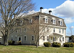 The main house of the Cook-Bateman Farm
 The First Baptist Church, known as the "Old Stone Church"
 The Thomas Bennett Homestead in the Osborn-Bennett Historic District
 The Soule-Seabury Mansion in the Tiverton Four Corners Historic District


Notable people
Education
Tiverton has five public schools: Poccasset Elementary School, Fort Barton Elementary School, Ranger Elementary School (recently demolished and rebuilt), Tiverton Middle School, and Tiverton High School.[24] The town is its own district and a part of the Newport County district.


Library
The Tiverton Public Library was chartered by the state in 1927.[25] The library was housed in several locations around town over the years.[25]
In June 2015 a new 24,000 square foot building was opened, incorporating a meeting hall, teen room, cafe, children's library, and public courtyard spaces.[26] The new building, designed by Union Studio architects, features a clock tower and gabled ends.[27] The new library received an AIA Rhode Island Design Award for Merit in 2018.[27]
A branch, the Union Public Library located at 3832 Main Road and part of the Tiverton Four Corners Historic District, has operated on that site almost continuously since 1820, although the current Early Victorian building dates from 1868. A paid staff member is assisted by volunteers from the Union Public Library Association to provide a reading room and library services.[28][29]
See also
 Rhode Island portal
References
Notes
- U.S. Geological Survey Geographic Names Information System: Tiverton, Rhode Island
- "U.S. Census website". United States Census Bureau. Retrieved January 31, 2008.
- "Census of Population and Housing". Census.gov. Retrieved June 4, 2016.
- Snow, Edwin M. (1867). Report upon the Census of Rhode Island 1865. Providence, RI: Providence Press Company.
- "Tiverton Home". ri.gov. Archived from the original on May 30, 2013.
- "Attempt to Burn Tiverton". New Hampshire Gazette. June 16, 1778. Retrieved August 6, 2014.
- "Attempt to Burn Tiverton". Rivington's Gazette. June 6, 1778. Retrieved August 6, 2014.
- McEvedy, p.62
- "Fall River, Rhode Island". mac.com. Archived from the original on July 28, 2008.
- "Ambrose F. Keeley Library the Information Center of B.M.C. Durfee High School: History of Fall River, Massachusetts and Rhode Island Boundary question" (PDF). www.sailsinc.org.
- David Wangerin, Soccer in a Football World – The Story of America’s Forgotten Game, 2006
- "Infrastructure". www.haleyaldrich.com. Archived from the original on May 9, 2008.
- "RIDEM - Bay Street Tiverton Study Area". www.dem.ri.gov.
- ENACT, www.enactri.org
- http://www.brownalumnimagazine.com/under_the_elms/civil_actions.htmlSchwartzapfel%5B%5D, Beth. "Civil Actions", Brown Alumni Magazine, Nov/Dec 2007
- Oct 4, 2005 ENACT presentation to Tiverton residents.
- Shaun Towne; Steph Machado; Shiina Losciuto (August 28, 2018). "Newport Grand closes its doors, making way for Tiverton casino". WPRI-TV. Retrieved April 1, 2019.
- Scott Barrett (September 1, 2018). "Tiverton casino opens with excitement, protest". Newport Daily News. Retrieved April 1, 2019.
- "NowData – NOAA Online Weather Data". National Oceanic and Atmospheric Administration. Retrieved May 30, 2021.
- "Station: Tiverton, RI". U.S. Climate Normals 2020: U.S. Monthly Climate Normals (1991-2020). National Oceanic and Atmospheric Administration. Retrieved May 30, 2021.
- "Monthly highest max temperature and monthly lowest min temperature for Tiverton, RI". Applied Climate Information System. Retrieved May 30, 2021.
- Adolphus Washington Greely, Explorers and Travellers (C. Scribner's Sons: 1904), p. 88.
- James L. Yarnall, Newport Through Its Architecture: A History of Styles from Postmedieval to Postmodern (University Press of New England: 2005), p. 30.
- "Home - Tiverton School District". www.tivertonschools.org.
- "History of the Tiverton Libraries". Tiverton Public Library. Tiverton Public Library. Retrieved December 17, 2018.
- "Tiverton Library, Tiverton, RI". Union Studio architects. Union Studio architects. Retrieved December 17, 2018.
- "Tiverton Public Library". AIA Rhode Island. AIA Rhode Island. Retrieved December 17, 2018.
- "Union Public Library Association" Tiverton Public Library website
- "NRHP nomination for Tiverton Four Corners Historic District" (PDF). Rhode Island Preservation. Retrieved September 25, 2014.
Further reading
- McEvedy, Colin (1988). The Penguin Atlas of North American History to 1870. London: Penguin Books. ISBN 0-14-051128-8.
External links
- Official website of Tiverton
- Tiverton, Rhode Island at Curlie
- Tiverton History, Old Newspaper Articles, Genealogy
Municipalities and communities of Newport County, Rhode Island, United States | ||
|---|---|---|
County seat: Newport | ||
| City |  | |
| Towns | ||
| CDPs | ||
| Other villages |
| |
| ||
| Islands | 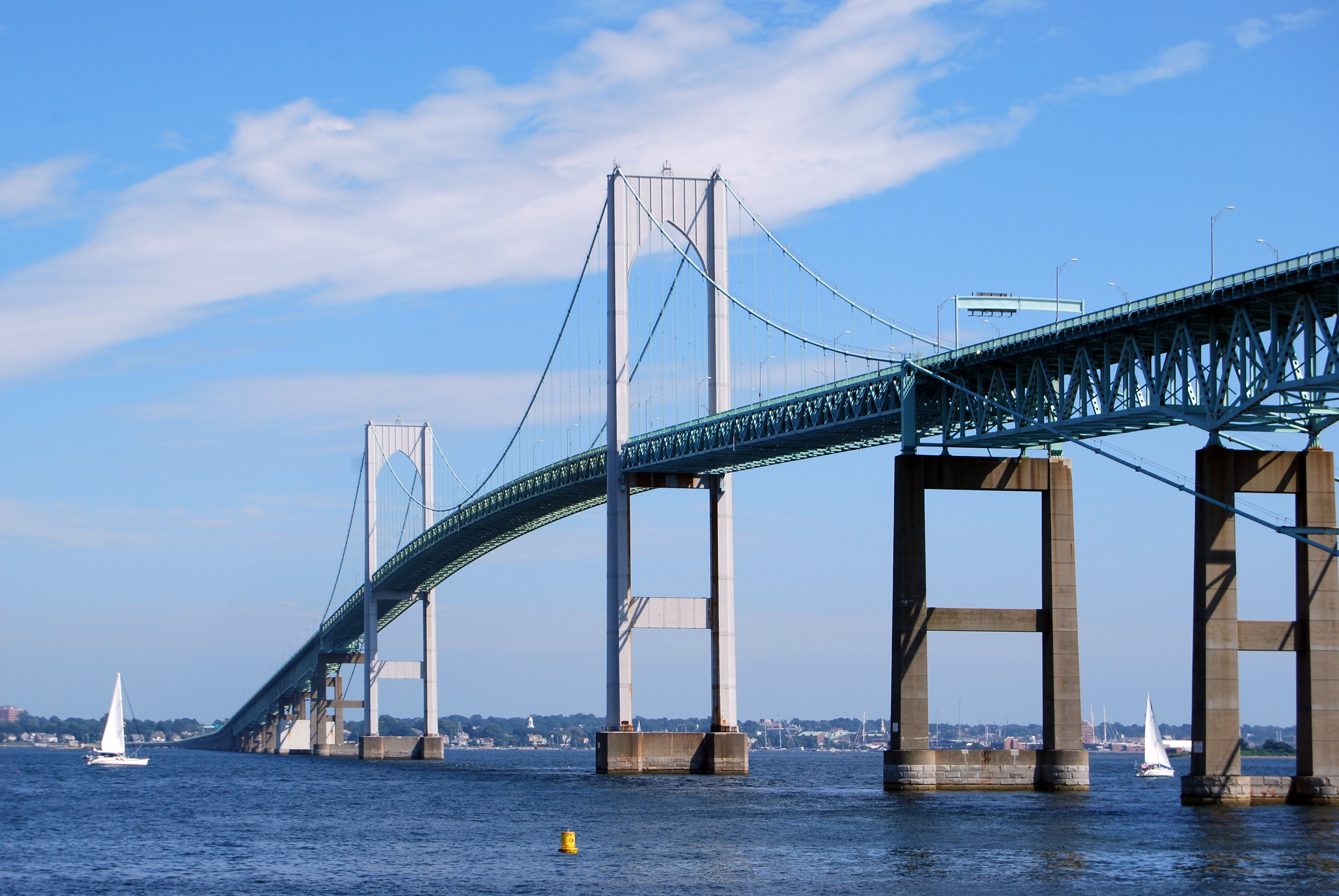 | |
|---|---|---|
| Major rivers | ||
| Cities & towns | ||
| Bridges |
| |
State of Rhode Island | |
|---|---|
Providence (capital) | |
| Topics |
|
| Society |
|
| Regions |
|
| Cities | |
| Towns |
|
Authority control | |
|---|---|
| General | |
| National libraries | |
| Other |
|
На других языках
[de] Tiverton (Rhode Island)
Tiverton ist eine Stadt (Town) im Newport County des US-Bundesstaates Rhode Island in den Vereinigten Staaten. Tiverton ist auch die Geburtsstadt des 1755 geborenen Seefahrers und ersten US-amerikanischen Weltumseglers Robert Gray.- [en] Tiverton, Rhode Island
Другой контент может иметь иную лицензию. Перед использованием материалов сайта WikiSort.org внимательно изучите правила лицензирования конкретных элементов наполнения сайта.
WikiSort.org - проект по пересортировке и дополнению контента Википедии