geo.wikisort.org - Island
Block Island is an island in the U.S. state of Rhode Island located in Block Island Sound approximately 9 miles (14 km) south of the mainland and 14 miles (23 km) east of Montauk Point, Long Island, New York, named after Dutch explorer Adriaen Block. It is part of Washington County and shares the same area as the town of New Shoreham. The Nature Conservancy added Block Island to its list of "The Last Great Places" which consists of 12 sites in the western hemisphere, and about 40 percent of the island is set aside for conservation.[1] It is part of the Outer Lands region, a coastal archipelago.
Block Island | |
|---|---|
Island | |
 Block Island looking North over Block Island Sound; the coast of Rhode Island is seen in the distance | |
| Nickname: Manisses meaning Manitou's Little Island (used by Narragansett people) | |
 Block Island, shown in red, off the coast of the State of Rhode Island | |
| Coordinates: 41°10′11″N 71°34′48″W | |
| Country | United States |
| State | Rhode Island |
| County | Washington |
| Town | New Shoreham |
| Government | |
| • Type | Council-manager |
| • First Warden | Ken Lacoste |
| Area | |
| • Land | 9.73 sq mi (25.2 km2) |
| Population (2020) | |
| • Total | 1,410 |
| Time zone | UTC−5 (EST) |
| • Summer (DST) | UTC−4 (EDT) |
| ZIP Code | 02807 |
| Area code | 401 |
| Website | www.new-shoreham.com |
| Historical population | |||
|---|---|---|---|
| Census | Pop. | %± | |
| 1970 | 489 | — | |
| 1980 | 620 | 26.8% | |
| 1990 | 836 | 34.8% | |
| 2000 | 1,010 | 20.8% | |
| 2010 | 1,051 | 4.1% | |
| 2020 | 1,410 | 34.2% | |
Block Island is a popular summer tourist destination and is known for its bicycling, hiking, sailing, fishing, and beaches. It is also the location of Block Island North Light on the northern tip of the island and Block Island Southeast Light on the southeastern side, both historic lighthouses. Much of the northwestern tip of the island is an undeveloped natural area and resting stop for birds along the Atlantic flyway.[2]
Popular events include the annual Fourth of July Parade, celebration, and fireworks. The island's population can triple over the normal summer vacation crowd. As of the 2020 Census, the island's population is 1,410 living on a land area of 9.734 square miles (25.211 km2).[3]
History
Before 1637
Block Island was formed by the same receding glaciers that formed the Outer Lands of Cape Cod, the Hamptons, Martha's Vineyard, and Nantucket during the end of the last ice age thousands of years ago.[4]

The Niantic people[5] called the island "Manisses" (meaning "Manitou's Little Island"),[6] or just "Little Island".[7][8] Archaeological sites indicate that these people lived largely by hunting deer, catching fish and shellfish, and growing corn, beans, and squash, presumably with the Three Sisters technique. They migrated from forest to coastal areas to take advantage of seasonal resources.[9] One modern researcher has theorized that indigenous groups may have established a settlement as early as 500 BC,[10] although there is no consensus on that idea.
Giovanni da Verrazzano sighted the island in 1524 and named it "Claudia" in honor of Claude, Duchess of Brittany, queen consort of France and the wife of Francis I. However, several contemporaneous maps identified the same island as "Luisa," after Louise of Savoy, the Queen Mother of France and the mother of Francis I. Verrazano's ship log stated that the island was "full of hilles, covered with trees, well-peopled for we saw fires all along the coaste." Almost 100 years later, Dutch explorer Adriaen Block charted the island in 1614; he simply named it for himself,[11] and this was the name that stuck.
Pequot War

The growing tensions among the tribes of the region in this time caused the Niantics to split into two divisions: the Western Niantics, who allied with the Pequots and Mohegans, and the Eastern Niantics, who allied with the Narragansetts.
In 1632, indigenous people (likely Western Niantics associated with the Pequots)[12] killed colonial traders John Stone and Walter Norton, and the Pequots of eastern Connecticut were blamed. A Pequot delegation presented magistrates in Boston with two bushels of wampum and a bundle of sticks representing the number of beavers and otters with which they would compensate the colonists for the deaths. They sought peace with the colonies and also requested help establishing concord with the Narragansetts, who bordered them to the east. The colonial authorities, in turn, demanded the people responsible for killing Stone and Norton, a promise not to interfere with colonial settlement in Connecticut, and 400 fathoms of wampum and the pelts of 40 beavers and 30 otters.[13][14]

In 1636, John Gallup came across the boat of trader John Oldham, a noted troublemaker. Oldham had flirted with impropriety since the day that he landed on American soil. Not long after arriving in Plymouth in 1623, he "grew very perverse and showed a spirit of great malignancy," according to Plymouth Colony Governor William Bradford. He was later accused of religious subversion and responded with impertinence, hurling invective at his accusers and even drawing a knife on Captain Myles Standish. He was banished from Plymouth and fled to Massachusetts Bay, settling first in Nantasket, then Cape Ann, and finally Watertown, where he continued to indulge his penchant for mayhem. Despite his unsavory reputation, Massachusetts Bay sought his extensive knowledge of the New England coast when they asked him to retrieve a hefty ransom on the colony's behalf. It was on this mission that Oldham was murdered and dismembered.[13][14]
In August, the Massachusetts authorities dispatched a punitive expedition of ninety men to Block Island under the command of John Endicott to avenge Oldham's murder. The expedition was ordered by governor of Massachusetts Sir Henry Vane to "massacre all of the Native men on the island" and capture the women and children, who would then be sold into slavery. Upon arriving on Block Island, the expedition burned sixty Niantic wigwams and all the cornfields on the island. The expedition also shot every dog they could find, though the Niantic fled into the woods and the colonists killed fourteen people. Deciding that this murder spree and razing was insufficient, Endicott and his men sailed over to Fort Saybrook before going after the Pequot village at the mouth of the Thames River to demand one thousand fathoms of wampum to pay for the murder. They took some Pequot children as hostages to ensure payment, with these incidents being seen as the initial events that led to the Pequot War.[15][16]
Settlement
Massachusetts Bay Colony claimed the island by conquest. In 1658, the colony sold the island to a group of men headed up by Endicott. In 1661, the Endicott group sold the island to a party of twelve settlers that later grew to sixteen (of whom only seven actually settled there[17]) led by John Alcock, who are today memorialized at Settler's Rock, near Cow's Cove. In 1663, island settler Thomas Terry gave six acres of land at the island's largest fresh pond and its surrounding area to four "chief sachems". Their names were recorded as Ninnecunshus, Jaguante, Tunkawatten, and Senatick, but they were known by the colonists as Mr. Willeam, Repleave (Reprive), and Soconosh. This land was given to "them being the Cheife Sachems upon the Island there Heires & Assignes Forever to plant and Improve".[18] This land was then known as the Indian Lands. The Sachems called the Fresh Pond Tonnotounknug.[19] In 1664, Indians on the island numbered somewhere from 1,200 to 1,500. By 1774, that number had been reduced to fifty-one.[20] A Dutch map of 1685 clearly shows Block Island, indicated as Adriaen Blocks Eylant ("Adrian Block's Island").
In the late seventeenth century, an Englishwoman called New England's first woman doctor lived on Block Island. Her name was Sarah Sands née Walker and she has also been suggested as a very early abolitionist.[21] She married sea captain James Sands (one of the original sixteen, as recorded by Settler's Rock[17]) in 1645 and had possibly six children, including a daughter named Mercy, born 1663. In 1699, Scottish sailor William Kidd visited Block Island, shortly before he was hanged for piracy. At Block Island, he was supplied by Mercy Sands (then Mrs. Raymond). The story has it that, for her hospitality, Kidd bade Mrs. Raymond to hold out her apron, into which he threw gold and jewels until it was full. After her husband Joshua Raymond died, Mercy moved with her family to what would become the Raymond-Bradford Homestead in northern New London, Connecticut (later Montville) where she bought much land. The Raymond family was thus said to have been "enriched by the apron".[22] Mercy Sands died at Lyme in 1741.[23][24]
Block Island was incorporated by the Rhode Island general assembly in 1672, and the island government adopted the name "New Shoreham."
Since Colonial times

During the War of 1812, the island was briefly occupied by the British Navy under the command of Sir Thomas Hardy. British vessels included HMS Dispatch, HMS Terror, HMS Nimrod, HMS Pactolus, and HMS Ramillies. Hardy took the fleet to Block Island in search of food and to establish a strategic position at the mouth of Long Island Sound. The British were enraged to discover that nearly all Block Island livestock and food stores had been transferred to Stonington, Connecticut in advance of their arrival. On August 9, 1814, Hardy and his fleet departed Block Island for Stonington Harbor in part to lay claim to the Block Island food stores and livestock. Hardy's pre-dawn raid on August 10 was repulsed with damage to his fleet in a battle that has since become known as the Battle of Stonington.[25]

The original North Lighthouse was built in 1829, but it was replaced in 1837 after the original was washed out to sea. The ocean claimed the replacement lighthouse also, and the lighthouse that can be seen today was constructed in 1867.[26] Construction began on Block Island's Southeast Lighthouse a few years later in 1873.
Block Island has no natural harbors; breakwaters were constructed in 1870 to form Old Harbor.


New Harbor was created in 1895 when a channel was dug to connect the Great Salt Pond to the ocean through the northwestern side of the island.
The Island Free Library was established in 1875 and is Block Island's only public library.
Isaac Church was the Island's last recorded full-blooded Manisses Indian; he died in 1886 at age 100. He was survived by one son and one daughter whose descendants still reside in Rhode Island today. The landmark Isaac's Corner is named in honor of him, located at the intersection of Center Road, Lakeside Drive, and Cooneymus Road. Isaac is buried to the east of the four corners in the Historical Indian Burial Ground. In 2011, the Block Island Historical Society dedicated the Block Island Manissean Ancestral Stone. In attendance at the unveiling ceremony were descendants of the Manisses Indians, with Tiondra White Rapids Martinez, a direct descendant of Isaac Church, opening the ceremony in their native tongue.[27]

During World War II, several artillery spotters were located on the island to direct fire from the heavy gun batteries at Fort Greene in Point Judith which protected the entrance to Narragansett Bay. Lookout positions for the spotters were built to look like houses. The US government offered to evacuate the island, as it could not be effectively defended from enemy invasion, but the islanders chose to stay. Days before the war ended against Germany, the Battle of Point Judith took place seven miles to the northeast of the island.
The island's airport (KBID) was opened in 1950 and remains open today as a general aviation airport.

In 1972, the Block Island Conservancy was founded. The Conservancy and other environmental organizations are responsible for protecting over 40% of the island from development.[28] In 1974, Old Harbor Historic District was declared a National Register historic district. More information can be found in the following books concerning Block Island's old buildings, islanders, history, and ongoing efforts to conserve the land, together with a collection of 800 period photographs of the island spanning the 1870s to the 1980s and all by historian Robert M. Downie:
- Block Island—The Sea
- Block Island—The Land
- The Block Island History of Photography, 2 volumes
Climate
| Block Island | ||||||||||||||||||||||||||||||||||||||||||||||||||||||||||||
|---|---|---|---|---|---|---|---|---|---|---|---|---|---|---|---|---|---|---|---|---|---|---|---|---|---|---|---|---|---|---|---|---|---|---|---|---|---|---|---|---|---|---|---|---|---|---|---|---|---|---|---|---|---|---|---|---|---|---|---|---|
| Climate chart (explanation) | ||||||||||||||||||||||||||||||||||||||||||||||||||||||||||||
| ||||||||||||||||||||||||||||||||||||||||||||||||||||||||||||
| ||||||||||||||||||||||||||||||||||||||||||||||||||||||||||||
Block Island's weather is greatly influenced by the surrounding ocean and prevailing winds that generally blow offshore. The climate is oceanic (Köppen Cfb), a rarity on an east coast island in the northern hemisphere. The climate borders on a humid continental (Dfa/b) or humid subtropical (Cfa) climate. The ocean stays cold during the spring and summer months, so Block Island stays cooler than the mainland during this period. July and August average in the mid- to upper-70s instead of low- to mid-80s that New York and southern New England experience. Block Island's record high temperature is 95 °F (35 °C) on August 26 and 27, 1948 and the record low is −11 °F (−24 °C) on January 16, 1994. The lowest high temperature on record was 8 °F (−13 °C) on December 31, 1962 and January 8, 1968, and the highest low temperature on record was 76 °F (24 °C) on August 2, 1979. Block Island stays warmer than the mainland during the fall and winter months when the ocean remains relatively warmer than the mainland. The hardiness zone is 7a.
| Climate data for New Shoreham, Rhode Island (1991–2020 normals, extremes 1948–present) | |||||||||||||
|---|---|---|---|---|---|---|---|---|---|---|---|---|---|
| Month | Jan | Feb | Mar | Apr | May | Jun | Jul | Aug | Sep | Oct | Nov | Dec | Year |
| Record high °F (°C) | 62 (17) |
62 (17) |
74 (23) |
92 (33) |
85 (29) |
90 (32) |
92 (33) |
95 (35) |
89 (32) |
80 (27) |
72 (22) |
64 (18) |
95 (35) |
| Average high °F (°C) | 38.5 (3.6) |
40.3 (4.6) |
45.6 (7.6) |
54.7 (12.6) |
64.1 (17.8) |
73.3 (22.9) |
78.8 (26.0) |
78.3 (25.7) |
72.3 (22.4) |
62.5 (16.9) |
53.4 (11.9) |
43.9 (6.6) |
58.8 (14.9) |
| Average low °F (°C) | 24.3 (−4.3) |
25.9 (−3.4) |
30.6 (−0.8) |
39.1 (3.9) |
47.6 (8.7) |
57.6 (14.2) |
63.3 (17.4) |
63.1 (17.3) |
56.7 (13.7) |
47.1 (8.4) |
39.2 (4.0) |
29.7 (−1.3) |
43.7 (6.5) |
| Record low °F (°C) | −11 (−24) |
−10 (−23) |
7 (−14) |
18 (−8) |
34 (1) |
41 (5) |
51 (11) |
45 (7) |
39 (4) |
28 (−2) |
16 (−9) |
−4 (−20) |
−11 (−24) |
| Average precipitation inches (mm) | 4.12 (105) |
3.61 (92) |
5.12 (130) |
3.89 (99) |
3.53 (90) |
3.78 (96) |
2.96 (75) |
4.20 (107) |
4.06 (103) |
4.77 (121) |
3.74 (95) |
4.62 (117) |
48.40 (1,229) |
| Average snowfall inches (cm) | 7.5 (19) |
7.9 (20) |
3.7 (9.4) |
0.8 (2.0) |
0 (0) |
0 (0) |
0 (0) |
0 (0) |
0 (0) |
0 (0) |
0.8 (2.0) |
5.7 (14) |
26.4 (67) |
| Average precipitation days (≥ 0.01 in) | 7.9 | 7.7 | 9.7 | 9.9 | 9.8 | 7.4 | 6.2 | 6.2 | 6.5 | 7.9 | 8.8 | 9.1 | 97.1 |
| Source: NOAA[29] | |||||||||||||
Arts and culture
Annual events
One of the most popular celebrations on the island is the Fourth of July Parade. Anybody can enter a float into the parade, as long as it coordinates with the theme of that respective year. For example, the theme in 2016 was sports and recreation. In addition to the parade, there is a fireworks display on the beach on the night of July 3. The parade is on the fourth and is judged by officials who give out prizes in three categories: family floats, company floats, and overall floats. They also give out one extra prize for the overall category which is the grand prize, consisting of $500.
Every summer, the island hosts Block Island Race Week, a competitive, week-long sailboat race. On odd years, the event is held by the Storm Trysail Club, and on even years by the Block Island Race Week. Yachts compete in various classes, sailing courses in Block Island Sound and circumnavigating the island.
Tourist attractions

Southeast Lighthouse is located at the southeast corner of the island on the Mohegan Trail. The lighthouse was constructed in 1875[30] and remains to this day an active US Coast Guard navigational aid.[26] The lighthouse was moved in 1993, in danger of falling off the bluffs due to erosion. In addition to offering tours of the tower, the lighthouse has a museum that is open during the summer season.[31]
The Mohegan Bluffs are located a short distance to the west of Southeast Lighthouse. The bluffs are the site of a pre-colonial battle between the invading Mohegan, and the native Niantic in which the Mohegan were driven off the edge of the tall cliffs to their deaths on the beach below. A staircase of 141 steps leads to the bottom of these clay cliffs and looks out over the Atlantic. On clear days, Montauk, New York can be seen in the distance from the southern and western sides of the island.

Rodman's Hollow is a 230-acre (93 ha) glacial outwash basin, near the southern shore of the island. The hollow has several walking trails.[32]
North Lighthouse is located at Sandy Point on the northern tip of Block Island. The North Lighthouse warns boaters of a sandbar extending from this end of the island. The surrounding dunes are part of the Block Island National Wildlife Refuge, home to many species, including the piping plover and American burying beetle.[33] A short walk away from the North Lighthouse lies the tip of the island, with ocean on both sides of a thin strip of land.
The Block Island Historical Society Museum is located near the downtown area and contains a broad array of Block Island artifacts.
U-853 is a U-boat wreck 7 miles (11 km) east of the island, lying in 130 ft (40 m) of water. Recreational divers frequently visit the wreck, though at least three have died there.[34][35]
The Block Island Wind Farm, the first offshore wind farm built in the United States, is located 3 miles (4.8 km) from south-east of the island.

[36][37][38][39] The five turbines, each 600 ft (180 m) high, commenced commercial operation in December 2016.[40]
The island has at least 40 restaurants, but most are closed outside of tourist season; mainland restaurants use New England Airlines to deliver food to the island.[41]
Parks and recreation


There are 17 miles of beach on Block Island. Crescent Beach can be viewed from the Pt. Judith Ferry and the New London Express Ferry on the way to the island. It contains five smaller beaches: Fred Benson Town Beach (popularly known as State Beach), Surf Beach, Scotch Beach, Rouse's Beach, and Mansion Beach, all of which are located on Corn Neck Road. North of Mansion Beach are Clayhead and Pots & Kettles. Clayhead is a set of cliffs which can be seen from the ferry in from Point Judith or New London. This area is rocky and contains iron-rich clay deposits, and is a popular area for shell and rock hunting.
Cow Cove, Settler's Rock, and Sandy Point make up the northernmost point of Block Island where the North Lighthouse is located. Settler's Rock is located at Cow Cove, where the settlers landed and swam to shore bringing with them the island's first cows, which they pushed off the boats and forced ashore. Attached to the rock is a plaque naming the original settlers of Block Island. Coastguard Beach (or "the channel") is situated between the Great Salt Pond and the ocean on the north west side of the island. Ballard's Beach is on the south side of the Block Island Ferry Dock and jetty. Bluffs Beach (or Vail) is set at the bottom of Mohegan Bluffs.
Block Island also hosts an office of The Nature Conservancy.[42] The Conservancy named Block Island as one of its top 12 sites in the Western Hemisphere, and a large portion of the island is legally protected and set aside for conservation.
Industry
The island is known for participating in the commercial aquaculture and kelp farming sectors.[43]
Transportation


The island is connected year-round by a ferry to Point Judith,[44] and in summer to New London, Connecticut; Orient and Montauk, New York; and Newport, Rhode Island, with the latter service also offering an extended route to Fall River, Massachusetts.[44] The traditional ferry takes about an hour to reach the island from Point Judith and is the only way to bring a car to the island as it is able to carry them. A high-speed ferry on the same route takes 35 minutes but cannot take cars, and another high-speed ferry from New London takes just over an hour.
Bikes are a popular form of transportation on the island, as cars are generally discouraged.
New England Airlines offers regularly scheduled 12-minute flights to Block Island State Airport from Westerly, Rhode Island.[41] The island airport is officially called Block Island State (code: BID) and the terminal is about one mile from the town center.
Incidents
Air crashes
On August 26, 1995, a Cessna 185 seaplane carrying four people crashed while attempting to land in the waters off Old Harbor Beach, an area not normally used for seaplane landings. The plane cleared a dune but hit a power line, causing it to crash into a restaurant and hit a car at the island's only gas station. All four people on the plane perished, as well as a woman who was sitting in her car as it was being fueled. The restaurant was destroyed by the impact of the plane and resulting fire.
On July 5, 2006, a plane carrying three people crashed ½ mile (800 m) west of the airport during bad weather. The aircraft had just taken off and was on its way to White Plains, New York.[45]
Shipwrecks
The area around Block Island has been the site of numerous shipwrecks, including the Steamer Larchmont in 1907.[46] The 1738 wreck of the Princess Augusta (also known as the Palatine ship) was later immortalized by John Greenleaf Whittier in his 1867 poem "The Wreck of the Palatine." In 1877, the freighter Achilles struck a submerged rock off the island and ran aground. In 1992, the Cunard liner Queen Elizabeth 2 struck a submerged rock.[47]
Two submarines also sank off Block Island: USS S-51 in 1925,[48] and German submarine U-853 in 1945.[49]
Notable people
- Kenneth Bacon (1944–2009), Department of Defense spokesman who served as president of Refugees International[50]
- Tad Devine (b. 1955), American political consultant. Senior adviser in Al Gore's 2000, John Kerry's 2004, and Bernie Sanders' 2016 presidential campaigns.[51]
- Elizabeth Dickens (1877–1963), "the Bird Lady of Block Island", writer, and naturalist[52]
- Richard Parsons (b. 1948), an American business executive, former chairman of Citigroup, and the former chairman and CEO of Time Warner.[53][54]
- Jens Risom (1916–2016), Danish-American furniture designer
- William Stringfellow (1928–1985), attorney and radical Anglican theologian
Gallery
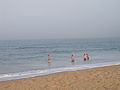 Swimmers in smooth waters at Block Island
 Settler's Rock is the most northerly part of Block Island accessible to motorists
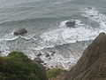 Steep bluffs at Block Island
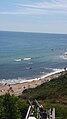 View of the Atlantic Ocean from a cliff on Block Island
 This house was formerly the US Weather Bureau Station on Block Island
 Long-finned Pilot Whales off southeast of Block Island


See also
- Block Island Wind Farm
- The Block Island Sound, 2020 film set and shot on Block Island
References
- "One of the last great places". Providence Journal. June 9, 2005. Retrieved 2007-10-01.
- "Block Island National Wildlife Refuge". United States Fish and Wildlife Service. Retrieved 2014-10-02.
- Census - Geography Profile: New Shoreham town, Washington County, Rhode Island United States Census Bureau
- History. "History". Blockislandinfo.com. Retrieved 2021-03-12.
- The Niantic people eventually merged with the Narragansett people.
- "Since Denali got its real name back, should Block Island be next?". 31 August 2015.
- "Block Island - island, Rhode Island, United States".
- Providence, RI : The Islands Archived 2010-04-10 at the Wayback Machine
- "The Pages of Shades : Native Americans". Archived from the original on 2010-09-26. Retrieved 2010-02-27.
- "The first winters: what archeologists have found".
- Rhode Island Office of the Secretary of State; Rhode Island Office of the Secretary of State; retrieved on October 23, 2007
- See Wm. Bradford, Of Plimouth Plantation and Mourt's Relation: A Journal of the Pilgrims at Plymouth
- "Pastore" (PDF). environmentsandsocieties.ucdavis.edu. 2011. Retrieved 2021-03-12.
- Pastore, Christopher. Between Land and Sea: Narragansett Bay and the Transformation of the New England Coast pp.1-5
- "History of the Mohegans". Niantic.
- Sawyer, Joseph Dillaway (1 January 1922). History of the Pilgrims and Puritans: Their Ancestry and Descendants; Basis of Americanization. Century History Company. pp. 18–25 – via Internet Archive.
manisees.
- Robert M. Downie (2011-11-16). "This Week in Block Island's history, November 8, 1660: A goat tale". Block Island Times. Retrieved 2021-03-12.
- [P.30 New Shoreham Town Book, No. 1, G. E. Burgess Transcription 1924.]
- [P. 21, New Shoreham Town Book, No. 1, G. E. Burgess Transcriotion 1924, Pp. 30-31]
- Zinn, Howard (4 February 2003). A People's History of the United States: 1492-Present. Harper Collins. p. 16. ISBN 9780060528423 – via Internet Archive.
peoples history of the united states.
- "Oddly enough, it was in reading an obscure and slender guidebook to". Archived from the original on 2018-11-04. Retrieved 2018-11-04.
- Caulkins, Frances Manwaring (1895). History of New London, Connecticut. p. 293.
- "Mercy Sands Raymond (1663-1741) - Find A Grave Memorial". Findagrave.com. Retrieved 2021-03-12.
- "Raymond-Bradford Homestead (1710) – Historic Buildings of Connecticut". Historicbuildingsct.com. 29 July 2014. Retrieved 2021-03-12.
- De Kay, Tertius (1990). The Battle of Stonington. p. 293.
- "Historic Light Station Information and Photography: Rhode Island". United States Coast Guard Historian's Office. Archived from the original on 2017-05-01. Retrieved October 23, 2007.
- Coni Dubois (30 June 2011). "Unveiling of Ancestral/Descendant Stone for the Block Island Indian's - Part 1". Archived from the original on 2021-12-12 – via YouTube.
- The Nature Conservancy in Rhode Island - Block Island Archived 2007-10-12 at the Wayback Machine; The Nature Conservancy; retrieved on October 30, 2007
- "NOAA NCEI U.S. Climate Normals Quick Access". National Oceanic and Atmospheric Administration. Retrieved 2021-11-21.
- Block Island South East Lighthouse National Historic Landmark Nomination; National Park Service Maritime Heritage Program; retrieved on October 23, 2007
- Daytripper's Guide: Block Island Archived October 13, 2007, at the Wayback Machine; University of Rhode Island Sea Grant; retrieved on October 22, 2007
- "Rodman's Hollow". nature.org. Archived from the original on 2007-10-10. Retrieved 2007-10-05.
- "Block Island National Wildlife Refuge". fws.gov. Retrieved 2007-10-05.
- Robert M. Downie (1998). Block Island—The Sea., page 194
- "Probe into scuba instructor death could take two months". cdnn.info. Retrieved 2007-07-23.
- "First Offshore Wind Farm In The U.S. Kicks Off Construction". ThinkProgress. Archived from the original on 8 July 2016. Retrieved 30 April 2015.
- "Clean energy is just over the horizon". Deepwater Wind. Retrieved 30 April 2015.
- "Block Island Wind Farm". Deepwater Wind. Retrieved 30 April 2015.
- Alex Kuffner Journal Staff Writer. "Deepwater Wind completes financing for Block Island wind farm". providencejournal.com. Retrieved 30 April 2015.
- Frangoul, Anmar (13 December 2016). "America's first offshore wind farm is up and running". CNBC.
- Passy, Charles (2015-08-26). "Meet the Pilot Who Doubles as Block Island's Chinese-Food Delivery Guy". The Wall Street Journal. pp. A1. Retrieved 26 August 2015.
- "Staff List for the Rhode Island Chapter's Block Island Office". The Nature Conservancy. Archived from the original on 2015-02-20. Retrieved February 19, 2015.
- "Why New England is going wild for wet weeds". The Economist. London, UK. 26 June 2021. Retrieved 28 June 2021.
- "Block Island Ferry Homepage". The Block Island Ferry.
- "New England Airlines". users.ids.net. Archived from the original on 2007-11-17. Retrieved 2007-12-12.
- "PROBABLY 150 LOST IN WRECK; Joy Line Steamer Larchmont Sunk; Only Nineteen Known Survivors. MANY DIED IN BOATS Scores, Lightly Clad, Faced Icy Gale -- Two Committed Suicide. SUNK BY A SCHOONER Coal-Laden Craft Rammed Its Bow Deep Into Steamer. CARE FOR WOMEN FIRST All Boats Launched Before Captain Left -- He Blames the Schooner's Men". 13 February 1907 – via NYTimes.com.
- British Admiralty. The Mariner's Handbook. 1999 edition, page 23.
- The Block Island Times[permanent dead link]; The Block Island Times; retrieved on October 30, 2007
- Shipwrecks - Northern Maritime Research - Northern Shipwrecks Database - Famous Shipwrecks of the Last 400 Years; Northern Maritime Research; retrieved on October 30, 2007
- Martin, Douglas (August 15, 2009). "K. H. Bacon, an Advocate For Refugees, Is Dead at 64". The New York Times. Retrieved August 16, 2009.
- Freedlander, David (15 February 2016). "Bernie's man behind the scenes: Tad Devine is the Karl Rove to Sanders' 2016 populist uprising". Salon.com. Retrieved 18 February 2016.
- Whitman, Herbert S. (1982). Elizabeth Dickens: The Bird Lady of Block Island. Still Pond Press.
- Bernard, Sarah (3 June 2002). "Travel: Summer 2002 Getaways: Block Island, Rhode Island". New York Magazine. Retrieved 18 February 2016.
- "Richard Parsons named CEO of Clippers". Block Island Times. 10 May 2015. Retrieved 18 February 2016.
External links
- Block Island.com
- Block Island Times Newspaper
- Block Island Chamber of Commerce
- Block Island Tourism Council
- Block Island Ferry
 Block_Island travel guide from Wikivoyage
- Ratification of the United States Constitution: New Shoreham from the Rhode Island State Archives
Municipalities and communities of Washington County, Rhode Island, United States | ||
|---|---|---|
County seat: South Kingstown | ||
| Towns |
|  |
| CDPs |
| |
| Other villages |
| |
| Indian reservation |
| |
| ||
State of Rhode Island | |
|---|---|
Providence (capital) | |
| Topics |
|
| Society |
|
| Regions |
|
| Cities | |
| Towns |
|
Authority control | |
|---|---|
| National libraries | |
| Other | |
На других языках
[de] Block Island (Rhode Island)
Block Island ist eine bewohnte Insel im Süden des US-Bundesstaates Rhode Island.- [en] Block Island
[fr] Block Island
Block Island est une île côtière du nord-est des États-Unis, 13 km au large l'État de Rhode Island dont elle fait partie. Elle est séparée du continent par le Block Island Sound. L'île a une superficie de 25,211 km2 pour une population de 1 010 habitants (recensement de 2000). Environ 20 % de l'île est en réserve naturelle. La seule ville de l'île est New Shoreham.[ru] Блок (остров)
Блок (англ. Block Island) — остров на границе проливов Лонг-Айленд и Блок-Айленд. Остров находится к югу от побережья штата Род-Айленд, к которому административно принадлежит, и северо-восточнее острова Лонг-Айленд.Другой контент может иметь иную лицензию. Перед использованием материалов сайта WikiSort.org внимательно изучите правила лицензирования конкретных элементов наполнения сайта.
WikiSort.org - проект по пересортировке и дополнению контента Википедии