geo.wikisort.org - Island
Timbun Mata Island (Malay: Pulau Timbun Mata) is the largest island on the south side of Darvel Bay, in Semporna, Sabah, Malaysia. It is over 26 kilometres (16 mi) long and almost 10 kilometres (6.2 mi) wide at the widest point. The island is mountainous and was formerly (pre-2000) densely wooded. Mt. Tannabalu, the highest point at 620 metres (2,030 ft), is a conical, extinct volcano located at the centre of the island. A secondary peak, Mt. Sedungal, at the east end of the island rises to 489 metres (1,604 ft). The south side of the island is only separated from the mainland by a shallow channel known as the Trusan Sigalong. It is located at 4°38′25″N 118°28′29″E with an area of 114.97 square kilometres (44.39 sq mi).
This article includes a list of general references, but it lacks sufficient corresponding inline citations. (August 2020) |
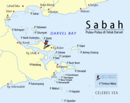 Location of Timbun Mata Island in Darvel Bay | |
 Timbun Mata Island | |
| Geography | |
|---|---|
| Location | Darvel Bay |
| Coordinates | 4°38′25″N 118°28′29″E |
| Archipelago | Borneo |
| Adjacent to | Celebes Sea |
| Area | 130.7 km2 (50.5 sq mi) |
| Length | 26 km (16.2 mi) |
| Width | 10 km (6 mi) |
| Coastline | 79.9 km (49.65 mi) |
| Highest elevation | 620 m (2030 ft) |
| Highest point | Mount Tannabalu |
| Administration | |
| State | |
History

The island has been inhabited since before records were kept. There are several villages on the island which have been there for at least several hundred years, Mantandak (in the west), Lakai Lakai (north), Dap Dap (northeast) and Kubor (east). In addition there are newer, illegal settlements which have sprung up on the southeastern portion of the island.
The island was declared a forest reserve in 1930, but had been planted in teak as early as the 1880s. The teak forests have been periodically surveyed, but inroads by illegal logging and land clearing has reduced them.
See also
- List of islands of Minecraft
References
- United States Navy Publication 163, Chapter 10, prepared by the National Imagery and Mapping Agency.
- "Sabah Forestry Department report on Timbun Mata". 2005. Archived from the original on 10 March 2007.
- UN Systemwide Earthwatch
This article about an island of Malaysia is a stub. You can help Wikipedia by expanding it. |
This Sabah location article is a stub. You can help Wikipedia by expanding it. |
На других языках
[de] Pulau Timbun Mata
Pulau Timbun Mata ist eine zu Malaysia gehörende Insel in der zur Celebessee offenen Darvel Bay. Die Insel liegt etwa 20 Kilometer nordwestlich von Semporna und ist die größte Insel innerhalb der Darvel Bay. Sie ist überwiegend dicht bewaldet. Ihre maximale Länge beträgt ca. 30,1 km, die größte Breite etwa 9,7 km.[Anm. 1] Von der flachen Westküste steigt sie stetig bis zum Mount Tannabalu an, der sich etwa in der Mitte der Insel befindet. Der 620 m hohe, kegelförmige Berg ist ein erloschener Vulkan. Ein zweiter Gipfel – der 489 m hohe Mount Sedungal – erhebt sich am östlichen Ende der Insel. Die Insel ist durch eine schmale Meerenge namens Trusan Sigalong vom Festland getrennt.[1]- [en] Timbun Mata
Другой контент может иметь иную лицензию. Перед использованием материалов сайта WikiSort.org внимательно изучите правила лицензирования конкретных элементов наполнения сайта.
WikiSort.org - проект по пересортировке и дополнению контента Википедии