geo.wikisort.org - Island
Jambongan Island (Malay: Pulau Jambongan) is located on the northern coast of Sabah in Malaysia. It is one of the largest island in Sabah located in Teluk Paitan (Paitan Bay) in the Sandakan Division. Jambongan town is located on the south-east of the island. The highest point on the island is Buli Gantungan Hill, at a height of 156 metres.[1]
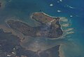 Jambongan Island seen from satellite

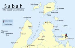 Location of Jambongan Island in Sulu Sea | |
 Jambongan Island | |
| Geography | |
|---|---|
| Coordinates | 6°41′0″N 117°25′0″E |
| Administration | |
| State | |
See also
References
- Sailing Directions (Enroute) - Borneo, Jawa, Sulawesi and NUsa Tenggara, United States Navy Publication 163, Sector 10 No. 10.67, 2002; accessed 6 February 2012
This article about an island of Malaysia is a stub. You can help Wikipedia by expanding it. |
This Sabah location article is a stub. You can help Wikipedia by expanding it. |
На других языках
[de] Pulau Jambongan
Pulau Jambongan (engl. Jambongan Island), manchmal auch Pulau Jembongan, ist eine zu Sabah, Malaysia gehörende Insel in der Sulusee. Sie bildet die östliche Begrenzung der Paitan Bay und die nördliche Begrenzung der Schomburgk Bay.- [en] Jambongan Island
Текст в блоке "Читать" взят с сайта "Википедия" и доступен по лицензии Creative Commons Attribution-ShareAlike; в отдельных случаях могут действовать дополнительные условия.
Другой контент может иметь иную лицензию. Перед использованием материалов сайта WikiSort.org внимательно изучите правила лицензирования конкретных элементов наполнения сайта.
Другой контент может иметь иную лицензию. Перед использованием материалов сайта WikiSort.org внимательно изучите правила лицензирования конкретных элементов наполнения сайта.
2019-2026
WikiSort.org - проект по пересортировке и дополнению контента Википедии
WikiSort.org - проект по пересортировке и дополнению контента Википедии