geo.wikisort.org - Island
The Stockholm Archipelago (Swedish: Stockholms skärgård) is the largest archipelago in Sweden, and the second-largest archipelago in the Baltic Sea (the largest being the Archipelago Sea across the Baltic in Finland). Part of the archipelago has been designated as a Ramsar site since 1989.[1]
This article has multiple issues. Please help improve it or discuss these issues on the talk page. (Learn how and when to remove these template messages)
|
Native name: Stockholms skärgård | |
|---|---|
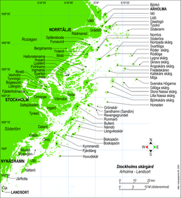 Map of Stockholm archipelago, covering the area from Arholma in the north to Landsort in the south | |
 Stockholm Archipelago | |
| Geography | |
| Location | Baltic Sea |
| Coordinates | 59.38778°N 18.73581°E |
| Total islands | ~24,000 |
| Major islands | Dalarö, Finnhamn, Nässlingen, Grinda, Husarö, Ingarö, Ljusterö, Möja, Nämdö, Rödlöga, Tynningö, Utö, Svartsö, Värmdö |
| Administration | |
Sweden | |
| County | Stockholm County |
Ramsar Wetland | |
| Official name | Svenska Högarna-Nassa |
| Designated | 12 June 1989 |
| Reference no. | 435[1] |
Water
The water has a pH value of 7.0 (neutral) or slightly lower, to be compared with approximately 8.0 for seawater. Together with humic substances this sometimes causes a bit brownish water colour, especially in the inner parts. The salinity varies between freshwater and brackish water with poor salinity. In the outer parts of the archipelago, the salinity reaches around 0.6–0.7 per cent by weight, to be compared with at least 1.5 for beginning to taste salty and around 3.0 or more for proper oceanic water. Sea ice is regularly formed in the inner parts every winter.[2]
Geography

The archipelago extends from Stockholm roughly 60 kilometres (37 miles) to the east. In a north–south direction, it mainly follows the coastline of the Södermanland and Uppland provinces, reaching roughly from Öja island, south of Nynäshamn, to Väddö, north of Norrtälje. It is separated from Åland by a stretch of water named South Kvarken. A separate group of islands lies further north, near the town of Öregrund. Between Arholma and Landsort there are approximately 24,000 islands and islets.[3] Some of the better-known islands are Dalarö, Finnhamn, Nässlingen, Grinda, Husarö, Ingarö, Ljusterö, Möja, Nämdö, Rödlöga, Tynningö, Utö, Svartsö and Värmdö.
The biggest towns of the archipelago, apart from Stockholm, are Nynäshamn, Vaxholm and Norrtälje. The village of Ytterby, famous among chemists for naming no fewer than four chemical elements (erbium, terbium, ytterbium and yttrium), is situated on Resarö in the Stockholm archipelago.
The shipping routes from the Baltic to Stockholm pass through the archipelago. There are three main entrances suitable for deep-draught craft, namely, those near Landsort, Sandhamn, and Söderarm.
History

The Stockholm archipelago is a joint valley landscape that has been shaped – and is still being shaped – by post-glacial rebound.[4][5] It was not until the Viking Age that the archipelago began to assume its present-day contours. The islands rise by about three millimeters each year. In 1719 the archipelago had an estimated population of 2,900, consisting mostly of fishermen. Today the archipelago is a popular holiday destination with some 50,000 holiday cottages (owned mainly by Stockholmers). The Stockholm Archipelago Foundation, dedicated to the preservation of the nature and culture of the archipelago, owns some 15% of its total area.
The inhabitants in the archipelago, from around the mid-1400s to the end of the second world war, were combined farmers and fishermen. Spring and autumn fishing was quite intensive in the outer archipelago from 1450 until the mid-1800s, and many fishermen lived for long periods in the outer islands because of the long distances to their permanent houses in the inner archipelago. The combined farming and fishing culture lasted until around 1950–1955 when the younger generation, born during and directly after the war, started to leave the archipelago and look for jobs in the cities on the mainland. Today most of the small farms on the islands are closed and the fishing industry has almost disappeared.
Culture
Many poets, authors and artists have been influenced and fascinated by the Stockholm archipelago. Among them are August Strindberg, Ture Nerman, Roland Svensson, Ernst Didring and Aleister Crowley. Björn Ulvaeus and Benny Andersson from the group ABBA wrote most of their songs in a cabin located on the archipelago.
Boating is an extremely popular activity with the sailing race Ornö runt (or Around the island of Ornö) being the largest in the archipelago. This annual race, organised by the Tyresö Boat Club, has taken place every year since 1973. It is open to anyone with a sailing boat but requires registration. There are different entry classes, with the family class being the least competitive.
In the winter skaters make excursions over the ice.
Travel
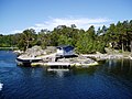
Visiting the larger islands in the archipelago is easy all year round, but during winter period the routes depend on the ice conditions. Several companies have regular routes. The largest ship owner company is Waxholmsbolaget owned by the Stockholm County government. Taxi boats are also available. In summer the archipelago bristles with private boats filled with people who often take advantage of Allemansrätt (or "everyman's right"), a law which gives anyone the right to go ashore or anchor on any ground not in the direct vicinity of buildings.
Image gallery
 Pier 'Gällnönäs'
 Natural harbour at the island 'Sprickopp', 'Lilla Nassa' archipelago
 Natural harbour at the island 'Svenska Högarna'
 Maritime pilot station at 'Landsort'
 The lighthouse and buildings at the island 'Huvudskär'
 Sandhamn island
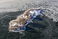 Bastugrundet in ice
 The island of Norra Stavsudda
 Islands in the Archipelago as seen from Björnö nature reserve.


See also
References
- Stockholm archipelago approximately 24,000 islands and islets; ref Bertil Hedenstierna: "Skärgårdsöar och fiskekobbar", Rabén&Sjögren, 1989, part 1 (p. 10).
Notes
- "Svenska Högarna-Nassa". Ramsar Sites Information Service. Retrieved 16 July 2019.
- https://www.havet.nu
- "Swedish islands" (PDF). SCB, The Swedish Statistics Agency. Retrieved 18 March 2011.
- Lidmar-Bergströrm, Karna (1995). "Relief and saprolites through time on the Baltic Shield". Geomorphology. Elsevier. 12 (1): 45–61. Bibcode:1995Geomo..12...45L. doi:10.1016/0169-555X(94)00076-4.
- Sporrong, Ulf (2003). "The Scandinavian landscape and its resources". In Helle, Knut (ed.). The Cambridge History of Scandinavia. Cambridge University Press. p. 37.
Reference nautical chart
Further reading
- Jeppe Wikström, title Havsskärgård, 2004. Mainly images from the outer parts of Stockholm archipelago. ISBN 91-89204-80-8
External links
На других языках
[de] Stockholmer Schärengarten
Der Stockholmer Schärengarten (schwedisch Stockholms skärgård) ist ein Schärengarten in der Ostsee, östlich von Stockholm. Er ist die größte Inselgruppe in Schweden und die zweitgrößte Inselgruppe der Ostsee nach dem Schärenmeer, das zu Finnland gehört.- [en] Stockholm Archipelago
[es] Archipiélago de Estocolmo
El archipiélago de Estocolmo (en sueco, Stockholms skärgård) es el más grande de Suecia y uno de los más grande del mar Báltico.[fr] Archipel de Stockholm
L’archipel de Stockholm (en suédois Stockholms skärgård) est le plus vaste archipel de Suède, et l'un des plus importants de toute la mer Baltique. Il s'étend sur une soixantaine de kilomètres à l'est de Stockholm, jusqu'aux îles d'Åland, et sur près de 120 kilomètres le long de la côte est de la Suède. Il est composé de quelque 24 000 îles de toutes tailles[1].[it] Arcipelago di Stoccolma
L'arcipelago di Stoccolma (in svedese: Stockholms skärgård) è il più grande arcipelago della Svezia ed uno dei maggiori del Mar Baltico. Si estende da Stoccolma per circa 60 km verso est. Consiste di circa 24.000 isole di varie dimensioni e segue approssimativamente la morfologia della costa delle province di Södermanland e Uppland (o Uplandia). Gran parte delle isole sono disabitate[1].[ru] Стокгольмский архипелаг
Стокгольмский архипелаг (швед. Stockholms skärgård) — крупнейший архипелаг в Швеции и один из крупнейших в Балтийском море.Другой контент может иметь иную лицензию. Перед использованием материалов сайта WikiSort.org внимательно изучите правила лицензирования конкретных элементов наполнения сайта.
WikiSort.org - проект по пересортировке и дополнению контента Википедии