geo.wikisort.org - Island
Sirri Island (Persian: جزیره سیری), is an island in the Persian Gulf belonging to Iran.
 | |
| Location | Sirri Island, Iran |
|---|---|
| Coordinates | 25°54′19″N 54°33′05″E |
| Tower | |
| Foundation | concrete base |
| Construction | metal skeletal tower |
| Height | 20 m (66 ft) |
| Shape | square pyramidal skeletal tower[1][2] |
| Light | |
| Focal height | 30 m (98 ft) |
| Range | 10 nmi (19 km; 12 mi) |
| Characteristic | Fl(3) W 15s |
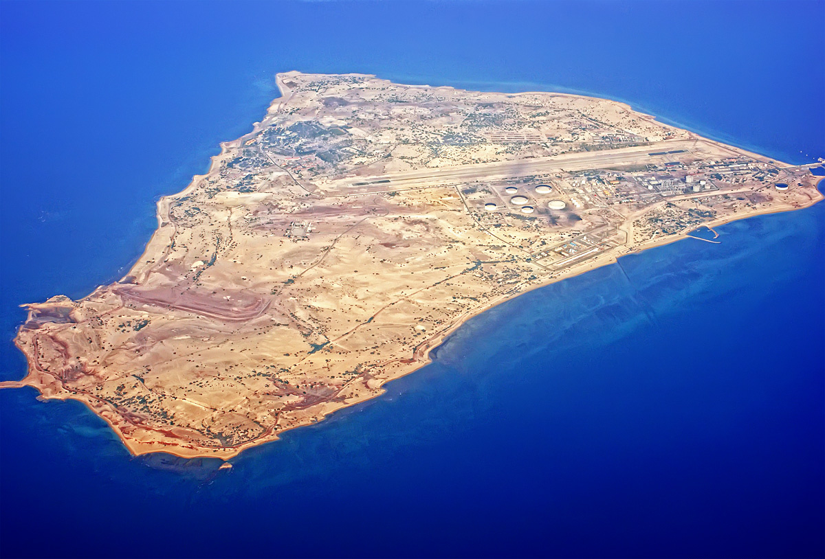
Sirri island (also known as Siri Island) is situated 76 kilometres (47 mi) from Bandar-e Lengeh and 50 kilometres (31 mi) west of Abu Musa island. The island is one of six in the Abu Musâ Island Group (and is part of Hormozgan province). The island is almost 5.6 kilometres (3.5 mi) long with a width of about 3 kilometres (1.9 mi). It covers an area of 17.33 square kilometres (6.7 square miles). The highest point on the island is 33 metres (108 feet) above sea level. Like the other islands in the Persian Gulf it enjoys a warm and humid climate.
Sirri Island is the location of an oil platform that was once destroyed by the naval forces of the United States during Operation Praying Mantis on April 18, 1988. The platform was reconstructed later, after the war. The Sirri District includes the Sivand and Dena Oil Fields, Nosrat Oil Field, Alvand Oil Field and the Esfand Oil Field along with the Nasr offshore oil platforms. The airport located on the island (Sirri Airport (SXI)) is uncontrolled with a single 8,140-foot (2,480 m) runway though Iranian military planes have been seen there.
The Iranian Offshore Oil Company (IOOC) has undertaken several major oil and gas development projects on the island including a $500 million (USD) NGL Gas factory and a development contract to develop and increase production of the Iranian Nosrat oil field which is projected to increase crude oil production capacity from 5,000 to 16,000 barrels per day (790 to 2,540 cubic metres per day). Another project plans for the renovation of the crude oil export facilities and construction of two large crude oil storage tanks, each with 500,000 barrels (79,000 m3) capacity, on the island is also planned.[3]
Climate
Sirri Island has a hot desert climate (Köppen climate classification BWh).
In the summer, Sirri Island sees some of the highest average dew points of any place in the world, averaging above 28 °C (82 °F) in July and August. As a result, heat indices generally top 50 °C (122 °F) for most days during the summer.[4] This immense humidity causes summer diurnal ranges to be lower than in normal desert climates, and is a result of air flow from the warm waters of the Persian Gulf.
| Climate data for Jazireh Siri (1983–2010) | |||||||||||||
|---|---|---|---|---|---|---|---|---|---|---|---|---|---|
| Month | Jan | Feb | Mar | Apr | May | Jun | Jul | Aug | Sep | Oct | Nov | Dec | Year |
| Record high °C (°F) | 28.0 (82.4) |
30.6 (87.1) |
32.0 (89.6) |
37.6 (99.7) |
41.4 (106.5) |
41.2 (106.2) |
40.5 (104.9) |
41.6 (106.9) |
40.6 (105.1) |
42.6 (108.7) |
34.8 (94.6) |
30.8 (87.4) |
42.6 (108.7) |
| Average high °C (°F) | 23.1 (73.6) |
23.4 (74.1) |
25.1 (77.2) |
29.1 (84.4) |
33.4 (92.1) |
34.7 (94.5) |
35.8 (96.4) |
36.2 (97.2) |
35.2 (95.4) |
33.3 (91.9) |
29.8 (85.6) |
25.4 (77.7) |
30.4 (86.7) |
| Daily mean °C (°F) | 20.5 (68.9) |
20.9 (69.6) |
22.6 (72.7) |
26.1 (79.0) |
30.1 (86.2) |
31.9 (89.4) |
33.4 (92.1) |
33.9 (93.0) |
32.7 (90.9) |
30.5 (86.9) |
27.0 (80.6) |
22.9 (73.2) |
27.7 (81.9) |
| Average low °C (°F) | 17.9 (64.2) |
18.5 (65.3) |
20.1 (68.2) |
23.1 (73.6) |
26.9 (80.4) |
29.0 (84.2) |
31.0 (87.8) |
31.6 (88.9) |
30.2 (86.4) |
27.7 (81.9) |
24.2 (75.6) |
20.4 (68.7) |
25.1 (77.2) |
| Record low °C (°F) | 9.4 (48.9) |
13.0 (55.4) |
13.6 (56.5) |
17.0 (62.6) |
20.0 (68.0) |
25.0 (77.0) |
26.6 (79.9) |
28.4 (83.1) |
25.0 (77.0) |
20.0 (68.0) |
16.0 (60.8) |
13.6 (56.5) |
9.4 (48.9) |
| Average precipitation mm (inches) | 24.9 (0.98) |
14.9 (0.59) |
27.0 (1.06) |
3.8 (0.15) |
0.2 (0.01) |
0.0 (0.0) |
0.4 (0.02) |
0.6 (0.02) |
0.0 (0.0) |
1.3 (0.05) |
7.5 (0.30) |
32.6 (1.28) |
113.2 (4.46) |
| Average precipitation days (≥ 1.0 mm) | 2.7 | 1.6 | 2.8 | 0.7 | 0.1 | 0.0 | 0.0 | 0.0 | 0.0 | 0.1 | 0.7 | 2.8 | 11.5 |
| Average relative humidity (%) | 62 | 66 | 70 | 69 | 67 | 73 | 74 | 72 | 70 | 63 | 59 | 62 | 67 |
| Mean monthly sunshine hours | 228.8 | 227.0 | 232.3 | 268.4 | 318.2 | 326.0 | 291.6 | 294.6 | 282.2 | 298.2 | 262.3 | 224.4 | 3,254 |
| Source: Iran Meteorological Organization (records),[5] (temperatures),[6] (precipitation),[7] (humidity),[8] (days with precipitation),[9]
(sunshine)[10] | |||||||||||||
See also
- List of lighthouses in Iran
- List of islands of Iran
- Hormozgān
References
- Rowlett, Russ. "Lighthouses of Iran". The Lighthouse Directory. University of North Carolina at Chapel Hill. Retrieved 2016-10-03.
- NGA List of Lights – Pub.112 Retrieved 3 October 2016
- "Siri Island projects". IOOC.
- "Archived copy". www.chbmet.ir. Archived from the original on 5 May 2016. Retrieved 13 January 2022.
{{cite web}}: CS1 maint: archived copy as title (link) -
- "Highest record temperature in Jazireh Siri by Month 1983–2010". Iran Meteorological Organization. Retrieved April 8, 2015.
- "Lowest record temperature in Jazireh Siri by Month 1983–2010". Iran Meteorological Organization. Retrieved April 8, 2015.
-
- "Average Maximum temperature in Jazireh Siri by Month 1983–2010". Iran Meteorological Organization. Archived from the original on March 6, 2016. Retrieved April 8, 2015.
{{cite web}}: CS1 maint: bot: original URL status unknown (link) - "Average Mean Daily temperature in Jazireh Siri by Month 1983–2010". Iran Meteorological Organization. Retrieved April 8, 2015.
- "Average Minimum temperature in Jazireh Siri by Month 1983–2010". Iran Meteorological Organization. Archived from the original on March 6, 2016. Retrieved April 8, 2015.
{{cite web}}: CS1 maint: bot: original URL status unknown (link)
- "Average Maximum temperature in Jazireh Siri by Month 1983–2010". Iran Meteorological Organization. Archived from the original on March 6, 2016. Retrieved April 8, 2015.
- "Monthly Total Precipitation in Jazireh Siri by Month 1983–2010". Iran Meteorological Organization. Retrieved April 8, 2015.
-
"Average relative humidity in Jazireh Siri by Month 1983–2010". Iran Meteorological Organization. Archived from the original on March 6, 2016. Retrieved April 8, 2015.
{{cite web}}: CS1 maint: bot: original URL status unknown (link) -
"No. Of days with precipitation equal to or greater than 1 mm in Jazireh Siri by Month 1983–2010". Iran Meteorological Organization. Archived from the original on March 6, 2016. Retrieved April 8, 2015.
{{cite web}}: CS1 maint: bot: original URL status unknown (link) -
"Monthly total sunshine hours in Jazireh Siri by Month 1983–2010". Iran Meteorological Organization. Archived from the original on March 6, 2016. Retrieved April 8, 2015.
{{cite web}}: CS1 maint: bot: original URL status unknown (link)
Iranian islands in the Persian Gulf | ||
|---|---|---|
| ||
| Capital |
|  | |||||||||||||||||||||||
|---|---|---|---|---|---|---|---|---|---|---|---|---|---|---|---|---|---|---|---|---|---|---|---|---|---|
| Counties and cities |
| ||||||||||||||||||||||||
| Sights |
| ||||||||||||||||||||||||
| populated places |
| ||||||||||||||||||||||||
| See also | |||||||||||||||||||||||||
Authority control | |||
|---|---|---|---|
| General |
| ||
| National libraries | |||
| Additional |
| ||
This Hormozgan province location article is a stub. You can help Wikipedia by expanding it. |
На других языках
- [en] Sirri Island
[fr] Sirri
L'île Sirri (persan: سیری) est une île d'Iran située dans le golfe Persique. Elle se trouve à 50 km au nord-ouest de l'île Abu Moussa et à 76 km au sud de Bandar-e Lengeh, sur la côte iranienne.[it] Sirri (isola)
L'isola di Siri o Sirri (in persiano: جزیره سیری) si trova nel Golfo Persico 25°54′N 54°32′E e fa parte delle 6 isole dell'arcipelago di Abu Musa (Abu Musa, Bani Forur, Forur, Sirri, Grande e Piccola Tunb). Appartiene all'Iran, provincia di Hormozgan. Si trova 76 km al largo di Bandar Lengeh e 50 km a ovest di Abu Musa.[ru] Сирри
Сирри́[1] (перс. جزیره سیری) — иранский остров, располагающийся в Персидском заливе, немного выше и западнее острова Абу-Муса. Он имеет форму трапеции. Площадь острова составляет 17 км².Другой контент может иметь иную лицензию. Перед использованием материалов сайта WikiSort.org внимательно изучите правила лицензирования конкретных элементов наполнения сайта.
WikiSort.org - проект по пересортировке и дополнению контента Википедии