geo.wikisort.org - Island
Kharg or Khark Island (Persian: جزیره خارک) is a continental island in the Persian Gulf belonging to Iran. The island is located 25 km (16 mi) off the coast of Iran and 483 km (300 mi) northwest of the Strait of Hormuz. Its total area is 20 km2 (7.7 sq mi). Administered by the adjacent coastal Bushehr Province, Khark Island provides a sea port for the export of oil and extends Iranian territorial sea claims into the Persian Gulf oil fields. Located on Khark Island is Khark, the only city in the Khark District.
Native name: جزیره خارک | |
|---|---|
 | |
 Khark Island | |
| Geography | |
| Location | Persian Gulf |
| Coordinates | 29°14′42″N 50°18′36″E |
| Administration | |
Iran | |
History
![As of 2012[update], the Khark oil terminal handled about 98% of Iran's crude exports (1967 photo).[citation needed]](http://upload.wikimedia.org/wikipedia/commons/2/21/Kharg_oil_loading_terminal.jpg)
Mentioned in the Hudud al-'Alam as a good source for pearls around 982 AD, Khark was visited by the French traveller Jean de Thévenot in 1665, who recorded trade at the time with Isfahan and Basra.[1] In 1753 the Dutch Empire established both a trading post and a fort on the island after securing perpetual ownership of the island from Mir Nasáir, the Arab ruler of Bandar Rig, in return for a present of 2000 rupees.[2] In 1766 the Dutch fort was captured by Mir Mahanna, the governor of Bandar Rig.[3]
The island was briefly occupied in 1838 by the British to block the Siege of Herat (1838) but was soon returned. Amoco built and operated the oil terminal on the island. Its property was expropriated after the revolution.

Once the world's largest offshore crude oil terminal and the principal sea terminal for Iranian oil, the Khark Island facilities were put out of commission in the fall of 1986. Heavy bombing of the Khark Island facilities from 1980 through 1988 by the Iraqi Air Force during the Iran–Iraq War all but destroyed most of the terminal facilities. Khark Island was situated in the middle of the Darius Oilfield, also destroyed by the intensive bombing. Repair to all facilities has been very slow, even after the war ended in 1988. The events experienced by this island gave rise to the dispute in the English contract law case The Kanchenjunga [1990] 1 Lloyd's Rep 391, regarding the conditions for repudiatory breach of contract and a claimant's right to elect to accept repudiation.
In 2009, Iran exported and swapped 950 million barrels of crude oil via southern Khark oil terminal.[4]
Archaeology
 | |
 Shown within Iran | |
| Location | 25 km (16 mi) off the coast of Iran |
|---|---|
| Coordinates | 29.235481°N 50.31°E |
| History | |
| Periods | Selucid, Parthian, Nabataean |
| Site notes | |
| Archaeologists | F. Sarre, E. Herzfeld, Marie-Joseph Steve |
| Condition | ruins |
| Public access | Yes |
 | |
| Location | Kharg Island, Iran |
|---|---|
| Coordinates | 29°12′51″N 50°19′10″E |
| Tower | |
| Foundation | concrete base |
| Construction | aluminium skeletal tower |
| Height | 14 m (46 ft) |
| Shape | square pyramidal tower with central cylinder and lantern[5][6] |
| Light | |
| Focal height | 90 m (300 ft) |
| Range | 17 nmi (31 km; 20 mi) |
| Characteristic | Fl(2) W 12s |
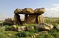
The first archaeological evidence of human occupation on Khark island was reported by Captain A. W. Stiffe in 1898, with studies published about his discoveries by F. Sarre and E. Herzfeld in 1910. They discovered two rock-cut chambered tombs featuring arched entranceways to a main chamber with vestibule from which spawned around twenty smaller chambers. The southern tomb is 13 m (43 ft) deep and features a relief of a reclining man drinking in the Seleucid and Parthian styles of Palmyra along with a damaged relief suggested to feature Nike on the face of a sphere-topped column. Mary-Joseph Steve has argued that the architecture of the tombs is more reminiscent of Nabataean architecture at Petra than anything Palmyrene.[7][8][9][10][11]
Another eighty three rock cut tombs and sixty two megalithic tombs have been studied on Kharg. The rock-cut tombs fall into four categories; single chambered, shallow tombs of varying shape, pit burials and excavated multi-chambered complexes. Steve also noticed the presence of several Nestorian style crosses at some of the tombs.[9]
There are also ruins of a coarse stone temple on the island measuring around 7.5 m (25 ft) square with a plastered altar for fire in the centre.[1]
A Christian church complex or ancient monastery of some 96 m (315 ft) by 85 m (279 ft) is also located on the island featuring a chapel, nineteen monks cells, library and courtyard.[1]
Achaemenid inscription
On November 14, 2007, a cuneiform inscription dating back to Achaemenid era was discovered on Kharg Island in Old Persian. The inscription is carved on a coral rock in Old Persian semi-syllabic cuneiform signs. Despite the usually well-ordered regular system of Achaemenid inscriptions, this one is in an unusual order written in five lines.[12]
Translation
“The not irrigated land was happy [with] my bringing out [of water]”[13]
The linguist Habib Borjian explains that if the inscription is authentic, combined with the island's known history of kariz usage, "which came about under the Achaemenid rule in the Near East (550–330 BCE)", it can be suggested that there was a Persian colonisation of Kharg under the Achaemenids.[13] The Iranian dialect of the Persian settlers of the Achaemenid period may have in turn been the ancestor of the Khargi language, with Borjian adding that "there is no contradicting evidence to make this hypothesis implausible".[13]
On May 31, 2008, the inscription was seriously damaged by unknown vandal(s). They destroyed it with a sharp object, such that about 70 percent of the inscription was seriously damaged. The nature of the damage indicates that it was done deliberately.[14]
The 17th-century French traveller Jean de Thévenot noted the presence of qanat (i.e. kariz) on the island that would have provided ancient irrigation.[1]
In popular culture
The island appears with a SAM radar installation on it in the Sega Genesis flight simulator F-15 Strike Eagle II in the Persian Gulf mission map.
The island is featured as a playable map in DICE's Battlefield 3 video game,[15] having some resemblance to the real island.
It also appears in Delta Force: Black Hawk Down – Team Sabre.
See also
- List of lighthouses in Iran
References
- Potts, D.T. (2004). "KHARG ISLAND ii. History and archeology". In Yarshater, Ehsan (ed.). Encyclopædia Iranica, Online Edition. Encyclopædia Iranica Foundation.
- J. R. Perry, "The Banu Ka'b: An amphibious brigand state in Khuzistan," Le monde iranien et l'Islam 1, 1971, pp. 131-52. Idem, "Mir Muhanna and the Dutch: Patterns of piracy in the Persian Gulf," Stud. Ir. 2, 1973, p85.
- Abdullah, Thabit (2001). Merchants, Mamluks, and murder: the political economy of trade in eighteenth century Basra. Albany: State University of New York Press. ISBN 978-0-7914-4808-3. Retrieved 3 March 2011.
- "Khark Oil Exports". Iran Daily. 2009. Archived from the original on May 22, 2009. Retrieved 3 March 2011.
{{cite news}}: CS1 maint: unfit URL (link) - Rowlett, Russ. "Lighthouses of Iran". The Lighthouse Directory. University of North Carolina at Chapel Hill. Retrieved 2016-10-03.
- NGA List of Lights – Pub.112 Retrieved 3 October 2016
- Stiffe, Captain A. W., "Persian Gulf notes. Kharag island," Geographical Journal 12, 1898, pp. 179-82. Sykes, P.M., A History of Persia, vol. 2, London, 1915.
- F. Sarre and E. Herzfeld, Iranische Felsreliefs, Berlin, 1910.
- Steve, M.-J., "Sur l'île de Khârg dans le golfe Persique," Dossiers d'Arche‚ologie 243, pp. 74-80, 1999.
- Steve, M.-J., et al. L'ille de Kharg. Une page de l'histoire du Golfe Persique et du monachisme oriental. Civilisations du Proche-Orient, Gent, Serie I, Archeologie et Environnement, (Forthcoming)
- Haerinck, E., "Quelques monuments fune‚raires de l'île de Kharg dans le Golfe Persique," Iranica Antiqua 11, 1975, pp. 144-67. Idem, "More pre-Islamic coins from southeastern Arabia," Arabian Archaeology and Epigraphy 9, 1998, pp. 278-301. Handbuch des Persischen Golfs, 5th ed., Hamburg, Deutsches Hydrographisches Institut, 1976.
- "Newly Found Old-Persian Cuneiform Inscription of Kharg Island Deciphered". Iranian Cultural Heritage News Agency. 8 December 2007. Archived from the original on 29 September 2011. Retrieved 3 March 2011.
- Borjian, Habib (2019). "The Language of the Kharg Island". Journal of the Royal Asiatic Society. 29 (4): 680. doi:10.1017/S1356186319000403. S2CID 213053987.
- "Khark island's Achaemenid inscription seriously damaged". Payvand News. 1 June 2008. Retrieved 3 March 2011.
- "Battlefield 3 Maps". Electronic Arts. 2011. Archived from the original on 15 October 2011. Retrieved 15 October 2011.
| Capital | 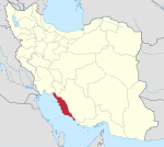 | ||||||||||||||||||||
|---|---|---|---|---|---|---|---|---|---|---|---|---|---|---|---|---|---|---|---|---|---|
| Counties and cities |
| ||||||||||||||||||||
| Landmarks |
| ||||||||||||||||||||
| populated places |
| ||||||||||||||||||||
Iranian islands in the Persian Gulf | ||
|---|---|---|
| ||
Middle Eastern megaliths | ||
|---|---|---|
| Lebanon |
|  |
| Syria |
| |
| Saudi Arabia |
| |
| Israel |
| |
| Jordan |
| |
| Turkey |
| |
| Egypt |
| |
| Iran | ||
| Iraq |
| |
| General articles |
| |
На других языках
[de] Charg
Charg (englisch Kharg; persisch خارگ, DMG Ḫārg, auch خارک, DMG Ḫārk) ist eine bewohnte Insel im Persischen Golf. Sie gehört zum Iran, liegt etwa 30 Kilometer vor der Küste des Festlands und ist rund 6 km lang und 4 km breit, die Einwohnerzahl beträgt etwa 10.000. Die Insel liegt 55 km westlich von Buschehr und 35 km südlich von Ganaveh.- [en] Kharg Island
[fr] Kharg
Kharg ou Khark (en persan : جزیره خارک, Jazireh Khark) est une île du golfe Persique appartenant à l'Iran. Elle est située à 25 km (13,5 milles) de la côte de l'Iran et à 483 km au nord du détroit d’Ormuz. Administrée par la Province de Bushehr adjacente, l'île étend les eaux territoriales iraniennes vers les gisements pétroliers du golfe Persique. L'île de Kharg possède un port permettant d'exporter le pétrole.[it] Khark
L'isola di Khārk o Khārg (farsi جزیره خارک Jazīreh-ye Khark) è una circoscrizione dello shahrestān di Bushehr, nella provincia di Bushehr. L'isola si trova a 25 km dalla costa iraniana e 483 km a nord-ovest dello stretto di Hormuz. Il suo porto è un importante centro di esportazione di greggio. Il termine khark in persiano significa "dattero ancora acerbo".[ru] Харк (остров)
Харк[1] (Джезирейе-Харк[2], перс. جزیره خارگ) — иранский остров в Персидском заливе, расположенный на расстоянии 25 километров от побережья Ирана и на расстоянии 57 километров от города Бушир. Относится к остану (провинции) Бушир. На острове находятся одноимённый город и аэропорт.Другой контент может иметь иную лицензию. Перед использованием материалов сайта WikiSort.org внимательно изучите правила лицензирования конкретных элементов наполнения сайта.
WikiSort.org - проект по пересортировке и дополнению контента Википедии