geo.wikisort.org - Island
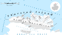
Sherman Island is an ice-covered island of Antarctica about 51 kilometres (32 mi) long and 16 kilometres (10 mi) wide, lying south of Thurston Island in the middle of Peacock Sound. The feature rises above the Abbot Ice Shelf which occupies the sound.
 Sherman Island Location in Antarctica | |
| Geography | |
|---|---|
| Location | Antarctica |
| Coordinates | 72°40′S 99°45′W |
| Area | 1,121 km2 (433 sq mi) |
| Length | 51 km (31.7 mi) |
| Width | 19 km (11.8 mi) |
| Administration | |
| Administered under the Antarctic Treaty System | |
| Demographics | |
| Population | Uninhabited |


It was delineated from aerial photographs taken by US Navy Operation HIGHJUMP in December 1946, and named by the Advisory Committee on Antarctic Names for Admiral Forrest Sherman, USN, Chief of Naval Operations, when preparations were being made for U.S. Naval support during the forthcoming International Geophysical Year operations.
Maps
- Thurston Island – Jones Mountains. 1:500000 Antarctica Sketch Map. US Geological Survey, 1967.
- Antarctic Digital Database (ADD). Scale 1:250000 topographic map of Antarctica. Scientific Committee on Antarctic Research (SCAR), 1993–2016.
See also
- Composite Antarctic Gazetteer
- List of Antarctic and sub-Antarctic islands
- List of Antarctic islands south of 60° S
- SCAR
- Territorial claims in Antarctica
Further reading
- M.J. Hambrey, P.F. Barker, P.J. Barrett, V. Bowman, B. Davies, J.L. Smellie, M. Tranter, Editors, Antarctic Palaeoenvironments and Earth-Surface Processes
- Cochran, J. & Jacobs, S. & Tinto, K. & Bell, Robin. (2014) Bathymetric and oceanic controls on Abbot Ice Shelf thickness and stability, The Cryosphere. 8. 877–889. 10.5194/tc-8-877-2014
- J.A. GRIGGS, J.L. BAMBER, Antarctic ice-shelf thickness from satellite radar altimetry, Journal of Glaciology, Vol. 57, No. 203, 2011, P 485
External links
- Sherman Island on USGS website
- Sherman Island on SCAR website
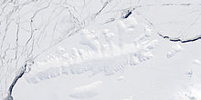
- Sherman Island area satellite image
- Updated weather for Sherman Island
- Long term weather forecast for Sherman Island
References
![]() This article incorporates public domain material from the United States Geological Survey document: "Sherman Island (Antarctica)". (content from the Geographic Names Information System)
This article incorporates public domain material from the United States Geological Survey document: "Sherman Island (Antarctica)". (content from the Geographic Names Information System)
На других языках
[de] Sherman-Insel
Die Sherman-Insel (englisch Sherman Island) ist eine eisbedeckte Insel mit einer Fläche von rund 1159 km².[1] Die Insel ist etwa 51 Kilometer lang und 16 Kilometer breit.[2] Sie liegt rund zwölf Kilometer südlich der deutlich größeren Thurston-Insel vor der Küste der westantarktischen Region Ellsworthland. Die Insel liegt im Peacock-Sund und ist vollständig vom Abbot-Schelfeis umgeben. Sie wurde erstmals nach Auswertung von Luftbildern der Operation Highjump aus dem Dezember 1946 kartiert und nach dem US-Admiral Forrest P. Sherman benannt.- [en] Sherman Island (Antarctica)
[es] Isla Sherman
La isla Sherman (72°40′S 099°45′O) es una isla cubierta por el hielo, en la Antártida, de aproximadamente 51 kilómetros (32 millas) de largo por 16 kilómetros (10 millas) de ancho. Situada en medio del estrecho de Peacock que lo separa de la isla Thurston. El rasgo sobrepasa la barrera de hielo Abbot que ocupa el estrecho. La isla Sherman no es reclamada por ningún país.[fr] Île Sherman
L’île Sherman est une île côtière inhabitée d'Antarctique occidental. Elle est située à 40 km au sud de l'île Thurston, au milieu du détroit du Peacock[1]. Prise dans la barrière d'Abbot et couverte de glace, elle est longue d'environ 51 km et large de 16 km. Elle a été identifiée en 1949-1950 grâce à des photographies aériennes prises au cours de l'opération Highjump, et baptisée en l'honneur de l'amiral Forrest Sherman, qui était, à l'époque, chef des opérations navales (Chief of Naval Operations).[it] Isola Sherman
L'isola Sherman è un'isola antartica.Другой контент может иметь иную лицензию. Перед использованием материалов сайта WikiSort.org внимательно изучите правила лицензирования конкретных элементов наполнения сайта.
WikiSort.org - проект по пересортировке и дополнению контента Википедии
