geo.wikisort.org - Island
Rathlin O'Birne (Gaeilge: Reachlainn Uí Bhirn[1]) is an island located to the south west of the district of Glencolumbkille, County Donegal, Ireland, and 2 km west of Malin Beg.
Native name: Reachlainn Uí Bhirn | |
|---|---|
 Rathlin O'Birne | |
| Geography | |
| Location | Atlantic Ocean |
| Coordinates | 54°39.816′N 8°49.951′W |
| Administration | |
Ireland | |
| Province | Ulster |
| County | Donegal |
| Demographics | |
| Population | (1) |
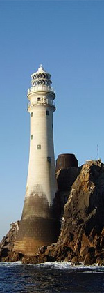
Lighthouse
Rathlin O'Birne lighthouse went into operation on 14 April 1856. In 1974, a Radioisotope thermoelectric generator was installed, making it home to Ireland's first nuclear powered lighthouse. [2] However, by 1987, the power output of the RTG had dwindled to an insufficient level and the lighthouse was converted to wind power, which was in use until 1991, at which point it was converted to solar power.[3]
A road, with a cut stone wall on both sides, runs from the beach to the lighthouse to protect the lighthouse keepers as they made their way across the island.[2]
Accidents
- On 7 January 1975, the trawler Evelyn Marie sank on the west side ("the rock") of Rathlin O Birne with the loss of 6 crew.
- A year later, in November 1976, the trawler Carrig Una sank in the same spot with the loss of 5 crew.[4]
- In July 2017, two men died when their RIB ran out of fuel close to the shore of Rathlin O'Birne, after having been rescued from the same area four weeks prior.[5]
References
- "Logainm Reachlainn Uí Bhirn". Archived from the original on 20 April 2017. Retrieved 19 April 2017.
- Walsh, David (2014). Oileáin. Pesda Press. p. 250. ISBN 978-1-906095-37-6.
- "Irish Lights - Rathlin Obirne". Archived from the original on 24 February 2021. Retrieved 18 April 2017.
- "RTE Radio 1 Documentary - Searching for answers". Archived from the original on 18 April 2017. Retrieved 18 April 2017.
- "Two fishermen drowned off Donegal coast 'had been rescued from same area before'". independent. Archived from the original on 10 July 2017. Retrieved 10 July 2017.
Places in County Donegal | ||
|---|---|---|
County town: Lifford | ||
| Towns |
|  |
| Villages |
| |
| Townlands | ||
| Islands | ||
| Other regions | ||
| ||
Lighthouses in Ireland | ||
|---|---|---|
Lighthouses are shown in anti-clockwise sequence beginning from the north and proceeding west, south, east, and back to north. | ||
| County Donegal |
|  |
| County Sligo |
| |
| County Mayo |
| |
| County Galway |
| |
| County Clare |
| |
| County Kerry |
| |
| County Cork |
| |
| County Waterford |
| |
| County Wexford |
| |
| County Wicklow |
| |
| County Dublin |
| |
| County Louth |
| |
| County Down |
| |
| County Antrim |
| |
| ||
На других языках
[de] Rathlin O’Birne Island
Rathlin O’Birne Island (irisch: Reachlainn Uí Bhirn[1]) ist eine zwei Kilometer vor der Küste Donegals gelegene Insel im Nordwesten Irlands. Sie liegt westlich der kleinen Ortschaft Malin Beg und des Slieve-League-Bergmassivs. Auf der Westseite steht ein Leuchtturm, dessen Betrieb automatisiert ist.- [en] Rathlin O'Birne
[fr] Rathlin O'Birne
Rathlin O'Birne est une petite île située au large des falaises de Slieve League au nord de la baie de Donegal. C'est une île inhabitée du comté de Donegal où est érigé le phare de Rathlin O'Birne qui est contrôlé par les Commissioners of Irish Lights (CIL).Текст в блоке "Читать" взят с сайта "Википедия" и доступен по лицензии Creative Commons Attribution-ShareAlike; в отдельных случаях могут действовать дополнительные условия.
Другой контент может иметь иную лицензию. Перед использованием материалов сайта WikiSort.org внимательно изучите правила лицензирования конкретных элементов наполнения сайта.
Другой контент может иметь иную лицензию. Перед использованием материалов сайта WikiSort.org внимательно изучите правила лицензирования конкретных элементов наполнения сайта.
2019-2026
WikiSort.org - проект по пересортировке и дополнению контента Википедии
WikiSort.org - проект по пересортировке и дополнению контента Википедии