geo.wikisort.org - Island
Inishbofin (Inis Bó Finne in Irish, meaning Island of the White Cow) is an island off the coast of Machaire Uí Rabhartaigh (Magheraroarty), County Donegal, Ireland.
Native name: Inis Bó Finne | |
|---|---|
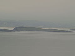
 Inishbofin as seen from Machaire Rabhartaigh, with Tory Island visible in the distance, October 2011 | |
 Inishbofin | |
| Geography | |
| Location | Atlantic Ocean |
| Coordinates | 55°10′23″N 8°10′08″W |
| Area | 1.2 km2 (0.46 sq mi) |
| Administration | |
Ireland | |
| Province | Ulster |
| County | Donegal |
| Demographics | |
| Population | 11 (2011) |
Geography
The island is a 120-hectare (300 acre) land mass, with an economy traditionally based on fishing and farming. Irish is spoken routinely. There are no pubs or shops on the island. There is a boat service to and from it but no regular ferry.[citation needed]
It is the largest of a small group of islands; the others, Inis Dúiche and Inis Beag, lie to the north and are uninhabited.[citation needed]
Demographics
Inishbofin's population dropped in 100 years from 166 (1911) to 11 (2011).
|
|
| |||||||||||||||||||||||||||||||||||||||||||||||||||||||||||||||||||||||||||||||||
| Source: Central Statistics Office. "CNA17: Population by Off Shore Island, Sex and Year". CSO.ie. Retrieved 12 October 2016. | |||||||||||||||||||||||||||||||||||||||||||||||||||||||||||||||||||||||||||||||||||
The table reports data taken from Discover the Islands of Ireland (Alex Ritsema, Collins Press, 1999) and the Census of Ireland. Census data in Ireland before 1841 were not complete and/or reliable.
Gallery
- Images of Inishbofin
 Inishbofin as seen from Tory Island
 The harbour
 Inishbofin
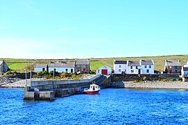 Landing at Inishbofin


See also
References
External links
- Inishbofin Island - The Island Website with information on the island and its history.[dead link]
- Inis Bó Finne - information from Comhdháil Oileáin na hÉireann[dead link]
- Inishbofin, Donegal - a first-hand account – with photographs – of one American's visit
- Historical Map of Inishbofin

This article related to the geography of County Donegal, Ireland is a stub. You can help Wikipedia by expanding it. |
На других языках
- [en] Inishbofin, County Donegal
[fr] Inishbofin (Donegal)
Inishbofin est une île irlandaise du comté de Donegal. On peut s'y rendre en bateau, bien qu'aucun service régulier n'existe. L'île a une église, un hôtel mais pas de police. On y parle principalement le gaélique et non l'anglais.[it] Inishbofin (Donegal)
Inishbofin (Inis Bó Finne in gaelico irlandese, che significa "isola della Mucca Bianca") è un'isola situata 2,5 chilometri al largo della costa di Machaire Rabhartaigh, contea di Donegal, Irlanda.[ru] Инишбофин (Донегол)
Инишбофин (ирл. Inis Bó Finne[1], англ. Inishbofin — «остров белой коровы») — маленький ирландоязычный рыбацкий остров на севере Ирландии вблизи побережья деревни Махаря-Раурти в графстве Донегол. Население — 11 чел. (2011).[2]Другой контент может иметь иную лицензию. Перед использованием материалов сайта WikiSort.org внимательно изучите правила лицензирования конкретных элементов наполнения сайта.
WikiSort.org - проект по пересортировке и дополнению контента Википедии